Golden Trout Wilderness, Sequoia National Forest, southern Sierra, Kern County, California
12 mile overnight ramble into the sierra alongside the Kern River and back
| North Fork of the Kern River From
Forks of the Kern trailhead to Kern Flat Golden Trout Wilderness, Sequoia National Forest, southern Sierra, Kern County, California 12 mile overnight ramble into the sierra alongside the Kern River and back |
| A river trail follows
the banks of the N. Fork of the Kern River for dozens, maybe hundreds,
of miles deep into the north sierra. Forks of the Kern trailhead gets you on this trail, which winds along her banks as the Kern carves canyons and meadows on her way to being dammed at Lake Isabella. Designated
by Congress to be a Wild and Scenic River, which forbids development
along her banks, the N. Fork of the Kern delivers primal, untrammeled scenery. This relatively easy hike is perfect if you enjoy discovering the unique rock formations and terrain carved by mountain rivers. After a 1000 ft. descent from the trailhead, the river path stays mostly level to Kern Flat. Exploring the untamed Kern, lined with giant sequoia and lodgepole pine forests deep in the mountain wilderness, gave me a sense of timelessness and connectivity to the earth. Part of any hiking adventure is getting there and this trip was one of discovery and exploration of the southern Sierra, the Kern River and Lake Isabella. The Kern is one of the largest and longest rivers in the Sierra. It flows north to south and has two main branches - the North Fork and the South Fork, separated by dozens of miles. The N. Fork is on the west side of the Sequoia National Forest and the S. Fork is on the east. I don't know why they didn't just give them separate names as they are two different rivers. A quick look at the map and you'd think they'd be called the W. Fork and the E. Fork. The Kern is popular with fly fisherman because it's full of colorful golden trout. |
To get a head start,
I packed the night before and set out from L.A. after a long Friday
work-day, slowly escaping the rush hour exodus north on I-5, then over
the pass and down on to the vast agricultural plains below Bakersfield.
Destination: Forks of the Kern trailhead in Sequoia National Forest,
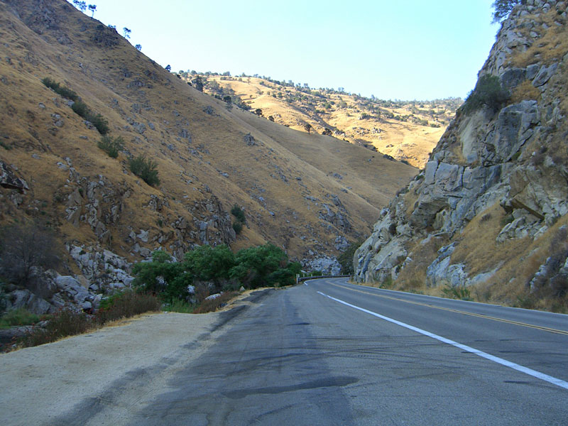
200 miles from L.A. East of Bakersfield, Highway 178 enters the the wall of eastern mountains and snakes along and above the noisy, boulder-strewn Kern River, flanked by steep mountains covered in a golden grass carpet. This is an amazing canyon carved by the Kern through giant mountains - you'll want to see it in the daylight if possible. It was after dark when I drove through the first night, so the first pictures below I actually took on the return trip in the late afternoon. |
| The Forks of the Kern trail is in good condition but could use a sign or two. The trailhead is at the far end of the parking lot from the entrance. You can hear the river
from above. The trail quickly drops 1000 ft. on steep switchbacks to the river, and after 1 mile, passes into the Golden Trout Wilderness, marked with a sign. Shortly after you enter the GTW, you'll see the river to the east/northeast. It's a good spot to get your bearings as this is the direction you'll be going. After you descend the mountain and just a few dozen yards before you reach a river basin, the trail splits. I got mixed up here thinking this stream
was the Kern when actually it's the Little Kern. Look for the path that
goes leftish, east/northeast into the woods along the stream, (not right, straight, or hard left
to a campsite). I put up some cairn markers here on the way back that may still be in
place to guide you. After a few hundred yards, the trail crosses the stream on a makeshift boulder bridge. The Little Kern is shallow, so it's not hard, but in the spring, you may have to get your feet wet. |
On the opposite side
of the stream is a large rocky overflow basin where there isn't much
of a trail. Look for cairn markers and head northeast.
Once along the river, the trail is relatively level, except for a deep canyon about 6-7 miles out where it climbs up and over a mountain. There are several excellent camping sites along the trail and others you'll find if you walk directly along the water. You'll know you're near Kern Flats when you come to a barbed wire gate across the path that you'll want to close behind you. You may find a herd of cows grazing here like I did. |
| STATISTICS |
| N. Fork of the Kern River from
Forks of the Kern trailhead to Kern Flats Elevation gain:–1300 ft. inbound Distance: Approx. 12 mi. one way Duration: 6 hours one way Difficulty: Moderate Water availability: Kern River flows year round. |
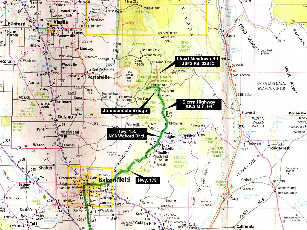
| From Los Angeles, take
I-5 north to Hwy. 99 to Bakersfield, about 3 hours. Go east on Hwy.
178 to Lake Isabella. then Hwy. 155 north, aka Wofford Blvd. or Garces
Hwy., to Wofford Heights. Continue through Wofford Heights on Wofford
Blvd., aka Burlando Rd., to Kernville. There is plentiful primitive camping on the western shore of Lake Isabella at campgrounds like French Gulch, a peninsula full of dunes just outside of the town of Lk. Isabella with great views of the lake and mountains. Last trip out, I arrived there late, rolled through the campground to the maze of dirt roads beyond and found a quiet spot right on the lake. There was no one collecting a camping fee, as I arrived late and left early. In Kernville, Wofford Blvd./Burlando Rd. veers right and becomes Kernville Rd. (Lk. Isabella to Kernville is not as confusing as it sounds from all the road name changes - just follow the main road and keep the lake on your right.) The Ranger Station is on a side street on the left shortly after you enter town - look for the sign. When Kernville Rd. ends, T/L on to Sierra Way, also known as Mountain Hwy. 99. There's a large grocery store on the right for supplies. There's no more gas after Kernville. |
Approx. 20 winding miles
north of Kernville on Mountain 99 is the Johnsondale
bridge, a popular rest stop/overlook just beyond Sherman Pass Rd.
From the bridge, continue 4.7 miles up the mountain and T/R Lloyd Meadows
Rd. Go 20 mi. and T/R on Forks of the Kern trailhead road. After 2.5
mi., this dirt road ends at large parking lot. Trailhead is at far end
from the road entrance. Leave nothing that looks valuable visable in
your vehicle.
The U.S. Forest Service requires you to acquire and carry a free Wilderness Permit for overnight visits to the Golden Trout Wilderness. (In some areas, visitor and trailhead quotas are in effect "to protect the wilderness from visitor impact and over use.") Permits are not required for day use. Permits are only valid for specific dates and areas. If you choose to have a campfire, a free campfire permit, verifying your knowledge of and adherence to fire guidelines, must also be carried. Campfire permits expire at the end of the calendar year. |
||
|
|||
| Getting there | |||||
 Highway 178 takes you out of the flat Bakersfield plain into the southern Sierra |
 Welcome to the Kern River |
 |
 |
 Around every turn is another amazing mountain formation. |
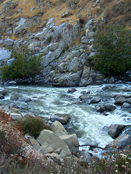
 The Kern is flowing strong even after a hot draught-ridden Summer. It's easy to imagine the power it has in Spring. |
 Water-carved rock high above the current water level. |
 The surrounding mountains are covered with sloping fields full of giant boulders |
|
 The lake, surrounded by tall mountains, is formed by damming the Kern. The small town of Lake Isabella is on the SW shore. |
||
 Panorama of the norhern end of Lake Isabella with the town of Wofford Heights. You can see the water level was much higher at one time. |
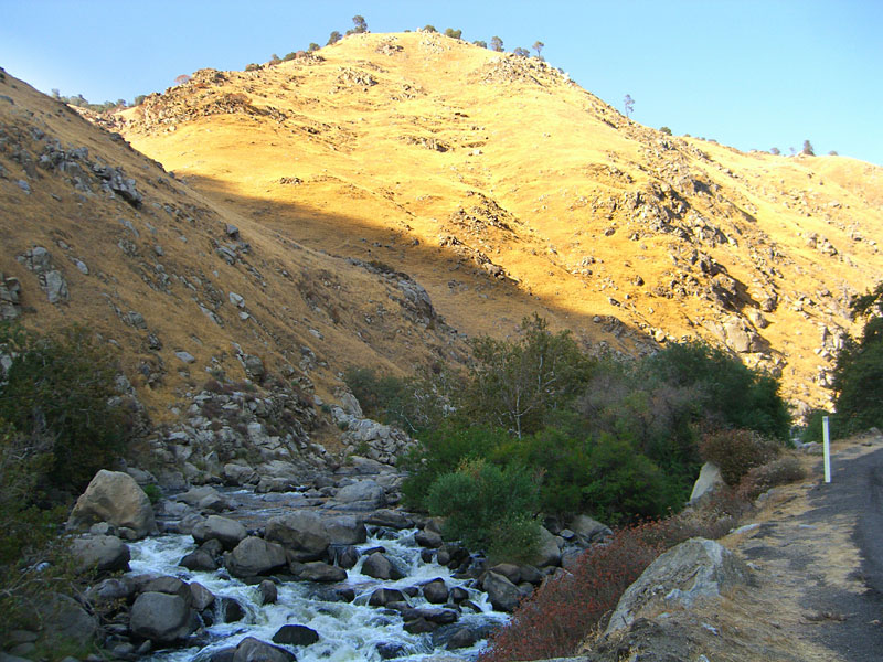
 Early the next morning and a 50 mile drive up the beautiful Kern Valley. |
 |
 At times lazy and relaxed, the river has many moods and is popular with rafters. |
||
 As a designated Nat. Wild & Scenic River, no development is allowed along its banks. I'm told the Kern has sections rated at Class 4 and even 5, only for advanced whitewater experts. |
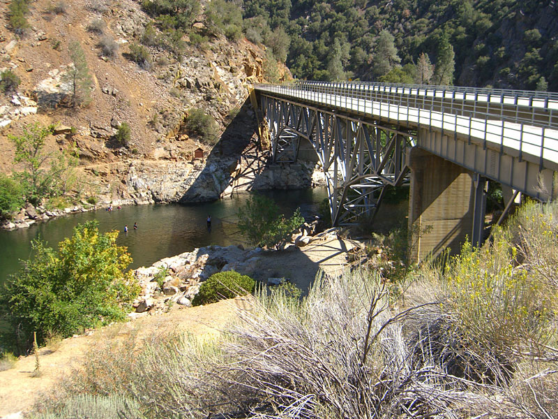 Johnsondale bridge over the Kern is a local landmark. On the opposite bank, you can see a popular trail that runs up the river several miles. In June 2004, woman on this trail was attacked by a mountain lion. She survived. It was later shot. |
 Up the mountain 4.7 miles from the bridge is Lloyds Meadow road, a 23 mile dead end road you'll follow that leads to numerous trailheads, including Forks of the Kern. |
 |
 "The Needles" is the name given to this mountain with jutting spires. Pictures just
can't capture the scale and height.
"The Needles" is the name given to this mountain with jutting spires. Pictures just
can't capture the scale and height. |
 20 miles up Lloyds Meadow road is the dirt road to the trailhead. |
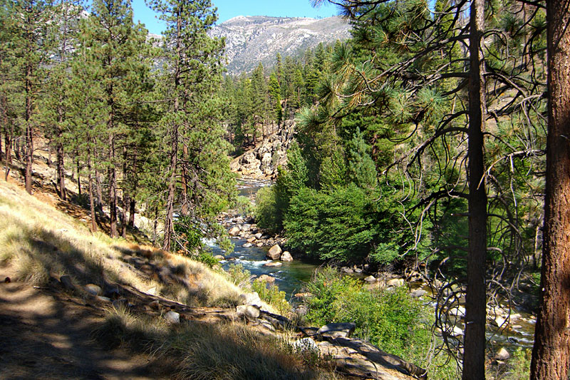
| The Trail | 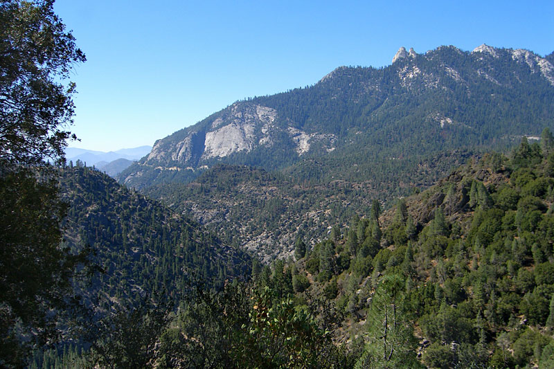 The hike starts out high with nice vistas south and west to the back of The Needles. That cut through the woods at the left base of the mountain is Lloyds Meadow road. You can hear the Kern rushing through the valley far below. |
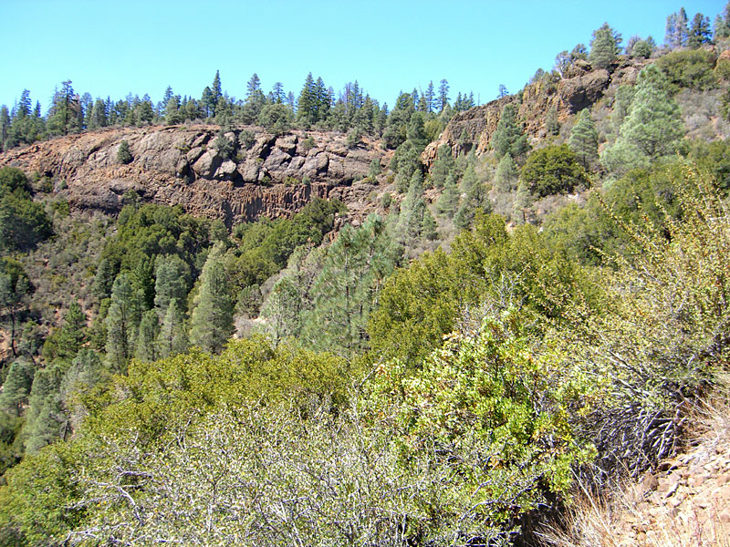 Postpile-type rock formations (Distant center). |
 After 1 mile, the trail enters the Golden Trout Wilderness, part of Sequoia National Forest. |
 |
|
 A nice vista northeast to where you'll be going. I recommend you orient yourself at this point as the trail separates at the bottom of this mtn. |
|
 A handful of anglers were hooking trout after trout, all catch and release. |
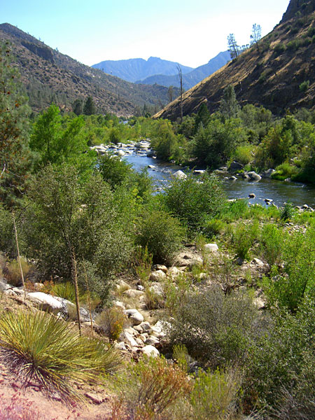
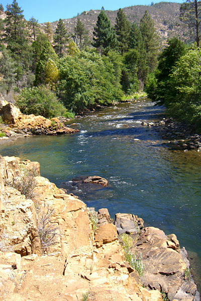
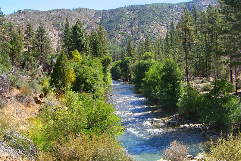
 An easy to follow trail runs along the bank and goes hundreds of miles north and east in to the High Sierra. Looking back to the west. |
 Deep swimming holes around every bend. |
 No sooner did I pause to watch this fellow, when he hooked a 12 incher. |
 After a swim break (it was cold!), and lunch, a perfect afternoon along the Kern. |
 |
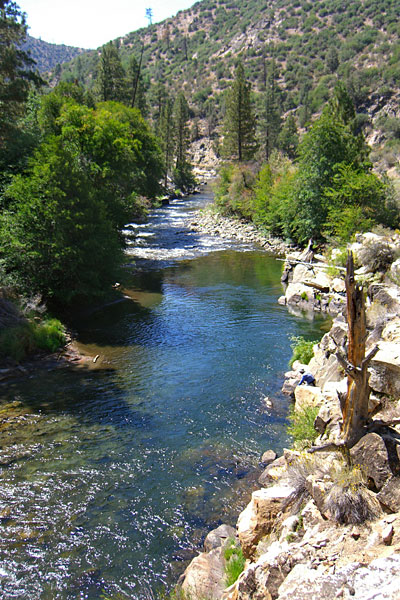
 Unusual rock formations loom high above the river. |
 I always scan rocks above the trail for animals as I pass. I keep a loud whistle and my knife handy and know the recommended techniques for the unlikely bear or mtn. lion confrontation. |
 At times the river lolled by lazily. |
 |
 After many miles and late afternoon, I came upon a barbed wire fence with a make-shift gate across the trail - Kern Flats. Another quarter of a mile through the gate, and there were dozens of cows! Surprised to see them way out here in the wilderness. But was about time for setting up camp, so I doubled back to a nice spot I'd passed a mile back. |
 Spied this inviting site (distant center) beside the river, with some primitive benches and table. Unfortunately, inconsiderate people had left some beer cans and trash, which I packed up and hauled out the next day. They did leave plenty of firewood though. |
 That night, the full moon came out like a beacon in the starry blackness, moon rays eerily revealing the far mountain from the summit down as it rose, until the giant disc appeared suddenly from behind the mountain, flooding the canyon with light, erasing the stars. |
 It got down to 40 degrees overnight, but as soon as the sun rose above the canyon walls, it got warm fast.After a relaxing breakfast, it was time to break camp and head out. There are many nice sites like this one along the river. |
 You could easily believe this unusual green rock was cut by machine. It was probably erosion that carved it, but it may have been dynamite, although there are no drill holes. |
 Ancient giant trees line the trail. |
 Another perfect day for the hike out. |
 Saw fewer than 12 people these two days - all but one was fishing. Everyone was as happy to be out here along this wild river as I was. |
 Pictures give only small, two-dimensional insight to the sights, scents and sounds of this rugged, untamed land. |
 Unless you experience it firsthand, it's difficult to convey the remoteness of this wilderness, the height of the surrounding mountains, the scale of the giant trees. |
 There is considerable effort and some risk to be here and wonder and amazement for the payoff. Another hiker near the white sulphur spring meadow, with The Needles above. |


