Golden Trout Wilderness, Southern Sierra, Kern County, California
Overnight hike to a string of mountain lakes
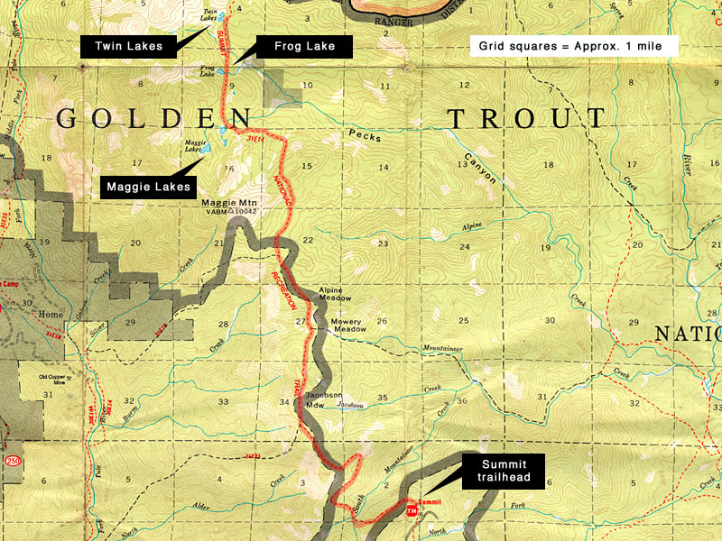
| Maggie Lakes, Frog Lake, Twin Lakes
via Summit trail Golden Trout Wilderness, Southern Sierra, Kern County, California Overnight hike to a string of mountain lakes |
| Maggie Lakes are three
jewels in the South Sierra's Golden Trout Wilderness, about a 9 mile hike
from Summit trailhead. Although they aren't named as such, I call them
lower, middle and upper Maggie Lake. Frog Lake and the Twin Lakes are
one and two miles north, respectively. Who is Maggie? I don't know, but
get ready for enormous trees, amazing rock formations, a string of
pristine wilderness lakes and a strenuous but rewarding workout
exploring a giant wilderness area that relatively few know about. This is an overnight hike of about 25 mi. total, out and back again. It took me a little more than 5 hours, including two 10 minute breaks, to get to the first Maggie Lake. From the trail map, one would expect grand views of 10,042' Maggie mountain much of the hike, as the trail winds up and around her flanks, but there are only a few hard-won glimpses of her elusive summit through the thick forest. The sign at the trailhead says 7 miles to Maggie Lakes, but that must be as the crow flies. I'm going to call it more like 8 1/2 to 9 miles with all the switchbacks. It's a strenous hike - there are some very steep segments that will have you breathing hard. After a long drive up from LA after work, I arrived at the Summit trailhead parking lot past 11:00 Friday night, set up my tent and went straight to sleep. Hunting season had begun and I shared the dirt and gravel parking area with several tents and trucks with hunters and a giant horse trailer too. |
Next morning, after a
quick breakfast, I tied a bright color on my pack and was on the trail
by 7:30, trying to put as much distance as possible between myself and
a group of 4 loud dayhikers who rolled up in a cloud of dust just as I
was breaking camp. Spoke with a young deer hunter one mile in who said he'd already seen 3 bears. He'd yelled out "Bear!" to me from the trail high above so that I could see one, but he was in camouflage and I couldn't see him until I got a lot closer, so I missed it. Because hunters are supposed to haul out their kills, they generally don't trek into the wilderness very far from their trucks. So the farther in you go, the less chance you have of meeting up with hunters, except those on horseback. I'm not inclined to kill a deer or bear for sport myself, but I think it may be the only way they'll learn a healthy fear of humans. With the klak klak from my trekking poles announcing me, I don't have too many animal encounters, but I did get studied by several deer with their fawns on this hike. I ran across only that one group of dayhikers and about 10 horsemen on the trail the whole two days. |
| Summit Trail is in good
shape and easy to follow for the most part but many of the trail intersection
signs are either down or damaged as of this writing, so bring a map
and a compass or GPS. The path is generally good condition hard pack
dirt. There is moderate use by stock (horse & mule), but not enough
to damage it. The trailhead is at the far end of the parking area. I found out from the Springville ranger station that there hadn't been a maintenance crew on this trail in at least two years, so I didn't know what to expect. But I'd read there had been lightning fire closures in this area since then so that meant fire crews may have been out clearing trees that had toppled across the path. There were two or three short detours around fallen trees on this visit, including one giant sequoia near Griswold Meadows that a new trail was created to bypass. (Stay left). From the trailhead, the path winds around and down the mountain right away, almost 1000 ft. to a gurgling cascade, then climbs right back up the adjacent mountain 1000 ft. and more. As you start down, that mountain there on your right directly across the valley is where you'll be going back up, up, up to the same height. Then it levels off for a mile before another very steep segment of switchbacks that put you high on a ridge, with expansive views east and west. From here, the trail is more level for a few miles through thick forest to a series of alpine meadows. When you near Maggie mountain, once again the trail climbs steeply, circling the perimeter. (You don't see the summit from the trail). After rounding a high point at the north flank of Maggie mountain, you'll first see the valley ahead and the mountains to the northwest that hold Maggie Lakes. |
Middle Maggie is just above lower. A boulder slope separates two. There is a semblance of a trail around the far (west) side of the lake. There's really no trail to speak of to the upper lake, just head southwest up the hill from Lower Maggie and you'll see it in ten minutes. North of Maggie Lakes, Summit trail to Frog Lake and Twin Lakes climbs 500 ft. up through a giant boulder field and is easy to lose. This is where I was thankful to see horse manure to follow. You'll need to be extra vigilant, keep your map and compass handy and look for cairn markers to stay on the trail here. After Frog Lake, the trail is easier to follow to Twin Lakes. |
| STATISTICS |
| Maggie Lakes, Frog Lake, Twin Lakes
via Summit trail Height: 9500-10,000 ft. Elevation gain: Approx. 2000 - 2200 ft. one way Distance: 12-13 miles one way Duration: 8-9 hours one way Difficulty: Strenuous Water availability: Several streams flowing. Lakes are full year round. |
| From Los Angeles, take
I-5 to Hwy. 99 to Bakersfield, about 3 hours. The fastest route is to
stay north on 99, a divided highway, then go east on Hwy. 190 to Porterville
and Springville. You could also take Hwy. 65 north out of Bakersfield,
a more direct but slower route to Porterville. From the highway
190 bridge over the Tule River on the east side of Springville, it's
24.4 miles on Hwy 190 east up the mountain to North Road (Forest Service
road 21S50). T/L (north) on to North Road. There was no sign post for
North Rd. on my trip, but there is an "End Hwy. 190" sign. (Highway
190 then becomes "Mountain 99"/Sierra Highway down to Kernville.) From
here, it's 10.5 miles to Summit trailhead. North Road is long and twisty with numerous turnoffs and sub-roads, and provides access to many camps and trailheads - among them Lewis Camp, Clicks Creek, Jordan Peak and Summit trailheads. The first few miles are pavement, then a combination of dirt and pavement. The last few miles are dirt and rock and the road narrows to little more than one lane, so keep an eye out for wide spots in case you have to back up some distance to let someone by. After a few miles in, you may encounter herds of black cows in the road at any time. Much of the length is sided with tall trees so there is little orienting yourself without a map and signs or a GPS. |
The entire length of
North Road to Summit trailhead is accessible via passenger car in dry
weather, but the last few miles are covered with large jagged stones,
which make for slow going. The U.S. Forest Service requires you to acquire and carry a free Wilderness Permit for overnight visits to the Golden Trout Wilderness. (In some areas, visitor and trailhead quotas are in effect "to protect the wilderness from visitor impact and over use.") Permits are valid for specified dates only and not required for day use. If you want a campfire, a free campfire permit, verifying your knowledge of and adherence to fire guidelines, must also be carried. Campfire permits don't expire and can be reused.
| ||
|
|||
| Getting there | |||||
 From Hwy 190, the southern Sierra rise up from the plains behind Springville. |
 Lake Success, a reservoir east of Springville, fed by the Tule River. |
||||
 From Springville, Hwy. 190 climbs 25 miles and 3000 ft into the Sierra. |
 East of Springville, the Tule has cut a deep and impressive gorge. |
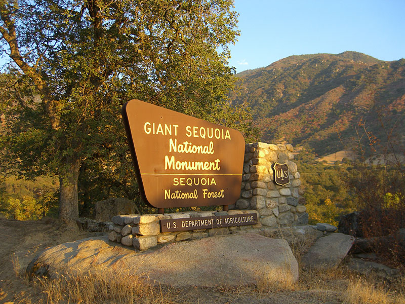 President Clinton signed legislation that designated the Giant Sequoia National Monument to be a distinct part of Sequoia National Forest |
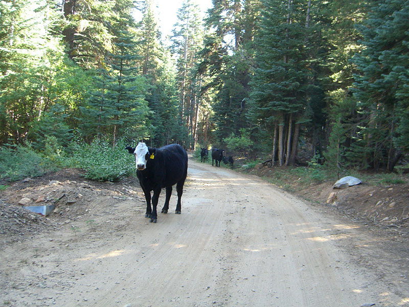 Beware of free-range cattle on North Rd., which skirts numerous fence-free meadows and pastures. A series of cattle guard pits keep them from wandering off. |
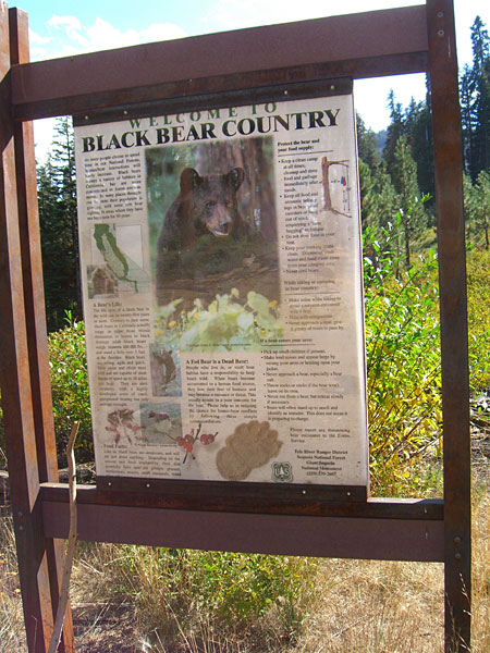 Bear sign at Summit trailhead. Here is big version, in case you want to read it. |
|
| The Trail | ||||||
 Looking back as the trail descends rapidly through tall pines. |
 Into the land of the giants as the sun comes up. |
 After a 1000' climb over 2 miles to 8500', you gain a ridge with expansive views on both sides. |
 Looking west. |
|||
 Vista east |
 The soaring height and massive scale of the trees indescribable. |
 A bright green, fern-like plant has infested many parts of the forest. |
 Aptly named Alpine Meadow, one of a series of alpine meadows. |
 Griswold Meadows, unmarked on the FS map, is one of the nicest on the trail. |
||
 Wise to make noise as you walk in to this forest, so as not to startle an ill-tempered bear. |
 The crest of this high ridge, a spur of Maggie mtn., is the highest point of the hike. You've hiked about 2000' up, and about 1000' down over the last 7-8 miles to get here. |
 Around the ridge is the first glimpse of the high valley that holds Maggie Lakes, 1-1.5 miles away. From here it's a long way down and then up again to reach the first lake, which is behind that mountain on the far left. |
 First sight of Lower Maggie after it seems you must have completely circled it. The FS map isn't very accurate. The peak is called N. Maggie, one of Maggie mountains 2-3 summits. |
 At the NW end of the lake, Summit trail has been decorated with rocks. |
||
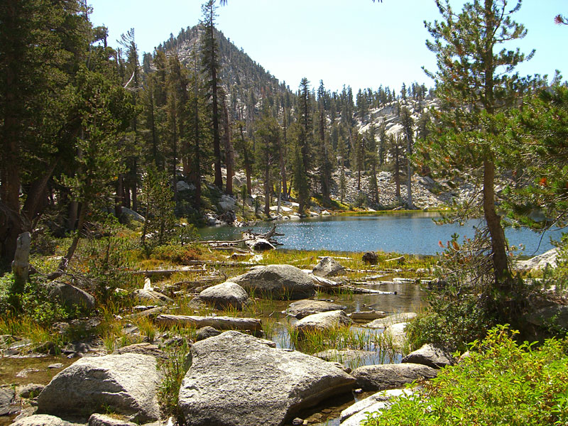
 Lower Maggie Lake from above |
 Lower Maggie Lake |
 A giant boulder slope separates the lower and middle lakes |
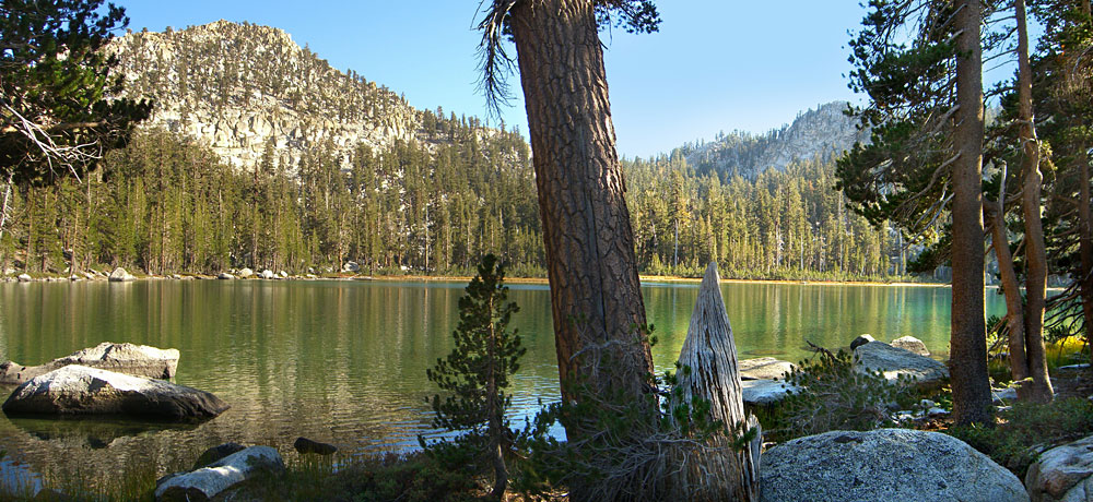
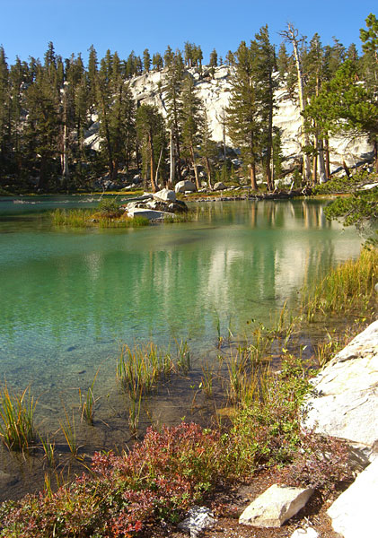
 middle Maggie Lake is a perfect example of a pristine wilderness lake |
|||

Middle Maggie Lake with N. Maggie mountain above it. |
 Middle Maggie Lake |
 After a 15 minute trail-free scramble Southwest, up the mountain from middle Maggie using a compass, the upper lake appears through the trees |
 |
|||

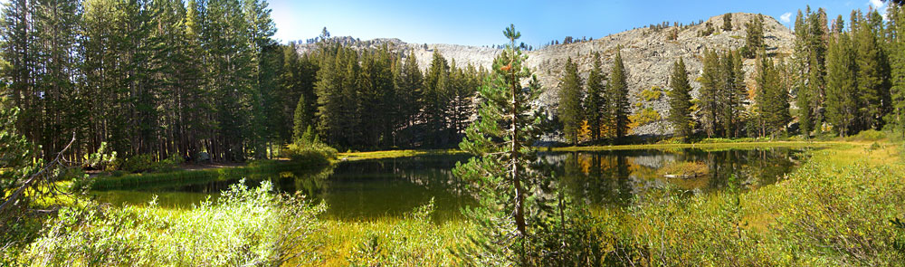
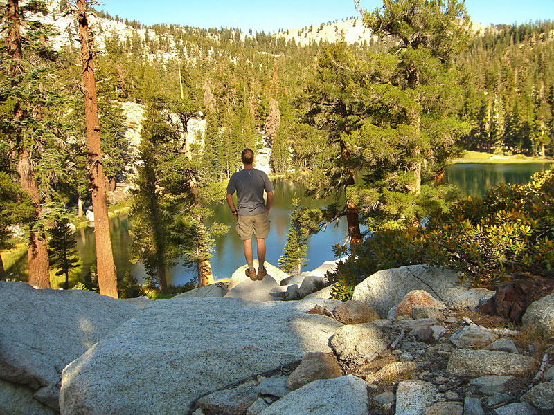
Upper Maggie Lake is the biggest of the three, surrounded by giant boulders and huge trees. N. Maggie mountain behind it. |
 Crystal clear water |
 |
 The water this time of year is way cold for a swim, but nice to cool off your feet in. |
|||
 After a relaxing lunch, I set out north to check out the other lakes. Looking back to N. Maggie Mtn. |
 Primal landscape above Maggie lake. Easy to lose the trail here. |
 North from Maggie Lake, its up, up, up another 400 feet in elevation to Frog Lake. Many glacial erratics along the trail. |
 Giant boulders and rock formations populate this area. |
 I think this is a glacial erratic, rather than erosion. As the glaciers melted, they left large boulders in unusual places. |
 The trail climbs through an ancient forest, seen only by very few people on earth. Easy to imagine there are entire mountains here no human has ever set foot upon. |
|
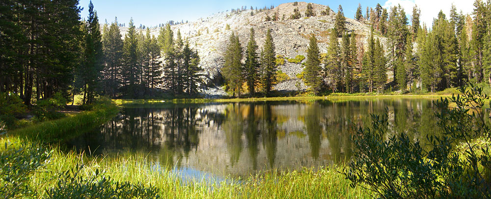
 Frog Lake, still going after years of sustained draught. |
 Toppled giants can lay around hundreds of years without disintegrating. |
 The western Twin Lake. Some horsemen had an extensive camp (left) set up on the isthmus between the lakes. They were surprised to see someone on foot way up here. |
||||
 Western Twin Lake |
 The eastern Twin Lake. After exploring some, I decided upper Maggie was the nicest of the bunch and backtracked 2 miles to camp on her shores. |
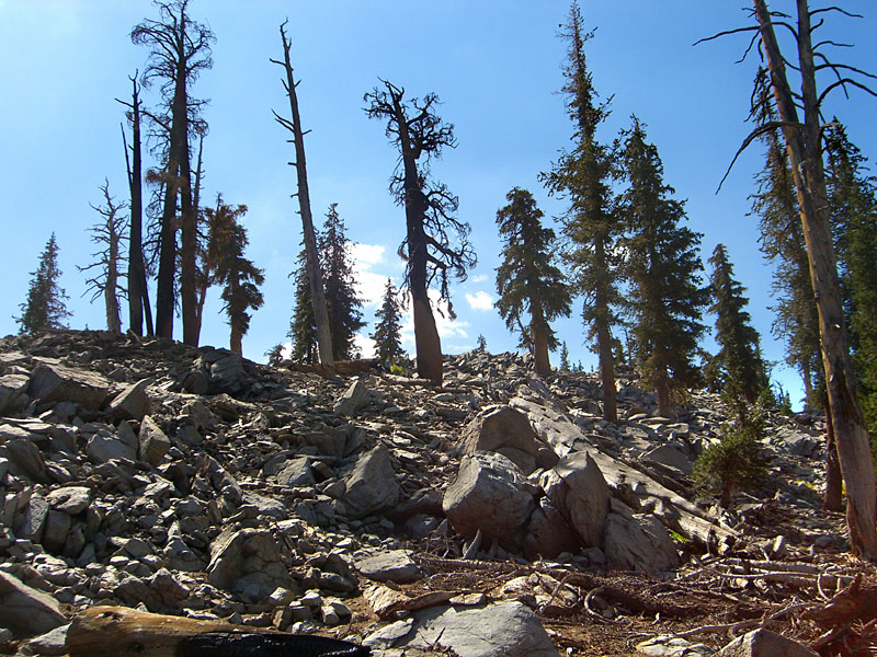
 Fires scorch these trees into bizarre husks, a testament to the strength of their bark and sap. |
 Found a great campsite and had a perfect evening of campfire dinner, hot chocolate, star-gazing and echo-shouting. No one around, except a large, late night camp prowler of undetermined species. |
|||
 After a cold, star-filled night, a warm lakeside morning breakfast on upper Maggie |
 Another awesome day for the hike out. Upper Maggie Lake. |
 Last look at lower Maggie |
 Without a human for scale, its difficult to show how enormous this sequoia - about 2 miles from the trailhead - is. |
 Generous amounts of dirt negate sticky pine sap. Clean freaks need not apply. |
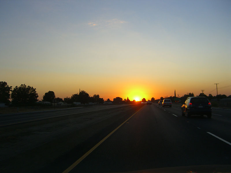 The most gigantic sunset ever on the drive out |
|


