Golden Trout Wilderness, Southern Sierra, Kern County, California
30 mile roundtrip overnight hike up the Kern River to a pair of remote mountain lakes nestled in alpine peaks
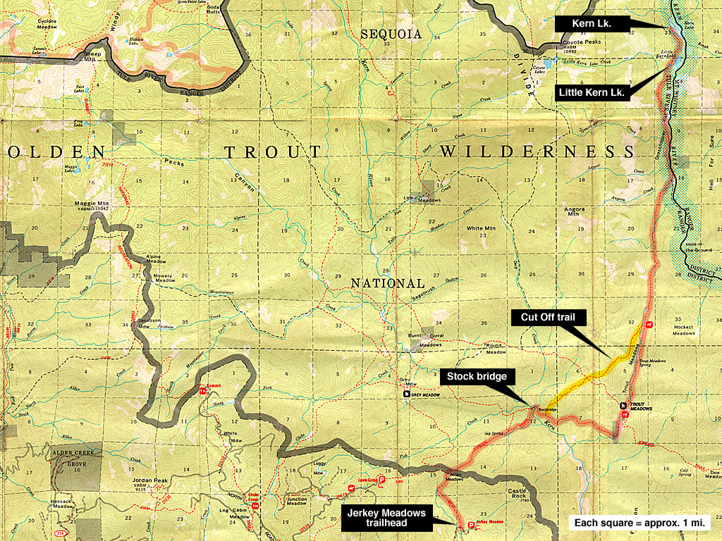
| Kern Lake, Little Kern Lake from
Jerkey Meadows trailhead Golden Trout Wilderness, Southern Sierra, Kern County, California 30 mile roundtrip overnight hike up the Kern River to a pair of remote mountain lakes nestled in alpine peaks |
| As part of my exploration of the Golden Trout
Wilderness and the Kern River, I picked out these two backcountry lakes
from the map because they lie beside the river and the 15 miles hike
out is do-able as an overnighter (with an early start). Also, I wanted
to scout out the area for an extended future trip north of here when
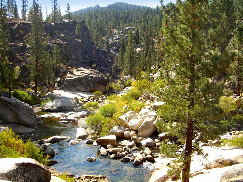
I can take more time off. The drive east into the southern Sierra from Bakersfield, then chasing the winding Kern River north to the trailhead is a visual feast. Daylight travel highly recommended. Ten miles up Lloyd Meadows Rd. is the amazing The Needles mountain, giant granite spires that claw at the sky. Among the highlights of this hike is a deep canyon carved by the Little Kern River, spanned by a steel horse bridge, and then Trout Meadows, a series of green pastures through an ancient forest of lodgepole pine and cedar that extend for several miles. Ten miles out, you meet up with the Kern River for the first time, rushing south from the High Sierra. The trail follows the wide Kern basin several miles, flanked by impressive, towering peaks, then climbs through rugged and rocky terrain to the first lake, Little Kern, surrounded by pastures and bordering the river. A short hike up a ridge north of Little Kern lake, then a rapid descent accesses Kern Lake, with its grassy shores and backdrop of giant peaks. The alpine vista from Kern Lake is inspiring and a short, overnight trip offers only a tantalizing glimpse at the area. Next trip, I'll be sure to allow an extra day to explore the lakes area. The trail continues north along the Kern River deep into the northern Golden Trout Wilderness, and on in to Kings Canyon and Yosemite Parks. There are no roads through the Golden Trout and only permitted hikers and equestrians are allowed on the trails. This part of the southern Sierra has a history of cattle ranching and remains equestrian/livestock friendly long after it was acquired by the Forest Service. Hikers should plan on sharing the southern, sub-alpine Golden Trout Wilderness with horse and mule trains. There are numerous barbed wire fences to keep stock contained and hikers have to open and close many crude gate-like contraptions across the path. |
I'm told cattle are
allowed to graze in selected areas of the GTW at different times of
the year. The ranger station can tell you when and where if you're concerned
about coming face to face with an entire herd on the trail. I didn't
see any cattle this trip. It seems strange to me to drive cattle deep
in to a wilderness full of bears and mountain lions and rattlers, but
I guess green pastures aren't easy to come by. Large segments of the
trail have been trodden into deep sand, which is more fatiguing to walk
in than a hard trail. The up side is that hoove prints (and droppings)
help you to locate the trail when it's unclear. All the riders I shared
the path with were very friendly and helpful. Some have been riding
and camping in this wilderness for generations. I saw about 10 riders and 3 other hikers on the trail my two days out. I left LA Friday after work at 5:30, crawled through rush hour traffic on I-5 north and was camping at the Jerkey Meadows trailhead by 11:00pm, ready to get an early start. The temperature dropped to 20 degrees, just as the forecast I was monitoring (very important!) said it would be. I set out at 7am and by the time I took a lunch break, the temperature had risen to a balmy 45 degrees. After almost 9 hours, I arrived at Kern Lake as daylight faded. The temperature dropped rapidly as I set up camp, but a warm meal and hot chocolate beside a dancing fire erased any discomfort. I ended the evening watching the 3/4 moon rise above giant black peaks reflected in the lake as shooting stars blazed across the sky. In the morning, it was 20 degrees again as I packed. Hit the trail at 7 and was back at the car by 4:30, and back in LA in 3 1/2 hours. A week later, the first major storm of the year blew in and the southern Sierra was covered in snow. |
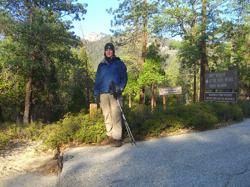
| The trails from Jerkey Meadows
trailhead to Kern Lakes are in good condition and relatively easy to
follow, but a good map and a compass or GPS are essential due to several
confusing intersections and paths not marked on the map and some signs
that are down or missing. Because of its popularity with horse parties,
the path is usually wide and clear, but unfortunately, trodden into
deep sand in many places, requiring much more effort to carry a heavy
pack than a hard dirt path. The Jerkey Meadows trailhead, at the very end of 23 mile long Lloyds Meadow road, starts deep in the wilderness in a thick forest of giant conifers. As you enter the parking lot, the trailhead is just to the left. To the right is parking for horse trailers; to the left, cars. The trail climbs 1000 feet right away to join the Jordan Trail on the ridge. On the way, you'll see an unmaintained shortcut north up the ridge that may confuse you on the return trip. I came down this way accidentally but wouldn't recommend taking it up as its extremely steep, slippery and washed out. (On the return trip, when you've re-gained this high ridge above the bridge and eventually come to an unmarked trail down on your left, you may think this is the trail to Jerkey Mdws. you came up. It's not. Note the sign on the right that says "Main trail" and continue straight to avoid this shortcut.) Once you're atop the ridge, the path splits twice with no signs and neither path looks bigger. The first split is clearly marked on the USFS map (at right) as a shortcut north to the Grey Mdws. trail. The second split isn't shown on the map. I went left at the 2nd split and this also came out on the Grey Mdws trail near an interesting boulder formation (4th pic below), then down to the bridge. The main path at the 2nd split is on the right, as I found on the return trip. From the ridge, the trail descends 1000+ feet to a deep and rugged gorge carved by the Little Kern River, where it crosses a large steel livestock bridge. A few hundred yards beyond the horse bridge is the "Cut Off" trail over a mountain (see map), an extremely steep shortcut that will take 1- 1.5 mi. off the distance, but be prepared for a serious workout. A broken sign on the ground was the only marker. The Cut Off trail has some challenging terrain, washouts and loose, slippery dirt and shale on steep slopes so it's not suitable for horses. Finding Cut Off trailhead on the southbound return trip is difficult as there were no signs and virtually no path visable from the main trail. It's just beyond a large horse campsite on the west side of the trail and luckily, some horsemen were able to point me to it. |
A few miles from the bridge, up and around a mountain east and north,
is the first of the Trout Meadows. The meadows extend 5-6 miles due
north and although there is little elevation gain, slogging through
the sandy trail is tiring.
Finding a campsite along Kern Lake is a challenge. The trail descends a very steep slope on the west side of the lake, so you must walk more than halfway up the lake before you can get close to the water, which is bordered by tall grass and reeds. When the trail descends to a few dozen feet above the water, there's a relatively flat spot where I was able to pitch a tent and have a safe fire, although it was closer to the water than I wanted. It was getting cold when I arrived, and the light (and my energy) was fading, so I didn't hike the 20 minutes around the lake to more suitable spots along the river. |
| STATISTICS |
| Kern Lakes Oct. 10-11 , 2008 Height: Approx. 9000' Elevation gain:2000-2500' Distance: 15-16 miles one way Duration: 8-9 hours one way Difficulty: Moderate Water availability: Little Kern and Kern River flow year round. Several streams flowing. The lakes remain full year round. |
| From Los Angeles, take
I-5 north to Hwy. 99 to Bakersfield, about 3 hours. Go east on Hwy.
178 to Lake Isabella. then Hwy. 155 north, aka Wofford Blvd. or Garces
Hwy., to Wofford Heights. Continue through Wofford Heights on Wofford
Blvd., aka Burlando Rd., to Kernville. There is plentiful primitive camping on the western shore of Lake Isabella at campgrounds like French Gulch, a peninsula full of dunes just outside of the town of Lk. Isabella with great views of the lake and mountains. Last trip out, I arrived there late, rolled through the campground to the maze of dirt roads beyond and found a quiet spot right on the lake. There was no one collecting a camping fee, as I arrived late and left early. In Kernville, Wofford Blvd./Burlando Rd. veers right and becomes Kernville Rd. (Lk. Isabella to Kernville is not as confusing as it sounds from all the road name changes - just follow the main road and keep the lake on your right.) The Ranger Station is on a side street on the left shortly after you enter town - look for the sign. When Kernville Rd. ends, T/L on to Sierra Way, also known as Mountain Hwy. 99. There's a large grocery store on the right for supplies. There's no more gas after Kernville. |
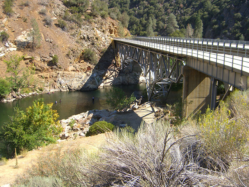
Approx. 20 winding miles
north of Kernville on Mountain 99 is the Johnsondale
bridge, a popular rest stop/overlook just beyond Sherman Pass Rd.
From the bridge, continue 4.7 miles up the mountain and T/R Lloyd Meadows
Rd. Go 23 mi. to the end of the road and the Jerkey Meadows trailhead
parking lot. Leave nothing that looks valuable visable in your vehicle.
The U.S. Forest Service requires that you carry a free Wilderness Permit for overnight visits to the Golden Trout Wilderness. (In some areas, visitor and trailhead quotas are in effect "to protect the wilderness from visitor impact and over use.") Permits are not required for day use. If you choose to have a campfire, a free campfire permit, verifying your knowledge of and adherence to fire guidelines, must also be carried. |
||
|
|||
 Drove up from LA after work, arrived at 11pm and camped
out at the trailhead. Hit the trail at 7am, temperature a brisk
20 degrees. Drove up from LA after work, arrived at 11pm and camped
out at the trailhead. Hit the trail at 7am, temperature a brisk
20 degrees. |
 The Jerkey Meadows trail gets busy going up right away. After a 1000 ft. climb, it intersects with the Jordan trail and offers glimpses of surrounding peaks to the northern destination. |
 If we could all look as good when dead as this cedar does... I could stand in burn hole at left. |
 Unique boulder formation above the Little Kern river canyon not far from the horse bridge. |
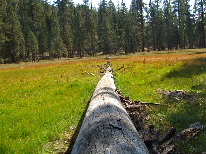
 Five miles of trail and you reach a deep canyon carved by the Little Kern river |
 Little Kern river is noisy and full of energy even after a long dry summer. |
 Weathered boulders above the Little Kern near the horse bridge. |
 Horse bridge, built in 1957 - must have been replaced recently. |
 After I crossed, I watched from the ridge above as a mule train approached. Instead of crossing the bridge, they
forded the stream under it. After I crossed, I watched from the ridge above as a mule train approached. Instead of crossing the bridge, they
forded the stream under it. |
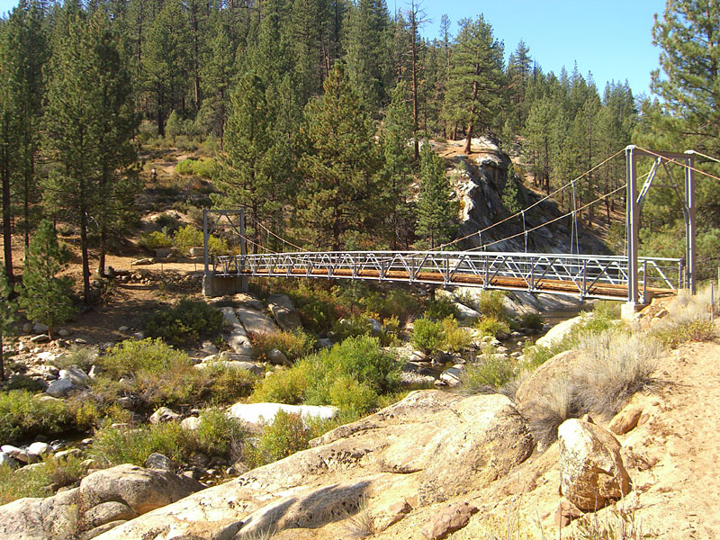 Guess they don't like heights. Must use it only when the water is high. |
 The ancient rock formations, the colors and sounds in this canyon invite exploration. |
 |
 First glimpse of Trout Meadows. Strange to see barbed wire fencing in a number of horses way up here where there are no roads. |
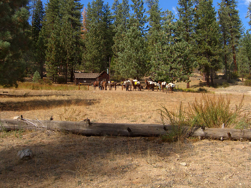 A horse camp with unoccupied ranger hut. This group of horses and 6 fully-packed mules was destined for a week of fishing on Little Kern Lk. (I made a note to continue on past that lake!) |
 Much of the Trout Meadows portion of the trail wanders through forests of giant pine and cedar. Through the meadow, the trail has been trodden in to 4-5 inches of deep sand. |
 |
 A couple on horseback with their dog passed by me to catch up to their party in the mule train. They are the black specks at the far end of the meadow. |
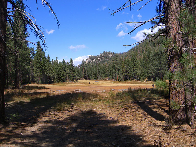
 Trout Meadows is in a high valley, surrounded by dramatic ridges. |
 A few miles north of the last meadow, the plain T's into a ledge. My camera doesn't capture it, but the visability was crisp and clear for miles. |
 From here, you see and hear the Kern River for the first time and the valley to the north where the lakes lie. |
 A long descent and finally you are beside the rushing Kern River. |
 Rugged peaks tower above the trail |
 |
 One of many makeshift gates across the path that you must open and close behind you to keep livestock from wandering off. |
 Much of the trail north is along the Kerns sandy overflow basin, out of site of the river, which is behind a berm of giant boulders |
 Rivulets of run-off water meander among the giant trees, seeking out the river. It's a wondrous wilderness to discover, but the deep sand full of hoof prints makes for a tiring slog. |
 After 14-15 miles out, feeling pretty beat, you know the lakes are close now, probably right around that mountain there on the left. |
 In a few minutes, the trail veers away from the nice flat river, then turns and climbs 600 ft. of vertical switchbacks up and over this mountain, which I dub "heartbreak hill". Aargh! There must be a steep canyon or waterfall the trail circumnavigates. |
 Finally, the first glimpse of Little Kern Lake from the south after almost 10 hours out and over 2000 ft. of ascent, and about the same of descent. The horse group has set up camp in the trees between the lake and the Kern River on the right. |
 Little Kern lake from the ridge on the north end looking south. Numerous horses are running and playing on the meadow by the lake. Surrounded by tall peaks, this lake would be most inviting mid day. |
 Another steep trek high up a boulder strewn ridge and then, finally, the first glimpse of Kern Lake far below. Too bad my camera is unable to capture the true colors in this kind of light |
 Kern Lake is surrounded by giant peaks and seems very remote as daylight slips away. Much of the shoreline is marshy and grassy - not particularly inviting for a camp site, but appealing to abundant wild fowl. On the far side, through the trees, you can hear–but can't see–the energetic Kern river rushing south. |
 I set up camp at the first flat spot I came to and had a warm fire going in no time. The night was extremely cold and clear. A giant 3/4 moon joined me right away and kept me company the rest of the evening. After a hot dinner, I sipped hot chocolate and stargazed, lying back against a sloping rock by the fire. |
 In the morning, snow flurries were frozen to my tent. After a fire and a warm breakfast, I was ready to head back. |
|
|
 Coming back, I took the Cut Off trail - a very steep ascent and descent. In the middle, I stopped for a break at this ancient cedar guarding a trail intersection |
 After 8+ hours, this welcome view of the canyon that holds Lloyds Meadow road, and the backside of The Needles above it, signals the last mile back to the trailhead. |
||||

