Spend the night on top of the highest peak (11,501 ft.) in Southern California.
| San Gorgonio mountain via South
Fork trail Spend the night on top of the highest peak (11,501 ft.) in Southern California. |
| San Gorgonio mountain
is 110 miles south of LA in the San Bernardino Mountains, which separate
the desert from the ocean. The surrounding San Gorgonio Wilderness is
managed by the U. S. Forest Service and is home to a variety of wildlife
including black bears, rattlesnakes, deer, bighorn sheep and mountain
lions, among others. The summit is a popular destination, accessible
via trails from many directions, and hikers climb to its windswept heights
in every season for 360 degree views of So. California. It's do-able
as a round trip dayhike if you're in good shape, start early, travel
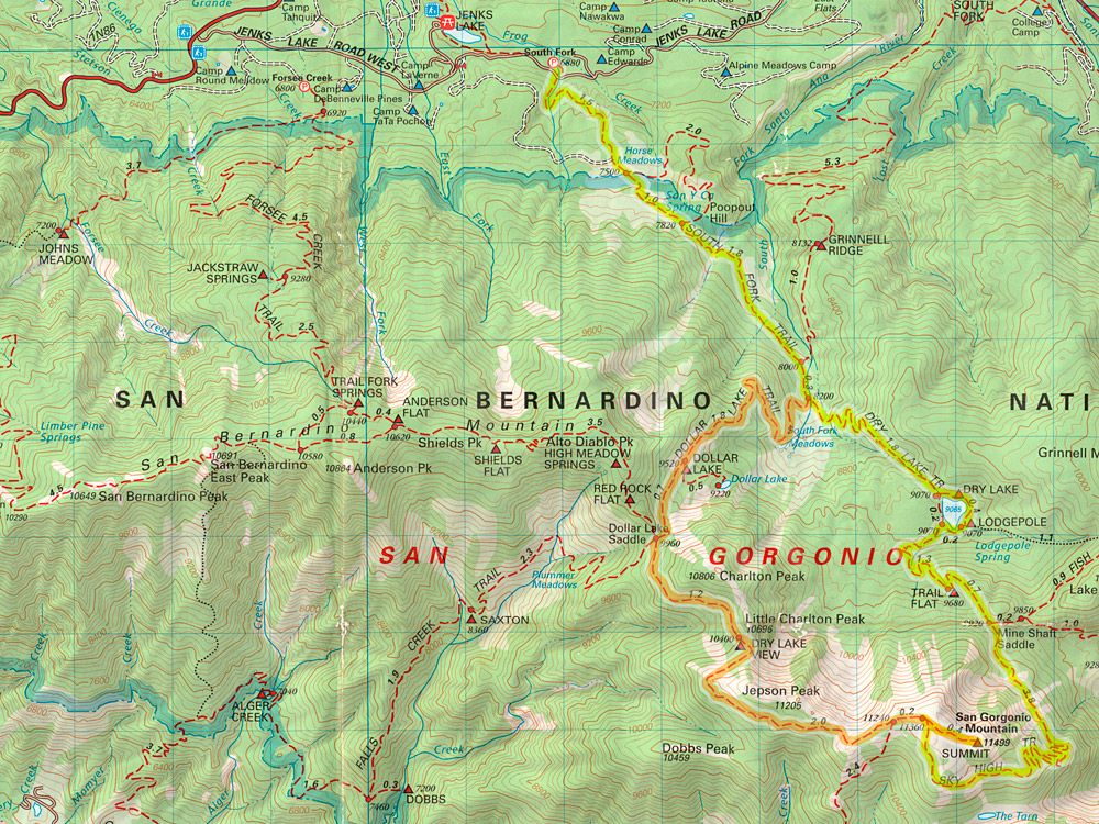
light and move fast. I chose the S. Fork trail for the most inclusive experience - up via Dry Lake, camp the summit, down the Dollar Lake side - the so-called "lollipop" loop (for its shape), approximately 24 miles. To summit via the S. Fork trail, plan on a minimum 7 hours up (13.2 mi.) and 4 hours down (10.9 mi.), depending upon your pace. For my first trip here, I wanted to discover SG at a more relaxed pace and spend time on top and so I decided on an overnight hike. After a 1 3/4 hour drive to the S. Fork trailhead from Los Angeles, I set out at 7am, elevation 6500', temperature a crisp 46 degrees. About 3 hours to Dry Lake, including viewpoint stopover. |
Took
45 minutes to detour to Lodgepole Spring, bag up some water, and take a nice
break. Including a second relaxing 35 minute break for lunch and using
extra caution in the snow, it took about 8.5 hours to reach the summit. A large forest fire 60 miles west had begun that morning (the YorbaLinda/"Freeway Complex" fire), but the Santa Ana winds were blowing the smoke north and west, so the skies were clear. From the summit, you could see the ocean, the Channel Islands and the Salton Sea to the east. At night, the windswept fire threw 300 foot plumes of flame in to the night sky—it was quite a display, even from so far away and so high up. Set out the following morning at 7am, and in a little over 5 hours, including two 10 minute breaks, was back at the car. There was plenty of time to drive around the south side of SGW and get some shots from the valley below. Driving back to LA the following afternoon, the wind had shifted and the entire county was dark with smoke and suit from the fire. |
| The S. Fork to summit
trail is well-maintained and easy to follow–with a few exceptions
in rock fields–and there are signs at all the trail intersections.
With 5000+ feet of elevation gain (and carrying a 30 lb. overnight pack),
I'd consider this a relatively strenous hike due to the steep switchbacks
and thin air at higher elevations. When snow covered, the path on the
switchbacks can be unforgiving if you misstep, but otherwise the S.
Fork trail is a safe, non-technical hike to the summit. Lodgepole Springs, about 1/8 mi. east of Dry Lake, is the last water hole for this summit hike, so carrying 2 days supply from the trailhead isn't necessary. Apparently, Lodgepole flows seasonally, so check first. Camping is permitted at many sites along the trail, which you'll share with horses and bear/deer hunters in season. A bear-proof canister is recommended for all overnight destinations except the summit. Only a limited number of permits are issued for each day and trailhead so plan ahead. Get permits and info from the San Gorgonio Ranger Station in Mill Creek. Check out San Gorgonio Wilderness Association's (sgwa.org) Bulletin Board, for trail conditions and water availability from other hikers. |
Weather here can change
quickly. This mid-November trip had cool mornings and warm afternoons
perfect for hiking, but the nights get cold and conditions can deteriorate
rapidly, so check forecasts and pack accordingly.
The weather held true to the forecast and it was clear skies throughout the weekend under a bright 3/4 moon. Wind was light but infrequent gusts on the summit blew up to 20mph. |
| From the San Fernando
Valley in Los Angeles, take Hwy. 101 east to 134 east to 210 east past
San Bernardino, and Highland, then I-10 east to Redlands - about an
hour and 15 minutes. Exit Orange St./Hwy. 38 and Turn Left (north) under
freeway. After .5 miles, T/R on Hwy 38 east, (aka Lugonia Ave., becomes
Mentone Blvd., becomes Mill Creek Rd.) You could take other exits to reach Hwy. 38, but I think this route is a little easier
to backtrack on the return trip for the LA bound. From the I-10 exit, it's approximately 26 miles on Hwy. 38 up the mountain (stay left at Valley of the Falls Dr.) and T/R Jenks Lake Rd. Trailhead parking is a large, paved lot 2.5 miles on left. Leave nothing that looks valuable visable. Trailhead starts across the road from the restrooms. |
The U.S. Forest Service requires you to buy an Adventure Pass ($5/day, $30/year) and display it on your dashboard when parked and to carry a free Wilderness Permit when entering the San Gorgonio Wilderness (violations "punishable by a fine of not more than $5,000"). At 6 hours out, I crossed paths with a ranger who asked if I had my permit. I'd advise having one. | |
| ||
 One mile up is Horse Meadows, proclaimed to be a historical site. First cabin with a paved courtyard? |
 After two+ miles is a path to a viewpoint which offers the first glimpse of SG's summit. It's worth the detour if you, like me, don't know what the old girl looks like. Apparently, the gnawed sign tastes good also. |
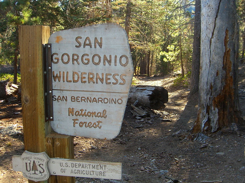 Beyond the viewpoint, you're required to possess a permit to enter the wilderness. Hats off to the designers of these woodsy NFS signs & to those who keep them up and looking good too. |
 |
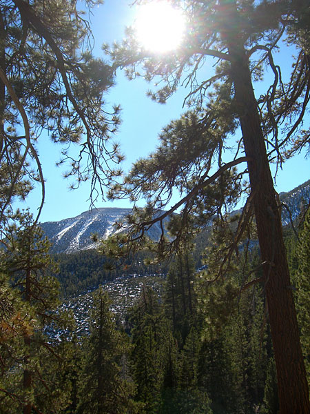
 As the sun climbed into the morning sky, the day started warming up nicely. Jepson Peak. |
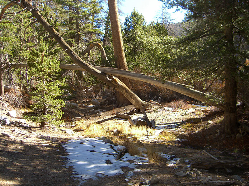
 First look at Dry Lake. |
 Dry Lake, from the northeast, looking southeast to San Gorgonio, left, and Jepson Peak, center. This pic is 5.6 in. x 19.5 in. |
 On the far side of the lake from the trail is Dry Lake camp and this sign for the spring. There's little more than snow for water above here. Sure beats hauling up an entire 2 day supply from the trailhead or messing around melting and filtering snow water. |
 The spring isn't beside the lake. If you didn't know it was back in there, its unlikely you'd stumble across it. Follow a non-distinct trail east almost 1/8th mile from Dry Lake and pass under these trees, (providing they're not cut down...) |
 Not much to look at, Lodgepole seeps out for a few hundred feet then slinks underground again. Bagged up enough H2O for the next 18 hours. |
||
 The trail south from Dry Lake is a little difficult to find.You ascend a gully, then turn west above it, then south again. Soon you break out of the woods into this wide alpine vista, one of my favorite areas of the hike. That's SG on the left. This pic is 4 in. x 21 in. |
 Jepson Peak |
 San Gorgonio summit. The trail was a little sketchy from here up a boulder field. You'll want to go leftish, in an east/southeasterly direction from here. |
 |
||
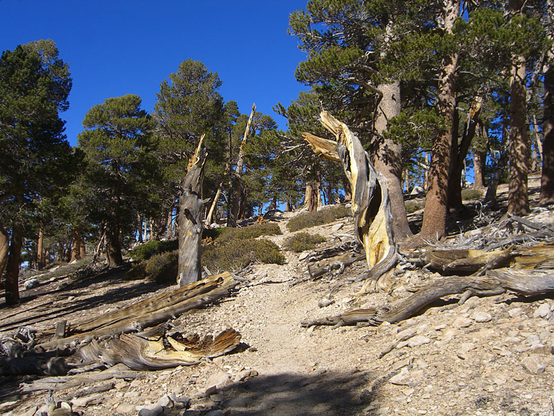
 Massive scruffy trees scrape the sky. |
 A perfect day for experiencing a new wilderness. |
 Trail Flats camp. From here, the trail turns left/northeast and climbs away from the summit in the opposite direction. ;0( Hmmm.... |
 A little frustrating to completely circumnavigate this knoll clockwise before climbing back to the south and SG again. Even the trees seem agitated... |
 Looking back. First tracks up the Dry Lake trail after the snow. |
|
 After a lunch break at the Fish Creek intersection, the trail begins the long circumnavigation
of SG mtn. After a lunch break at the Fish Creek intersection, the trail begins the long circumnavigation
of SG mtn. |
 Snow drifts tend to settle in to the trail, making for slippery and cautious slow-going, walking on the very edge. |
 Southeast toward Little San Bernardino range. |
 Not a good place to miss your step. |
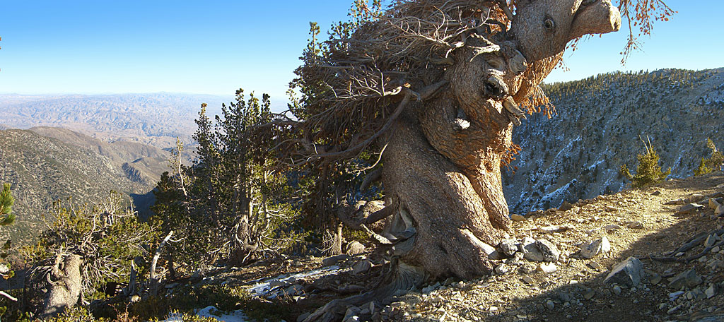 Through sheer audacity, I hereby proclaim this agonizingly twisted and amputated tree to be called "Gargantua" from now until eternity. Look for her on the Southeast switchbacks. |
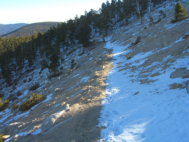
 The snow on the trail clearly marks this set of steep switchbacks you've climbed. This is where you'll want crampons or snowshoes after the next storm blows through. |
 Out of the shadowy north and northeast slopes, the trail is once again clear and dry. |
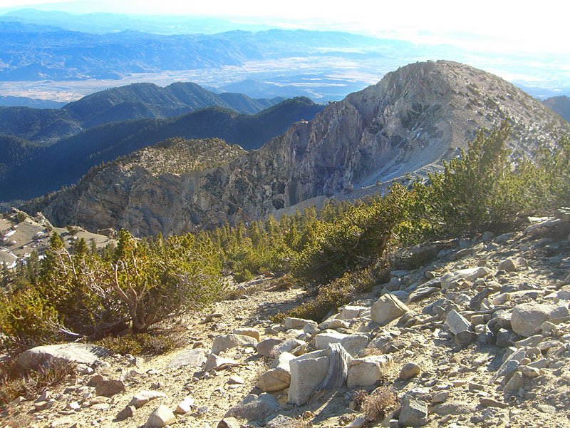
 A wide, seemingly flat, smooth sandy valley at the bottom of this bowl is known as The Tarn. Above it is SG's south summit, with purple Mt. Jacinto across the Banning valley in the distance. |
 Like many California mountains, San Jacinto boasts an impressively steep and craggy valley face. Her backside isn't so imposing. |
 Wanted to hike down to the lip of this giant, rugged bowl for a pic, but was pretty tuckered out after 7+ hours climbing. |
 Finally, after almost completely circling the summit, the trail to the top. |
|
 The summit trail is just a short spur from the main trail, not even an eighth of a mile. |
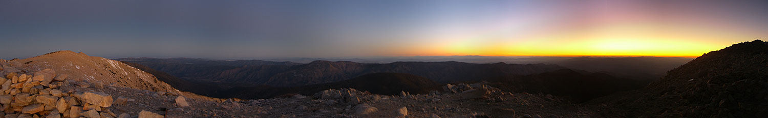
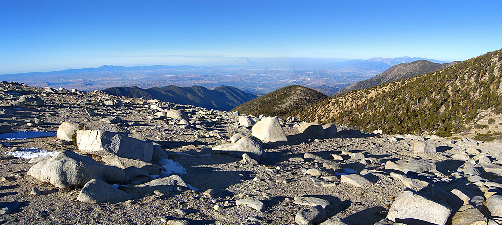
 360 degree panorama from atop San Gorgonio mountain at 4:00pm Nov. 15 2008. Sun is setting in the west, above the Yorba Linda fire. In the bottom center rock pile, you can see a pole marking the purported summit. San Gorgonio has 3 distinct boulder mound summits. I measured the northwest mound, several hundred meters away, as 5 meters higher than this one. Looking south, 10,834' Mt. San Jacinto actually appears taller because of the prominence of its sheer north face above the Banning valley floor. Click here for the big version, 5 in. x 60 in. and 404k |
||||
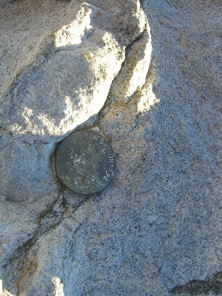 Illegible summit marker reads "1989 GPS, San Gorgonio Peak, 11,501.6 feet, Highest Point So. California." (I had to zoom in on the pic at home to decipher it) |
 This official summit register, a heavy metal box secured in concrete, is a mess. The books are all full and bent up and the box has a bunch of junky stuff in it. |
 This second register, an ammo box secured with a chain nearby, has pens and a clean pad in which you can leave your message. |
 One of the numerous extravagantly built shelters—this one sporting its own shrubbery. There are approximately 9-10 across the summit. The openings all face east and allow rare Santa Ana gusts—like those on my stay—to blow in and catch the tent for a noisy night. |
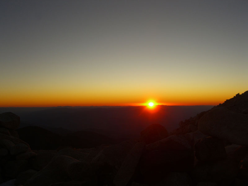
 Panorama northeast and east with peak shadow on the horizon clouds. Sun set at 4:55pm and the temperature dropped rapidly. By 5:30, it was 37 degrees. |
|
 Smoke and giant flames from the raging forest fire make for a dramatic dinner time sunset. A billion stars above and a billion Southland lights below tease from the shimmering blackness. It dropped to 32 overnight, but I was cozy in my tent. |
 San G. summit at dawn. At one point in the night, I sensed a flashlight beam and awoke to voices above the wind. As I listened to them for several moments, I thought to have a look out, maybe say hey, to see who might be brave/foolhardy enough to be setting up a camp on top of this boulder-strewn, windswept carcass in the black night. But then I became unsure what I heard was actually voices, or that I even saw a flashlight. It was too comfy in my warm bag to make a move. Later, a giant 3/4 moon poked me in the eye like a spotlight and woke me up. In the morning, there were no new campers, just me. Then it seemed like maybe the mountain had been playing tricks with my tired mind earlier. Strange how hyper acute but misidentifying ones senses can become in gusty, thin oxygen when night deprives them. Maybe there are spirits wandering the summit... Got plenty of rest and a few bursts of sleep despite regular noisy gusts, then my spot on the planet rotated in to the sun. |
 Muffled gun shots popped from far below in the pre-dawn hours. Hunting season. In no time, the sun emerged from behind the big black shelf to see what was up. |
 The peak shadow points toward the northwest summit mound, which my altimeter declares five meters taller than the purported summit. |
||
 San Gorgonio mountain panorama at 7am with sunrise to the east and peak shadow pointing west to Jepson Peak and the trail back. The Yorba Linda fire was knocked down quite a bit by morning. This pic was shot from the northwest summit. The rocky mound under the sun is the purported summit where I camped. Big Bear Lake can be seen at far right. Click here for the big version, 5 in. tall, 304k. |
|||||
 All three summits are big, jagged piles of rocks, untamed by erosion. |
 Intersection with Vivian Creek trail. |
 Looking north over the lip of ruggedly massive Jepson bowl. |
|||
. Asking myself HOW did these giant boulders get on TOP of the mountain? Thought rocks broke off and went DOWN hill. (...scratches head...Google) |
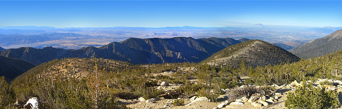
 West towards Orange County. Even with a major Southland Santa Ana fire raging in the distance, San Gorgonio is so big and high that it wasn't even a distraction. |
 Northeast across Jepson bowl. |
 A perfect morning for the hike out. |
||
 Can't get enough of the feeling of height, scale and the solace of wilderness up here. Airplanes fly far below. But it's time to go. Looking west, the ocean and the islands, although not visible with my cheap camera, were easily seen. |
 On these windy slopes, the trees grow twisted and gnarly. |
 Around the north side of Jepson Peak, it got cold again.. |
 Looking west back up the trail on Jepsons north face. |
||
 Around Jepson, the southeast-bound trail T's into a lip above Jepson bowl, then makes a sharp turn west, where it can be a little difficult to follow. |
 Looking west. |
 South to Jepson Peak. You can see the trail you've just descended at upper right, where the 2 shots above were taken. |
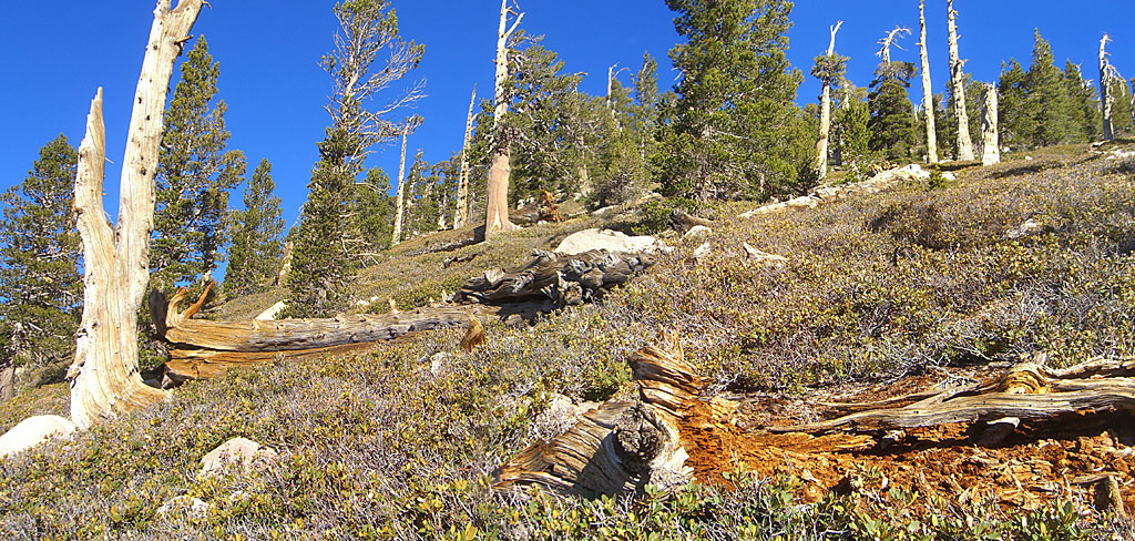 It's a harsh life being a tree way up here, all windy and cold, surrounded by dead and dying relatives. And only a handful of people really appreciate you. |
||
 Campsite at intersection with Plummer Meadows trail and Dollar Lake trail. |
 |
 If I had thick fur, think I'd enjoy living here—except for getting blown away by a high-caliber slug, of course. |
|||
 Dramatic rock cropping above the trail |
 Below Dollar Lake saddle, the trail is steep and switchbacked for miles down to the Dry Lake split. My knee joints were thanking me for using trekking poles. |
 Take in superb views of San Gorgonio through giant lodgepoles and sequoias as the trail seesaws north and south, north and south. |
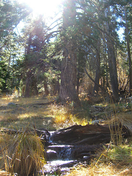 This gurgling stream beside the trail is the first water on the return trip, just above the Dry Lk/Dollar Lk split. |
 A horse and his human were happy to pose for me. |
|
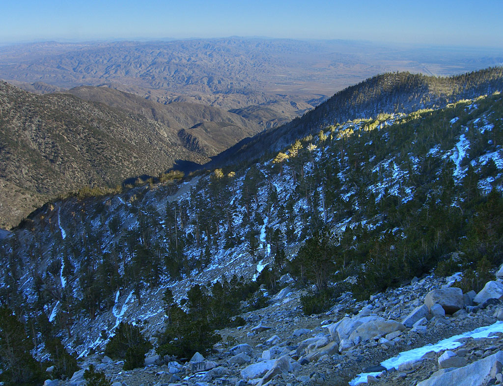
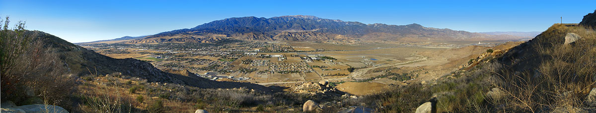 From Hwy. 243, looking north across Banning, CA and Interstate 10 to San Gorgonio mountain. Click here for the big version, (5 in. x 26 in., 250k). |
|||||
Since
12.08
|
|||||
