A fault zone park full of chaotic, tortured rock formations
| Vasquez Rocks, San Gabriel foothills,
Los Angeles county A fault zone park full of chaotic, tortured rock formations |
| Vasquez Rocks Natural
Area is 1.5 square miles of geologic upheaval and rocky hills and canyons
35 miles northeast of LA near the San Andreas fault zone town of Agua
Dulce. Surrounded by the rolling San Gabriel foothills with high peaks
to the south, the park is a colorful and scenic place to take a walk,
climb giant rocks and explore some of the most unusual terrain in the
Southland. The rugged and unique rock formations and web of interconnecting
trails are popular with families, picnickers, hikers, dog-walkers and
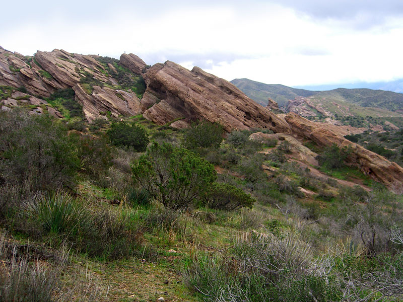
equestrians. The most iconic formation associated with Vasquez Rocks park is the dramatically upturned slab near the entrance, and some visitors explore no further. But there are many more unique discoveries for those who venture into the other parts of the park.  Don't miss the south canyon of the park, where a loop path follows a
seasonal stream through a dramatically formed canyon beneath sandstone
cliffs. There's even a small waterfall after the rains.
Don't miss the south canyon of the park, where a loop path follows a
seasonal stream through a dramatically formed canyon beneath sandstone
cliffs. There's even a small waterfall after the rains. Since the advent of film and television, Vasquez Rocks has been featured in hundreds of productions. With its proximity to Hollywood, the dramatically chaotic landscape has been used as "badlands" in westerns or an alien planet, such as in the original Star Trek TV series' episode "Arena", where Kirk fought the reptilian creature called the Gorn. The tunnel The southern border of the park is busy Hwy. 14, underneath which there is a large, long and dark drainage tunnel you can walk through if you bring a light. The other side is a small canyon beside the highway that leads to a ranch road out. There are a few interesting rock formations, but it doesn't compare with the park side. The tunnel itself is mysteriously interesting as it's curved and you can't see out the other end, but it may have water, silt and debris in it so it isn't particularly inviting. It appears to be relatively new, so it isn't too slimy or smelly. CalTrans probably wouldn't like you in there as it can be slippery and dangerous, but there weren't any posted restrictions on my visit. It seems over-sized for draining an area as small as the park, so I'm guessing it was made big enough to drive through for maintenance. Obviously, this tunnel would be a bad place to be if a logjam burst upstream and a storm of water rolled through. |
Tiburcio Vasquez Vasquez Rocks was named after the notorious bandito Tiburcio Vasquez  ,
who used the rocks as a hideout. Born in 1835, Vasquez was an educated
descendant of California's earliest Spanish settlers, but ran with a
bad crowd that turned to a life of crime. When he was 17, a fight at
a gathering ended in the murder of a lawman and he and his outlaw cousin
fled. Later, caught for horse theft, he spent many years in prison,
but soon after his release, formed a gang and was back on wanted posters
for armed robbery. When the gang murdered 3 people (Vasquez claimed
he didn't do it) during a robbery in central California's San Benito
County, the governor put a large reward on his head. The desperado then
fled to southern California and hid out in the Tejon Pass area and Vasquez
Rocks. He was caught in the San Fernando Valley when a henchman,
angered that Vasquez impregnated a family member, betrayed him. ,
who used the rocks as a hideout. Born in 1835, Vasquez was an educated
descendant of California's earliest Spanish settlers, but ran with a
bad crowd that turned to a life of crime. When he was 17, a fight at
a gathering ended in the murder of a lawman and he and his outlaw cousin
fled. Later, caught for horse theft, he spent many years in prison,
but soon after his release, formed a gang and was back on wanted posters
for armed robbery. When the gang murdered 3 people (Vasquez claimed
he didn't do it) during a robbery in central California's San Benito
County, the governor put a large reward on his head. The desperado then
fled to southern California and hid out in the Tejon Pass area and Vasquez
Rocks. He was caught in the San Fernando Valley when a henchman,
angered that Vasquez impregnated a family member, betrayed him.Vásquez claimed his crimes were the result of racial discrimination, that he was a defender of Mexican-American rights and became a celebrity among many Hispanic Californians. Before he was hanged in 1875 at age 40, Vasquez claimed to have hidden his loot in a hole in the rocks, but he probably didn't have any left. A February hike My winter hike day started cool and overcast with the threat of rain looming - it rained the night before - but after a few hours, sunbursts added a new range of light. The moody weather enhances the drama of the twisted geology and keeps weekend crowds away. The fire-scarred south canyon was reacting to the recent moisture with bursts of greenery so it was ideal weather, really. As you make your way through this strange landscape of jagged rock, it's easy to see why it's the perfect hideout for an outlaw desperado. I packed my usual dayhike stuff: warm extra clothes, rain shell, plenty of water, emergency supplies, a headlamp and lunch. Trekking poles came in handy in the dark tunnel. I spent 4 enjoyable hours hiking the entire park, exploring canyons and cliffs, climbing up numerous giant rock formations, walking through the tunnel and a half mile up the opposite canyon, and lunching atop a rock at the highest point. It was a good workout. If you wanted a quick trip, skipping the southwest hill, and the tunnel and linked canyon, you could see most of the place in 2 hours. I took 4 as I wanted to see and climb on and up everything. Just as I got back to the car, it started raining. |
| Much of the park is
a maze of interconnected dirt footpaths through low chaparral. Pick
an interesting formation and make your way there. It's big enough to
escape the crowds, but not big enough to really get lost as you can
always climb a rock to orient yourself. I estimate maybe 6 miles of hiking to see all the park including the south ridge above Hwy. 14 and the canyon on the other side of the tunnel, but there are many interesting rock formations to discover and climb on within a quarter mile of the parking lot. To access the south canyon trail, go straight/east on the dirt road out of the first parking lot, past the big angled rocks and through the large dirt parking area. Through the steel horse rails, look for the trail southeast across the wide field and up a ridge. On the far side of the ridge is the lower canyon that leads to dramatic cliffs, caves and chaotic rock formations. A trail runs along the seasonal creek that will take you around most of the park and back to the parking lot. It's not hard to find, but here's what I wrote down as I hiked: On the ridge, turn left and follow the trail down. At the bottom is a Y. Turn left/straight, then right along the creek/arroyo trail. |
To check out the tunnel,
at the lowest point of the south canyon where the seasonal creek runs,
follow the creek south toward the highway. The canyon is somewhat overgrown
- stay on the south side of the creek for the best trail. A wildfire burned through the park recently and many of the trees and hills in the south park remain blackened, but regrowth is in full swing. I found the dead trees actually add to the surreal nature of this amazing canyon, but this place won't appeal to everyone. The upside is obscured cliffs, hidden rock formations and vistas are now viewable that never were before.
The park is open most of the year, but be aware the front gate is locked at 5:00pm and there are only a few places to park on the road outside. Check their website for details. There is often snow in the winter and summer temperatures can exceed 100 degrees. There is no drinking water at the park. Between the west side of the park and a residential area, there is an off-limits bird sanctuary. I ended up backtracking around it for some distance. Although the park is bordered by residential neighborhoods, farms and ranches, be aware of indigenous rattlesnakes and a reported mountain lion. |
| Vasquez Rocks Natural
Area is about 35 miles from Los Angeles in northern Los Angeles county. Take I-5 north, go east on Hwy. 14 to Agua Dulce Canyon exit. Turn left/north under the freeway. The road makes a 90 degree right turn after about 1.5 miles. When it makes another 90 degree left hand turn, stay straight on Escondido Cyn. Rd. You'll see the park entrance just ahead on the right. From the freeway, it's about 2 miles to the park entrance. |
|
|
| ||
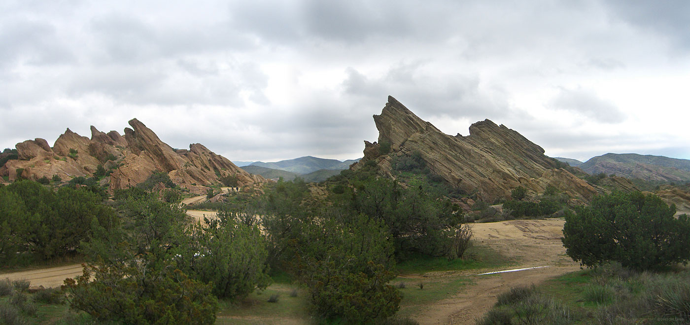 The most famous formation associated with Vasquez Rocks park is the dramatically upturned slab on the right. Looking east from the park entrance |
 Silhouetted hikers (top right) add scale to this rocky hill, just east of the parking lot |
 What part of no don't you understand" |
|||||||
 Looking west. A dirt road and parking area are unfortunately close to this amazing rock formation. |
 East of the famous rock is a large grass field. This southeast to northwest panorama shows the high San Gabriel peaks south of the park |
||||||||
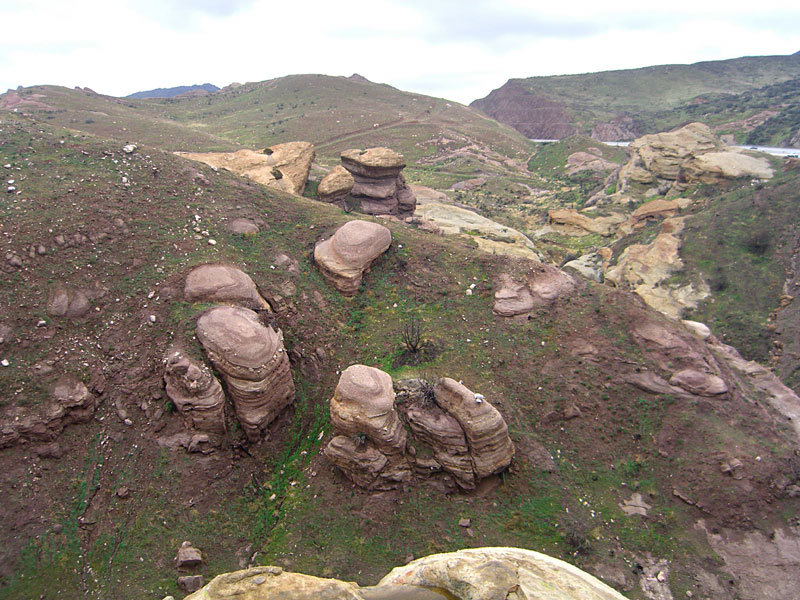
 East from the ridge above the south canyon, the unusual formations begin (or end) suddenly. |
 Along the south canyon |
 This rock could easily be a face in profile - maybe that of Tiburcio Vasquez himself |
 Some hikers taking a break in one of the caves |
||||||
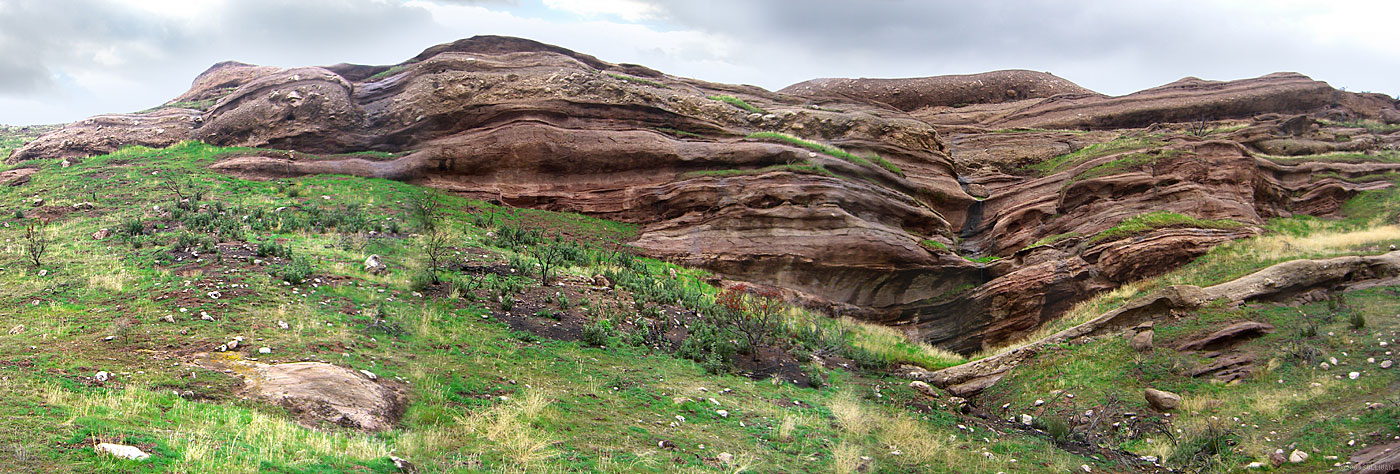
 South canyon panorama east and south. The footpath below this monolithic rock cliff shows the scale. The loop trail turns right/north here back to the park entrance. Through the canyon at right is a tunnel under Hwy. 14 |
 The south end of the park was hardest hit by the fire, but it's making a comeback and green is everywhere.The fire burned many trees, opening up views usually hidden. |
 This natural sculpture on the way to the waterfall seems slightly erotic, or is my mind in the gutter? |
|||||||
 From the trail, you can hear a seasonal waterfall. It takes some off trail climbing to actually see it, trickling down this cliff |
 Minerals in the rock turn the pool beneath the falls a brackish color |
 Looking east at the south canyon I've just climbed out of. |
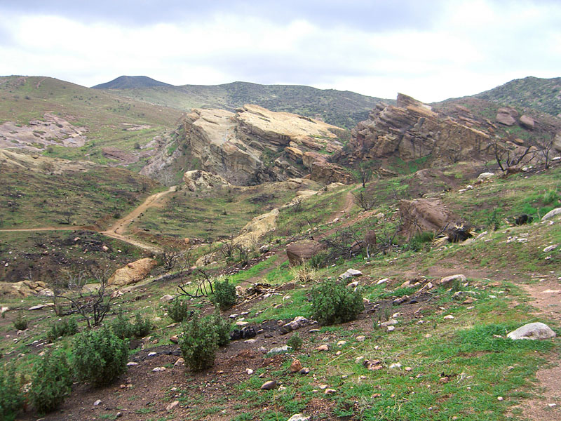
 Looking southeast to the cliffs above the south canyon, with Hwy. 14 at right. The trail up to the right leads to a high southwest ridge. I climbed up to have a look, scout for the tunnel and take a lunch break. |
||||||
 Much of the landscape looks like it was dropped from a great height |
 Looking north from the southwest corner of the park |
 Looking north, the trail in the foreground, a spur off the south canyon trail, climbs this high SW ridge.The trail up to the left climbs to the highest ridge in the park. |
|||||||
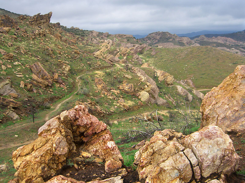
 From the high ridge, I saw the tunnel for the first time. You can gauge it's length by the slant of the embankment |
 View east from the ridge at the southwest corner of the park. Now that I found the tunnel, it was a matter of how to get down there. |
 Not wanting to re-hike the quarter mile back to the canyon trail, I scrambled down a chute (center) from the ledge. |
 It was a little hairy, but do-able. |
 Eroded walls along the tunnel canyon |
|||||
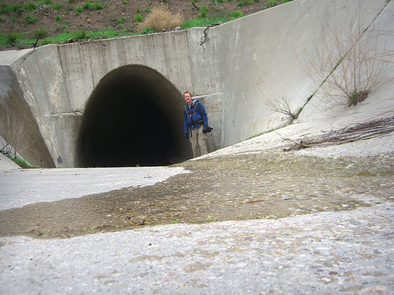 This drainage tunnel is big enough to drive through. There are sidewalk-like ledges on each side but they're not level and too narrow to walk easily on. Still, they beat walking through water. |
 Looking back to the park entrance. Because it's curved, you can't see the far end of the tunnel for several dark minutes |
 After several hundred yards of pitch blackness, the far south end of the tunnel is hardly inviting. A dirt access road leads from here to Agua Dulce road. |
 On the other side of the tunnel, there's another canyon with some interesting rock formations, but nothing to compare to the park side. I don't know if this is private property - there aren't any signs - but someone is using construction equipment to bulldoze a little retreat in an overhang cave there. The highway noise above negates any real enjoyment here. |
||||||
 It's hard to find words to describe this place, but "tortured" seems appropriate. |
 |
 An alien landscape, beautiful with its unique ugliness |
 Last look back at the trail to the tunnel canyon (straight) and to the SW ridge (right) |
||||||
 A landmark north-south ridge on the west side of the park |
 |
 There are many interesting rock formations on the west side. |
 I call this giant head T.Rex |
||||||
 |
 Sunbreaks added to the parks changing moods |
 One of hundreds of caves |
 Vista south with hiker shows the typical maze of interconnected footpaths |
 A toppled stack |
|||||
 I call this one Jaws. From the other side, it's just a pointy rock |
 Hikers atop the rocks |
 Looking south from a high rock, you can see how the stratified layers have been pushed up. When this was all under the ocean, the layers on the west side of the park were high above those on the east. |
 Moody sunset on the way back to LA. The overcast day made for dramatic lighting. |
||||||
| 09.03
|
|||||||||

