Catalina Island from the Trans Catalina Trail

View Trans Catalina Trail in a larger map
Trans Catalina Trail, Santa Catalina Island, Los Angeles county, CaliforniaApr. 13-16, 2010
3 1/2 days, 52+ miles across the length of California's most beautiful island


Overview

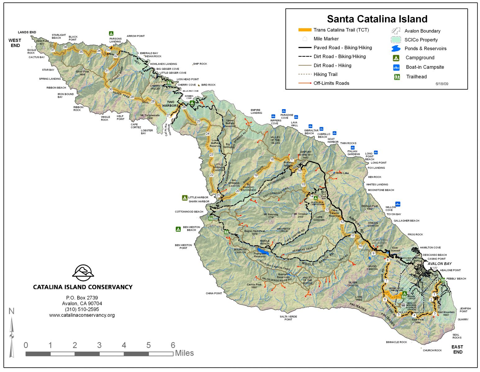
Open for hikers in 2009, the newly finished Trans Catalina Trail (TCT) is poised to become one of the Southland's premiere multi-day hiking destinations. With it's route of challenging mountain ascents, wraparound ocean vistas, lakes and wetlands, palm groves and beaches and year-round accessibility, the TCT is a good workout and an enviable destination. Just 22 miles southwest of Los Angeles, Santa Catalina's proximity to a major metropolis belies the sense of remoteness and the welcome disconnect you feel on an island in the ocean. And the commute on the ferry is a novel beginning and end to your trip. Some detailed planning is required for this hike, as you need not only campground reservations for each night to get your hiking permit, but also ferry reservations to coincide with your hiking dates. Campgrounds fill up early in the year. Check my info section below for details.

The trail designers have purposefully built the TCT to pass through all the island's various ecosystems - mountains, beaches, forests and wetlands - allowing hikers to experience all of Santa Catalina's natural charms. Much of the 37.2 mile TCT follows a network of existing dirt roads, but new trail construction in the central island and connector footpaths in the northwest bring the whole island together. The TCT opens up some sections of Santa Catalina that visitors have rarely if ever seen, including the lush central wetlands and rugged western sea cliffs that are only accessible on foot or horseback.

The TCT criss-crosses Catalina Island from the southeast to the northwest end of the island, passing through the Little Harbor beach campground, Two Harbors village and terminating at remote Starlight Beach on the northeast coast near Land's End. There's no overnight camping at Starlight Beach, so you'll typically backtrack 5-6 miles to Parson's Landing for the night and the next day return the 8-9 miles to Two Harbors via the dirt West End Road for a total of approx. 52 miles that can be done easily in 3-4 days. I got off the trail near Mile 30 and took a different route to Lands End to climb Silver Peak and explore the northwest sea cliffs. The Silver Peak road has some very steep sections and adds a few more miles, but well worth the effort as the hike to Land' s End - one of the highlights of the journey - becomes a loop, eliminating the tedium of retracing the 5-6 miles at the end of the TCT as the builders envisioned. I'd highly recommend it.

South to north across the island
From the town of Avalon in the southeast corner of Santa Catalina, the Trans Catalina Trail climbs to the high ridges above the island's southern shores, offering a full panorama of the lower island, San Clemente island and the SoCal mainland. You can get on the TCT at the Hermit Gulch cutoff if you want to skip the first circuitous 6 miles. From the 360 degree view in the high hills above Avalon, you begin a slow descent to the rolling hills and wetlands of the interior. At remote Little Harbor, the path ascends to soaring heights above rugged western sea cliffs and then drops 1700 feet to Two Harbors, the low-lying isthmus that bisects Catalina Island. The northwestern section climbs high out of Two Harbors to the ridge line near Silver Peak, one of the island's highest, before dropping once again to Parson's Landing beach. The final 5 miles to the end at Starlight Beach will be an out and back trip as there is no overnight camping allowed beyond Parson's Landing. Back at Parson's Landing, you will typically return to Two Harbors via West End Road.

Opening up the island
For most visitors, Santa Catalina island is little more than the resort town of Avalon, or the tranquil beachside community of Two Harbors, as these are the only two developed areas. Daily ferries take visitors across the 22 miles of ocean from the ferry terminal in San Pedro to Avalon or Two Harbors in about an hour. There is a well-developed tourist industry here, a helpful Tourism Office and easy access to visitor information online. Less than 4000 people live on Santa Catalina island year round. You'll probably discover that island life is more relaxed and slower-paced and people are friendlier than you're used to on the mainland. Among other offerings, there is sport fishing and scuba diving, a glass bottom boat excursion, biking, swimming and tennis, a nightclub, shopping and dining. The island is home to large youth summer camps and has numerous facilities for boaters and yachtsmen.
There are few cars and few paved roads on Santa Catalina. Golf carts are the transportation of choice for Avalon residents. Visitors can rent one. Most of the interior is undeveloped and wild, although dirt roads and utility lines mar much of the open spaces. In 2007, devastating wildfires burned miles of land in the mountains above Avalon, but re-growth has been rapid and there is little to show of it. The rugged mountain roads in the northwest are challenging and in spots, extremely dangerous for driving, but visitors can see much of this region in a rollicking Humvee four wheel drive tour out of Two Harbors. Until the TCT, there was no way to see virtually all of Santa Catalina on your own.

History
One of the coastal Channel Islands, Santa Catalina island was inhabited by the Tongva tribe as early as 7000 BC. They mined the soapstone for bowls and implements and traded it along the California coast. The TCT passes several spots where the ancients mined the stone near the airport. Not long after European discovers claimed the island for Spain and Portugal, disease and lack of fresh water lead to the demise of the native population. In the early years of the United States, the island came under the ownership of a string of wealthy entrepreneurs. The Santa Catalina Island Company was formed to develop the island as a resort. In 1919, William Wrigley Jr. - the chewing gum magnate who owned the Chicago Cubs - bought control of the SCIC and began financing the tourism industry in earnest with steamship ferries and building the Catalina Casino. With it's close proximity to Los Angeles and situated in the balmy southern California weather, the mountainous island was found to be the perfect movie set. For one film, bison (buffalo) were imported and before long, a large herd became established - a herd which still roams the island freely today, adding an interesting element of risk to your backcountry adventure.

The Twenties and Thirties were a Golden Age as Santa Catalina gained a reputation as a playground for the rich and famous - attracting celebrities, musicians, politicians, authors, and all of the elite players from Hollywood. With the warm Southern California weather and azure blue waters, Avalon was perfectly situated as a retreat from the booming Los Angeles metropolis. Well-healed visitors came to dance to the top bands, to dine and see the shows. Wrigley's Chicago Cubs practiced here in the off-season. There was big game fishing, boating, gambling, sporting events, diving, swimming and spectator sports.

Fortunes changed with the outbreak of war in the Forties when the military took over the island. Afterwards, cheap air transportation allowed those who could afford it easy access to more exotic destinations in Mexico, Hawaii or the Caribbean. Because of the threat of development, the Wrigley family established the Santa Catalina Island Conservancy (SCIC) in 1971 to preserve the island in its natural condition and promote responsible recreation. As owner of 88 percent of the island, the SCIC maintains control of almost all economic development and has led major efforts into restoring much of the island to it's natural condition.

Trip Report
I'd been jones-ing to hike this trail since I first heard of it opening Spring '09. I was pretty booked into the Sierra and couldn't get out here last year. The final campground on the trail, Parson's Landing, has only has 8 campsite's—all reservable—and they go early in the season. Camping beyond Parson's Landing isn't allowed. Without Parson's Landing to overnight, you'd want to hit the end-of-the-trail segment pretty quick as a Two Harbors to Starlight Beach and back trip, about 22-23 miles (not counting a trip to Land's End) and 2500-3000 feet of elevation gain/drop. I wanted to do the whole trail in an easy-paced hike and also visit "Land's End" - one of the out-stickin'est most points of SoCal.

Land's End
You get to the very western tip of Santa Catalina island by taking the left/NW fork at the Starlight Beach trail/road turnoff. It's about 2+ miles beyond the end of this split and most of it is a climbing scramble-thru-bramble after the road ends and not a maintained trail. There were no restrictions on visiting Land's End dictated other than disturb nothing and don't make them come out there and save you. I had to cancel reservations for a February trip due to rain. The ferry company requires 24 hours for a full refund, but I was told they sometimes make exceptions too.

Spring is the perfect time to visit as Santa Catalina is covered in greenery and flowers galore. But seasonal weather is always a caution on an island in the ocean, even one in balmy southern California, and it's no fun to visit a beautiful spot like this when the skies are choked with clouds, visibility is limited and everything is wet and muddy. I checked the forecasts religiously for this trip, scheduled for a Tuesday through Friday to have as much solitude as possible and grab some nice shots, and lucked out with an accurately forecast clearing trend after several weeks of rain. My Osprey Exos 58 backpack with 3 days of food (4 lbs.) and gear (Tarptent, including a folding saw and 2.5 liters (4.9 lbs.) of water and electrolyte drink, my Nikon D5000 (2.5 lbs.) and my Garmin GPS added up 29.25 pounds I carried. Catalina Express doesn't allow flammables like camping gas on board but they don't ask and don't search your bags. Their list doesn't specifically mention denatured alcohol. You store your luggage on the lower deck with every one elses immediately after boarding but it's not completely off limits should you forget something.

The ferry cost $81.50 roundtrip per person (April '10), 4 days parking was $48, 3 nights camping reservations $48, firewood + extra water 2 nights $24 (at Parson's Landing, extra water and firewood is included in the mandatory $24 reservation), for a total of $201 - not a low budget hike, but not over-the-top either.

All in all, the timing was ideal - the trail and the campgrounds were empty, the weather was a breeze, with a few sun showers to brighten the plants, wash away the grit and add drama to the sky. The island showed off all it's charm. I was hoping for those giant puffy The Simpson's clouds after all the storming, but was satisfied with big sky clearing amidst the coastal front. So my planning paid off, my luck held out and I had the most enjoyable experience on this, my first visit to Catalina Island, that I could've hoped for.
Day 1: San Pedro to Avalon via ferry. TCT trailhead to Blackjack campground
Getting up at 4am for the hour drive to San Pedro, I started waking up in a surprisingly crowded and shadowy pre-dawn rush hour on I-405 out of Santa Monica. It's easy to find the ferry terminal from the 110 south - just look for the Vincent Thomas bridge and get off before it. Rolled down the ramp into the Catalina Terminal dock front for the 6am ferry to Avalon. Several dozen visitors and locals, commuters and work crews, and a hiker, didn't put in a dent in the capacity of this big twin-hulled ferry. We cast off on time, moved out the channel to San Pedro harbor and then into the ocean where they kicked the big engines in. Enroute, sun showers kept most inside and it was too cold to
Early morning along the Avalon waterfront

No BMW's in Avalon - just golf carts and a few 4WD's

Pet cemetary in Avalon
stay out on the decks to enjoy the for the entire trip, but it cleared up nicely upon arrival in Santa Catalina harbor. Avalon has just a small downtown area near the ferry landing, so it was easy to find the Atwater Hotel a few blocks inland, where I got my permit and firewood locker key for Blackjack Campground. Then there's a 2 mile hike up the twisty residential road south of town to the trailhead on top of the mountain. The TCT begins on the Renton Mine road and continues on or beside a dirt fire road the first 13 miles.

There are several miles of mountain to ascend until the trail finally arrives on the high ridgeline above the south side of Catalina. Sun showers started again but there were still nice views south. I was hoping to get a close up of San Clemente island to the south but it was completely shrouded in the marine layer the whole time. By the time
Spring greenery galore in the interior

Site 2, the best spot at empty Blackjack Campground
the trail turned north above Avalon, the sun was out in earnest. I saw my first other hikers around noon at the Hermit's Gulch intersection from Avalon, a shortcut that knocks 6 miles off the beginning of the TCT, but didn't see any others on the trail the rest of the day.

The dirt road takes you through the mountains high above Avalon, much of which burned in the 2007 fires, but all the land was covered in greenery and only a few blackened trees reveal what happened.

Seeing the island from the mountain ridges is a great way to get a feel of how things are situated - where the big peaks are, where the trail goes. You can see that most of the south and southwest is rugged and uninhabited. All along the first 12 miles are great views out over the ocean on both sides. North of Avalon, the trail follows along side the road, but only an occasional truck going toward the airport intruded on the scene. When the sun came out, the color of the water became an unreal shade of blue. I was careful to watch out for rattlesnakes, but didn't come across a single one the entire 3 1/2 day hike.

Arrived at empty Black Jack campground around 5pm on a beautiful evening, with plenty of time to choose the best site (#2 - it's a little more secluded and others don't have to walk through your camp to get to theirs), set up camp, cook dinner and get a nice fire going before dark.

Day 2: Blackjack campground to Two Harbors
Morning started overcast and cool but cleared right away. As the path climbed up around the Airport in the Sky, I passed close by my first wild bull bison. The heads and horns of these shaggy giants are imposingly huge and they have no natural predators here so I was careful to let him know he was in charge! An entire herd of several dozen bison, including bison babies, were grazing on a nearby slope. They all paid careful attention to my progress as the trail brought me closer to where they were gathered. I stopped for breakfast at the airport cafe and picked up some treats for dessert.

The morning heated up rapidly as the trail descends into low-lying drainage in rolling green hills, where there are lots of palms and large ferns
An exhausting climb from Little Harbor behind me, I was looking for some respite. But guess where the trail goes from here?
growing in the shade of giant oaks. The trail builders have re-routed a rather straight hike north into these lowlands to immerse hikers in this unique terrain.

From the heights of the airport, the trail descends west to the sea level campground of Little Harbor, a small sandy cove with dozens of giant old palm trees where I took a lunch break. Only one other person was in this large and remote campground.

The trail north out of Little Harbor starts steeply, then gets even steeper, climbing up to the top of big sea cliffs on the west coast of the island. This rugged coastline is one of the most remote and beautiful sections of Catalina. Flowers everywhere, big birds riding the cool breezes, the vivid blue ocean and the spring greenery of the mountains reminded me of being in Hawaii. This 3 mile stretch of trail north of Little Harbor is my favorite part of the island.

After numerous ups and downs, the trail moves toward the other side of the island and the
This hill is steeper than it looks, with slippery footing - it was hard to stay upright
eastern waters come into view. A final protracted 2 mile descent into Little Harbor marked the end of Day 2's hike and I made it into town pretty beat in the late afternoon sun. I passed only one couple near the airport all day on the trail.

Even though I arrived after 5pm closing time, the nice lady at the Two Harbors Visitor Center stayed open to give me my firewood and water supply locker key for Parson's Landing and then we ended up chatting for quite a while as she imparted her extensive island knowledge and recommendations.

The Two Harbors campground is just south of the village, right on the beach and a hillside above it. There was only one other campsite occupied, so I had my choice. After I set up the tent, I went into town for dinner and a shower at the free and clean town showers. Then I had a nice meal on the restaurant's beach front terrace. Back at camp, a warm fire above the star-filled bay completed an outstanding day.
Day 3: Two Harbors to Silver Peak to Lands End to Starlight Beach to Parsons Landing
After packing up, I hit the local restaurant again for big sit-down breakfast, then made my way across the isthmus to the west side of
Site 36 at Two Harbors Campground - the 2nd best one
Two Harbors, where the TCT begins again at a construction yard and follows a fire road on a steep climb to the mountain tops. The road follows the ridgeline for several miles and gives dramatic views of the deep blue waters in every direction. I wanted to stay on the ridges as much as possible for the views, so when the TCT turned NE beyond Milepost 30 and descended to sea level, I decided to take an alternate route and follow the road to Silver Peak, stay high on the western ridge, and rejoin the trail at the end of the island.

There's a great view of the island from Silver Peak, and I got to see the very northwest tip of Land's End for the first time. I had lunch on top, relaxing in the sun and taking it all in. Silver Peak road to the end of the island is worth the detour. I'm surprised the trail builders re-routed this obvious and more direct looping route to Land's
"Violators will be hung"
End in favor of an out and back path above the north shore. I suppose the route they chose could be considered a little more scenic, as the land around Silver Peak is somewhat eroded and still recovering from generations of over-grazing. On the long descent toward Land's End, there was one section of road that I wouldn't believe could be climbed in a vehicle unless I saw it done. This part of the road is extremely steep and eroded - it would take some advanced 4WD maneuvering skills and plain old luck to pull it off. One wrong slip and you'd end up over the cliff. It was all I could do to stay upright walking with hiking poles and keep from falling down the hill. Even more tiring and demanding on the descent than most ascents.

Land's End
After a very long and slippery descent, I arrived at the intersection with the TCT. Within a mile, the road to Starlight Beach comes up on the right. As you can see from the map (info section), the TCT doesn't go to the end of the island at Land's End, but stops short and descends to Starlight Beach, an elevation drop of almost 500 ft. The road however, continues beyond this intersection. It's only natural to want to explore the tip of the island, so I decided to hit Starlight Beach on the way back. I continued west/northwest for another 1.25 miles
Didn't get to see even one rattler, just this lethargic little king snake
where the road ends at a turnaround. Then there is only 3/4 mile of jagged rocks and cliffs to climb if you want to get to the tip. Following a feint deer trail, I made an effort to climb up along the cliff edge above the surf but a large grove of cactus blocked access. So I scouted another route, backtracked to a faint path I'd seen exit the road earlier, and slowly made my way up again. Through thick scrub and brambles and cactus, I climbed loose rock ledges, scrambling above looming dropoffs down to the crashing surf, and made my way as far northwest to the end of the island as I could safely go. The going was difficult - climbing loose rock and around prickly cactus and in many places I considered turning back, pausing and reconsidering until I scouted an alternate route and continued on. I wouldn't recommend this challenging section unless you're an agile climber with no fear of heights. You'll be glad you have long pants here also.

As I scrambled over the jagged cliff to within a quarter mile of the tip, I could see an exposed high spine at very tip of the land where a pair of bald eagles had made their nest. They were taking turns in the air, but didn't come my way, so I knew I wasn't close enough to present them with a threat. I stayed up on that cliff for an hour into the late afternoon, enjoying the beauty of the moment, the deep
Starlight Beach is the end of the TCT, fitting spot for a self-portrait. Catch the irony of the sign? A "star-lit" beach, but for "day use only"!
blue horizon, the roaring of the surf against the rocks far below, thinking of all the times I'd looked over at this remote cliff perch at the end of this distant island from the Santa Monica mountains so far away and wondering what it was like here where I now sat...

Making my way back to the trail, I started down the steep grade to Starlight Beach. Part way down, I almost turned back as it was a mile-long hill to descend and re-climb just for a quick view of a rocky beach and I'd already put in many miles and lots of elevation. But Starlight Beach is the end of the Trans Catalina Trail and I'd decided I'd be remiss if I were to duck out on completing the entire thing as planned. The road down turned extremely steep and rutted and would be impossible to drive up even in a 4WD truck. Starlight Beach is only accessible via land to someone on foot or horseback and even then, it's a challenging and slippery road. The beach itself is anticlimactic and really about as small, rocky, eroded and unromantic as any beach ever was. So I'd arrived at trails end and then some. Now it was time for the long hike back - 7 miles of steep up's and down's to Parson's Landing before dark.

Parson's Landing
I ran out of water shortly, and was counting on the re-supply to be waiting for me in the locker at Parson's Landing. A beautiful sunset behind me below Land's End and the weather had cleared to offer generous views of the mainland across the ocean. After 2 long and tiring hours, I was finally descending to Parson's Landing beach as the evening light faded. I was relieved to find my key fit one of the beat up locker doors and I had my 2
The road between Starlight Beach and Parson's Landing goes up and down and is tiringly steep
gallons of water and bundle of firewood. Only a young couple at the far end of the campground was here. The girl said a little fox had already made off with a storage bag, but they'd gotten it back.

It was almost dark before I had my tent set up. PL campsites are right on the sand of the beach and I had to use extra tent stays to secure the tent. The sand doesn't hold tent stakes so I had to pile big rocks on each and every stake to keep them from pulling out. After dinner, I struggled to scrounge up enough kindling to set the big logs on fire and was glad I'd brought my folding saw to help. I imagine that most of the year will be impossible to find enough fallen kindling here at Parson's and you'll have to cut it from the big logs - not an easy task. My first well-put together fire start fizzled out from the ocean gusts and I had to begin again. I noticed the fire of the couple down the beach had gone out and they struggled in vain to relight it the rest of the evening! It would be helpful if the Ranger service could provide some kindling with the bundles so people don't cut up all the vegetation around the campgrounds.

Thanks to a splash of stove alcohol, I got my fire going again and eventually was able to relax and enjoy the star-filled sky, the easy surf and the distant lights of Long Beach across the ocean. I stayed up reading until the last log had burned down. A fishing boat with obnoxiously bright krieg lights and loud music arrived just offshore and stayed for an hour. I hoped they would move on to somewhere else and encouraged it with my flashlight. The tiniest little mouse darted back and forth in the pile of rocks, but I didn't leave anything out for him scavenge. Today I'd put in roughly 22 miles and it felt good to sleep on the beach.

Day 4: Parsons Landing to Two Harbors
Morning dawned beautifully. I had a leisurely breakfast then hit the road back. It's probably 8-9 miles back to Two Harbors from Parson's Landing and I need to catch the ferry out at 2:15. I turn off the TCT road onto West End Road, which follows the contours
Arriving back at San Pedro, a deckhand explains these giant freighters arrive full from China, and often return empty.
Couldn't resist this shot at a tight turn in the road above Two Harbors
of every inlet and cove. The ocean is an amazingly azure and clear and the weather is perfect. I pass huge summer camps built into every cove, full of kids swimming and kayaking.

It gets hot quickly on the road and I have to take a break and cool off in the shade. A gorgeous day to end the trip on. I'm back in Two Harbors in plenty of time for a burger lunch.
The trip on the ferry along the east coast back to Avalon is a continued discovery of the island in itself. Back in Avalon, we pick up some passengers and head off across the open water back to San Pedro and home.

Info

Santa Catalina island is 22 miles southwest of Long Beach California in the Channel Islands in Los Angeles county. The 22 mile long island is situated in a NW to SE diagonal with the meridian grid. The city of Avalon and the unicorporated town of Two Harbors are the two population centers on this island. 88% of Catalina Island is owned by the Catalina Island Conservancy, a caretaking organization established by the Wrigley family, the island's long-term owners.

Camping

Most of Santa Catalina island is owned by a private company and camping is allowed only in established campgrounds. Your permit to hike the TCT is your campground reservation(s). There are some exceptions - apparently boaters are allowed to camp on some undeveloped beaches without a permit. Information and online reservations available at visitcatalinaisland.com or by phone. There's a $10 charge for phone reservations but agents can answer your questions or offer advice for free.

There are five established campgrounds on Catalina - Hermit Gulch, Black Jack, Little Harbor, Two Harbors and Parson's Landing. All are very large except Parson's Landing, which has only 8 reservable sites. All campsites have a picnic table and a fire pit. Two Harbors campground also has tent houses that hold large groups. All campgrounds have porta-potties and some have showers. Reservations are $12/night, except Parson's Landing at $24/night which includes a bundle of firewood. There is a 2 night maximum stay. You can buy firewood and additional water ($12) in advance, but make sure to stop by the Visitor Center in Avalon or Two Harbors to pick up your key for the supplies locker at the campground. Rangers stock your bundle of wood and water in these metal lockers in advance then leave the key at the nearest Visitor Center.

Pick up your camping permit and your Blackjack or Little Harbor campground locker key for supplied water and firewood at Atwater Inn in Avalon, 125 Sumner St., 2 blocks in from the waterfront.

Pickup your Parson's Landing locker key at the Two Harbors Visitor Center. This means you'll need to time your Two Harbors arrival or departure to coincide with office hours at the Two Harbors Visitor Center (8am-5pm).

Note that the supplied firewood is a bundle of big slabs of wood and kindling is often unavailable as the campsites have all been scoured of anything that will burn. Although it's generally good seasoned wood that burns well once ignited, you'll need to supply your own dependable firestarter and possibly bring a folding saw to cut kindling, lest you suffer a gloomy fireless night beside a bundle of firewood that you'll have to leave for the next more prepared camper.

Cycling
Bicyclists are allowed on any road, but not on footpath portions of the TCT. In the northwest of the island, there are numerous sections of the road too steep to ride so you'll end up pushing your bike a lot. Like hikers, cyclists need a campground reservation for permission to use the TCT roads for overnight trips.

Map of the Trans Catalina Trail
Ferry service
The main point of disembarcation for regularly scheduled ferry service to Santa Catalina island is the Catalina Terminal below the Vincent Thomas bridge in San Pedro, serviced by Catalina Express or Catalina Cruises. Other ferry service is available from Dana Point or Long Beach Harbor.

From I-405 in Long Beach, take I-110 S., exit Rt. 47 (Terminal Island/ Vincent Thomas Bridge) Do not go over bridge. Exit Harbor Blvd. At stoplight, bottom of ramp, go straight across Harbor Blvd. to Berth 95/Catalina Terminal.

Parking - $12/day 310.547.4357 Take a ticket at entry, pay when you leave. Flammables and/or camping gas are not allowed on the ferry. You can buy it at Safeway in Avalon.

San Pedro to Avalon or Two Harbors currently costs $81.50 per person roundtrip. Reservations are required. Most of the ferries service both Catalina towns before returning to San Pedro and your ticket is good for boarding or disembarking at either location.


Phone numbers
Catalina Express 800.622.2354
Conservancy House - 310.510.2595 / dial 108
Catalina Island Conservancy - 310.510.2595
Catalina Island Chamber of Commerce 310.510.1520
Camping 310.510.8368

Camping reservations: http://www.visitcatalinaisland.com

Pictures

Getting there
Dawn and the Vincent Thomas bridge above the ferry landing in San Pedro.
Giant alien derricks loom above departing seafarer's
Daybreak as we set sail out of Long Beach
Unusual to see the sun rise above a watery horizon in SoCal. A misty marine layer hides the mainland to the East.
Trade winds and April showers create dramatic shafts of light as we leave sight of land
Trade winds and April showers create dramatic shafts of light as we leave sight of land.
Santa Catalina appears, lush and verdant. We steer to the southeast corner and Avalon
Santa Catalina appears, lush and verdant. We steer to the southeast corner and Avalon.
Sun breaks through a misty rain as the ferry arrives in cozy Avalon harbor.
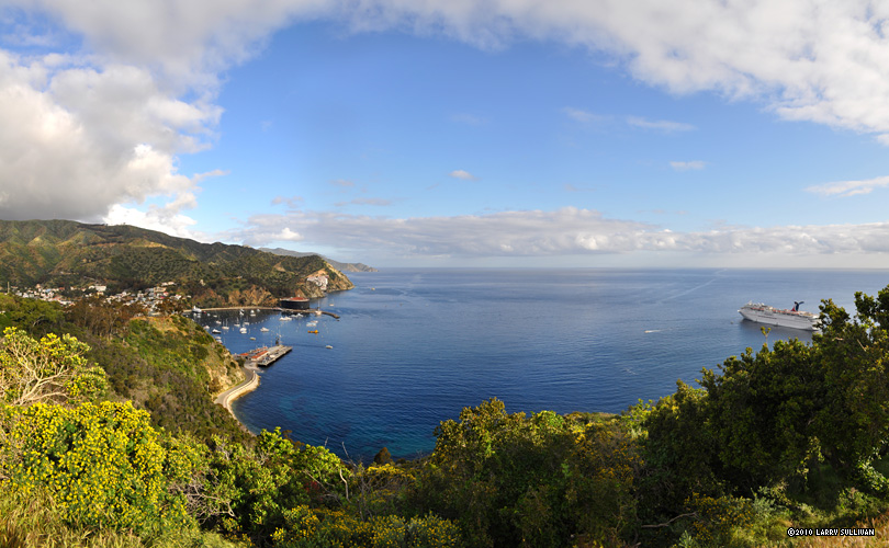
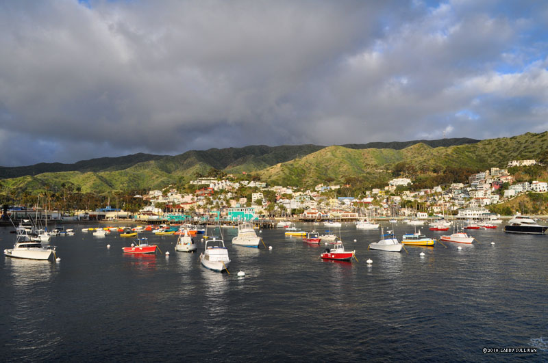
Sun breaks through a misty sprinkle as the ferry arrives in cozy Avalon harbor.
The catamaran ferry can hold hundreds of people
The road above town to the trailhead. The round waterfront Casino is being refurbished.
The sun rally's and the adventure begins
   

The Trail
The beginning of the Trans Catalina Trail high above Avalon.
Renton Mine Rd. climbs to the highest ridges around the south of the island.
This view toward San Clemente island and San Diego was obstructed, but azure waters glisten on the south end of Catalina.
 
Sun showers kept the light interesting as the fire road climbs up, up, up. Then views like this one to the west side opened up.
Looking southeast at Avalon above Hermit's Gulch.
Amazing blue waters in the channel looking east.
Near the Airport in the Sky, the TCT becomes a footpath and descends into the verdant rolling hills and wetlands of the interior
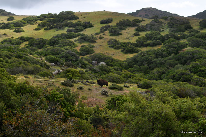
The next morning, a bull buffalo observes me from much closer than it seems
Descending to Little Harbor on the west side of the islandDescending to Little Harbor on the west side of the island Little Harbor is accented by a large grove of old palms. From here, the trail begins a seemingly endless ascent to the sea cliffs in the northwest
Little Harbor is accented by a large grove of old palms. From here, the trail begins a seemingly endless ascent to the sea cliffs in the northwest
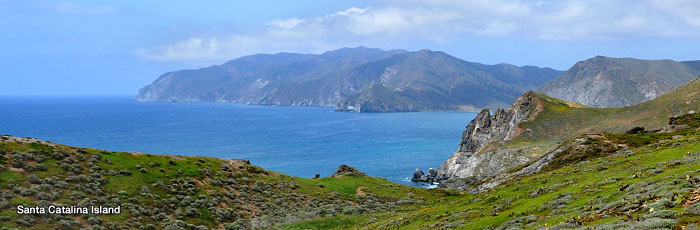
From the top of the mountain, the far end of Catalina appears - rugged, remote and uninhabited
Get a room. Animals!
Vivid blue seas below the rugged northwest corner of Santa Catalina. The distant inlet is the western harbor of Two Harbors.
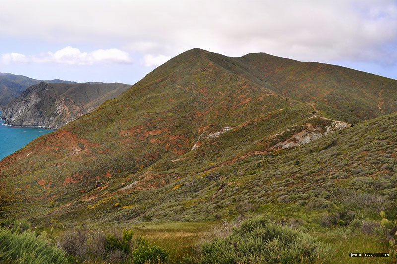
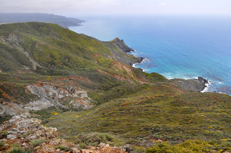
The trail climbs to the highest ridges where the winds gust and views are astounding. Looking southwest back towards Little Harbor beyond the ridge.
The magical northwest end of Santa Catalina island wrapped in lush green California spring colors reminded me of Hawaii.
So many vivid colors, sounds and scents to enjoy in this, the most remote and beautiful part of Santa Catalina.
Finally, a long descent to Two Harbors, where the island is almost split in two.
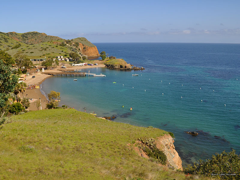
The western harbor of Two Harbors from the east side
Morning - the third - begins once again with a steep ascent.
Morning - the third - begins once again with a steep ascent
Wooden trail posts mark your progress. I decide to leave the TCT - which descends to Starlight Beach in the east. I want to stay in the high country, climb Silver Peak and see the NW end of the island.
North to 1804' Silver Peak, the highest point on west Santa Catalina island
Looking west from Silver Peak and the first view of the very tip of the island
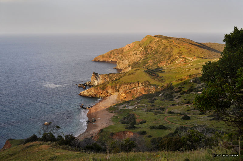
Near Lands End, in the northwest corner of Santa Catalina, this is the view south and east toward the center of the island. East to Los Angeles is left, West to Hawaii at right.
Lands End and the view north at the tip of Santa Catalina island
Last look at the western coast
After circumnavigating the northwest end of the island and descending to Starlight Beach - the end of the trail - I climb back up to the south as the sun sinks into the western sea
Seven miles from Starlight Beach to Parsons Landing follow this winding and often very steep dirt road
Parsons Landing beach on the eastern coast
Parsons Landing beach on the morning of day 4.
Emerald Bay. Miles south along the road back to Two Harbors, many of the coves are home to large summer camps.Emerald Bay. Miles south along the road back to Two Harbors, many of the coves are home to large summer camps. Idyllic coves on the eastern coast of Santa Catalina island
Idyllic coves on the eastern coast of Santa Catalina island
The iconic triangle bench on the West End Road north of Two Harbors
Journey's end. Arriving from the northeast back to Two Harbors, where the ferry back departs

More photos in the Trip Report top of page

TOPHikes Index


Since 10.06