 |
|
| Canyoneering in & around Zion National Park, Utah 5 days climbing in and out of southern Utah's sublime hidden canyons |
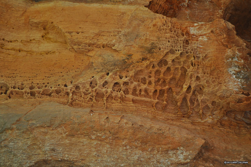
Zion National Park, near Springdale in southern Utah, is one of the countries most popular parks. Each year, over 2 million visitors from around the world are drawn to the deep canyons with sheer red cliffs soaring thousands of feet above a lush, green valley. The Virgin River has sculpted a magnificent landscape with fascinating rock formations. Once situated under the ocean, this part of the Colorado Plateau is characterized by water-formed desert geology and multi-layered sandstone called slickrock. In addition to cycling and rafting, miles of well-maintained trails offer panoramic vistas to every level of hiker. But hidden from view, there are myriad secretive canyons, wondrous subterranean passageways and exquisitely formed chambers filled with magical light, at times directly under popular areas and unknown to the casual visitors above. These are the realms of the canyoneer! Canyoneering Canyoneering is the sport of hiking and exploring canyons using technical
In addition to safe techniques and best practices, there are many things to learn about climbing and backcountry ethics when canyoneering. The best way to get started is to find an experienced teacher or join up with a professional organization. This is a sport that requires teamwork and typically, canyoneering groups number 3 to 5 people for safety and logistics. |
By some estimates, over half of Zions canyons are considered technical or semi-technical. Along with the sublime beauty of these ancient slot canyons comes the risk of adventuring in to a remote wilderness where there is no cell-phone signal, rescue can be days away or non-existant, and danger awaits the ignorant and unprepared.
This eliminates them as a destination for the majority of visitors, but backcountry canyoneering has become so popular, leading to several tragedies, that a quota system was instituted allowing access to limited numbers of hikers each day. All canyons where a rope is necessary in Zion National Park now require a permit, even for a short dayhike. The area outside the park, however, has many extraordinary canyons that don't require a permit. There are several outfitters around Zion that offer instruction and trips to these outlying canyons. Canyoneering is not an "extreme" sport, but it's not without risk. When done correctly with preparation and planning by competent, equipped and informed participants, it's very safe. Canyoneers get the exhilaration of exploring some of the worlds most fascinating terrain - unavailable to any other. The canyons explored this trip: Birch Hollow Keyhole Canyon Pine Creek Canyon Left fork of North Creek / The Subway Lower Refrigerator Canyon Behunin Canyon |

During my last hiking trip to Zion in September 2009, I learned about the spectacular hidden canyons here that required ropes to explore. I had no technical experience, but I decided that on my next trip here, I'd be prepared. I had to see them!
A few weeks before my trip, I got lucky and received a note from Rick T., an experienced canyoneering group leader from Salt Lake City, whose rafting trip fell through and now had a week free to do Zion. Rick is the consumate canyoneer, an excellent climber and canyoneering leader of the Wasatch Mountain Club, a venerable Utah outdoors club. He has years of experience leading groups into almost every Zion canyon and throughout Utah and environs.
Next I bought a harness, belay device, helmet and got some experience rappelling with some friends locally. Finally, I splurged on sticky-soled canyoneering shoes and a wetsuit, rather than rent them. On Sunday June 12, I drove the 440 miles from LA to Zion in about 7 hours. The park's campgrounds always fill up early in the day, so I found a spot to camp a few miles outside Rockville at the Coal Pits wash area, a Bureau of Land Mgmt. (BLM) property. It's free to camp for 2 weeks on any BLM property, so you can expect all sorts of uncontrolled behavior from every kind of person here. In the morning, I found a large site at Zion's South campground suitable for a group, and hooked up with Rick and two others - his nephew Brandon and wife Carrie from Idaho, both with some experience rappelling who were tough, natural hikers and rafting enthusiasts. We'd spend 3 of the next 4 days canyoneering together as a group and by the last day, the four of us had started working like a team, watching out for each other, managing the ropes. They graciously didn't splash me when I had my camera out. Rick always led on the trail, set up the anchors, monitored our rappeling and was the last down. I usually went first so that I could get some nice pictures. We took turns belaying each other on the big drops. Brandon and Carrie left on Thursday night, and on Friday morning, we were joined by experienced canyoneers Tim & Gina R., and Tim P., all from Salt Lake City, who had been on outings with Rick before. We begin each day with what will become our morning routine, queueing at the Backcountry window of the nearby Zion Visitor Center to secure permits for the following day. Walk-in permits are only available one day in advance, or the day of the hike, if any are left. This line often has an interesting mix of canyoneering veterans and newcomers, most of whom are looking to score the 20 walk-in permits to the Subway available each morning. 40 other reservable Subway permits for each day are won in the Lottery months earlier. (I have two reservations I won long ago for Wednesdays's hike.) One person can take 12 of the 20 for his group. On the first day, there are about 15 people waiting for the window to open. When the Ranger arrives at 8:30, the first person in line - who's been here since 4am, I find out - takes 12 permits for his group. The second guy takes 8. Everyone groans and leaves.. |


| Day 1: Birch Hollow | ||
|

| Day 2: Keyhole canyon, Pine Creek canyon | ||||||||||||||||
|
||||||||||||||||
I learned a lot about technical climbing on this trip. And about my own preconceived limitations - how big a drop is too big, etc. (Our biggest drop was 190 feet!) The one thing I learned that stood out among all the others is that having an experienced and accomplished group leader is the key to an enjoyable experience vs. an ordeal. These canyoneering adventures involved taking big leaps of faith that the anchors are secure, the ropes are in good condition (and long enough!), that we have the gear and skills to get out in an emergency, that we bring wetsuits to the canyons that need them, etc. There's a lot of pressure on the group leader who brings untested strangers into the canyons to keep it fun. Canyoneering adds many variables - e.g., the importance of weather and conditions, new obstacles that have appeared over the winter, pulling the ropes and bringing the right gear - that add to the effort of hiking in the wilderness. It's especially nice to safely run these canyons without having to know everything, and just be able to enjoy the moment. So a big thank you to Rick, our fearless leader! Now I'm addicted. I want to come back and do the more challenging Zion canyons like Imlay and Heaps, and others in the vicinity. The entire Colorado Plateau is a smorgasbord of canyoneering adventure. I'll certainly be joining the American Canyoneering Association to find some more of this closer to home. Hanging from ropes over cliffs isn't for everyone, but if you miss these exquisite, hidden canyons, you miss experiencing the most memorable parts of Zion. |


The main Zion canyon is closed to cars. All visitors park in the large Visitor Center parking lot and take free articulated shuttle buses, which run every few minutes and stop at every stop. This parking lot fills up by noon each day, so overflow lots are available throughout Springdale. Free shuttle buses run a regular schedule from Springdale to the Visitor Center. Guests of Zion Lodge are allowed to drive in the main canyon as far as Zion Lodge, but you must display a guest pass. Springdale is a small but lively tree-lined town along the Virgin River, with many motels, good restaurants, shopping centers, 2 decent grocery stores, banks, outfitters and a theater. If you can't find it in Springdale or Rockville, there's a Walmart in Hurricane. My favorite places to eat were Oscars Cafe and Pizza & Noodle Company. Camping There are 2 very large public campgrounds in the park - Watchman Campground and South Campground, both near the parks southern entrance. Watchman spaces are completely reservable, while South is completely first come, first served. I've found that it's not difficult to get a space at South, even during a busy weekend, if you arrive at 7:30-8:30am. Prices in June 2011 are $16 a night per site. You're allowed up to 3 small tents per site, but only 2 vehicles. There are numerous bathrooms with cold-water sinks, mirrors and flush toilets. There are taps for fresh drinking water near the bathrooms. You can get a shower in Springdale - see info at right. There is also dispersed camping on Bureau of Land Management (BLM) - a federal government agency - property at the Coal Pits Wash, a signed pull-out on the north side of Hwy. 9, 2 miles west of Rockville. Two weeks of free camping is allowed on all BLM property, but expect unregulated, festival-type behavior. The Wash is only a trickle -bring your own water. Across the highway on the south side, a dirt road leads to another less-known public campsite, big enough for a group. The BLM owns a sliver of property on both sides of the Wash and along the Virgin, although the surrounding land is private. A 4WD is recommended to go down into the deep sand there. Permits Zion has a far-reaching permit system governing backcountry hiking. Permits are required from the Zion Backcountry Ranger office, located in the Visitor Center, for all overnight hiking and for every canyon requiring ropes during the 3 most visited seasons. Permits can be reserved online months in advance, and some are held for walk-in visitors too. The NPS website has extensive information on every Zion hike so you can plan your backcountry visits months beforehand. It would be wise to join up with an experienced group for your first backcountry canyoneering trip. Guiding for hire is not allowed in Zion National Park, but the surrounding areas are unregulated. |
Planning |

| Around Zion | |||||
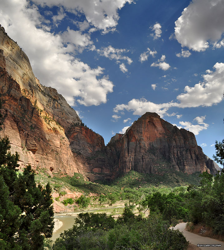 Zion National Park is a canyon land formed by the power of water, with sheer vertical walls and deep, twisted slot canyons. |
 The Virgin River flows through the center of the park, benign and idyllic. But flash floods can turn it into a raging torrent of mud and debris. |
 Over millenia, the river has scoured and carved the red rock in to majestic landscapes. |
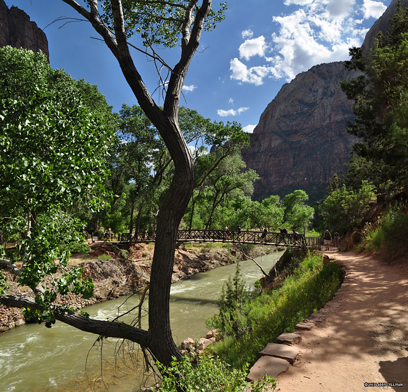 The bridge at the Grotto bus stop is the beginning of the West Rim trail to Angel's Landing. |
 The Virgin River is running higher and faster in 2011 than usual due to a record wet winter and snow accumulation. |
 Colors of dusk transform the river from its customary reddish brown hue. |
 Sunset in Zion |
 Pasture at dusk in Springdale |
 Restored buildings at Grafton ghost town |
|||
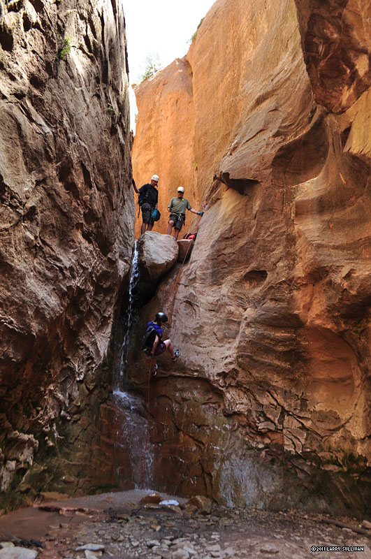
Day 1 - Birch Hollow __________________________________________________________________________________________________________________ |
||||
 The streambed we're scrambling down ends at this 80 ft. waterfall. We take a steep path around to here. |
 Once in the stone canyon, this is our first rappel. The water spray was refreshing in the hot sun. Birch Hollow is usually dry, but it was a wet winter. |
 Making our way down canyon, the high walls provide relief from the hot sun. |
 We rapped several obstacles that the more experienced might down-climb. |
 The chockstone adds a unique touch to this last rap in Birch Hollow. Then, a long hike out in the hot sun. |
 Another careful descent over slippery rocks in to a pool |
 A 75 ft. drop down a slick half-tube is the halfway point for this rap... |
 ...which finishes in another pool. You can see the top half-tube behind the peops. |
 Avoiding slipping and banging your elbows and knees is difficult |
|
 Another short drop in to another pool |
 Climb over a boulder, avoid a slippery tree, in to a pool. |
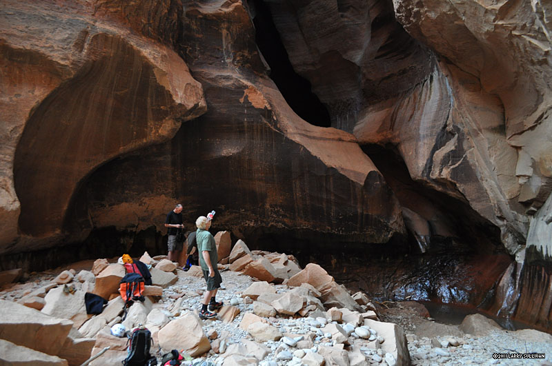
 Drop through a warped, water-carved cavern |
||
Day 2, am- Keyhole Canyon __________________________________________________________________________________________________________________ |
||||
 Climbing in to Keyhole Canyon, Zion National Park, Utah June 2011 |
 Keyhole begins with a short steep climb up the slickrock from Highway 9. |
 Then a butt-scraping scramble down a vertical trail of loose dirt and slippery rock to the stone canyon entrance. |
 Keyhole is an all too brief water-filled slot. Time to don our wetsuits. |
 Colorful light in Keyhole Canyon, Zion National Park |
 After some swimming, this hallway of light |
 As clouds pass overhead, the light flickers and fades. |
 FInishing off Keyhole with a cooling passage under the highway. |
||
| Day 2, pm- Pine Creek canyon | ||||||
 After lunch at the car nearby, still in our wetsuits, the quick descent into Pine Creek Canyon starts with a splash. |
 From moment to moment, from corridor to corridor, the light changes moods. |
 Wading in murky waist deep water with an expensive DSLR is risky but rewarding. |
 The Cathedral of Pine Creek canyon. |
 |
||
 Each bend in the canyon walls rewards us with more sublime light. My neck ached from gaping upwards. |
 Rarely in direct sunlight, the cool canyon sometimes opens up to glimpses of the hot landscape above. |
. Finally we exit the slot onto a plateau high above the canyon floor, beneath sheer vertical walls |
||||
 Making our way down giant boulders to our final 2 raps. |
 The last drop at Pine Creek has an awkward entry that requires squatting and launching sideways into the abyss. A few steps on rock - then 100 ft of air!. |
 The previous group finishes down below as we drop in. |
 How much water would it take to carve this hole? |
 There's gurgling spring at the bottom. We strip off our wetsuits, bag our ropes and have a snack. |
|
 We pace ourselves to give the previous group plenty of space |
 Rick glides down the final 100 footer at Pine Creek canyon. |
 There's still an hour of tricky scrambling down canyon in the hot sun, not without mishap, to get out. |
|||
 A big free rap like this is much more challenging when you're thoroughly chilled after hours in the cool, wet canyon. |
 Our Pine Creek journey ends with a rewarding splash at the swimming hole at the bottom. |
||||
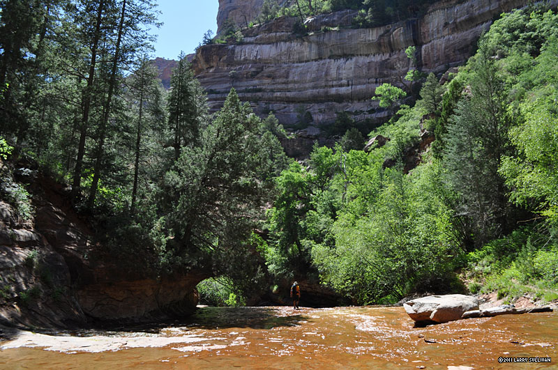
Day 3 - Left fork of North Creek - the Subway, from the "top down" __________________________________________________________________________________________________________________ |
|||||
 Two miles in, this panorama south and east as we exit a pine forest and cross a slickrock landscape. |
 A cliff edge perch offers this view down into Russell Gulch and North Creek, which we'll descend to at right via a steep vertical trail. |
 Once down on the water, we climb through unique rock formations and through icy pools. |
 Around every bend are intriguing new shapes and colors. |
 Much of the hike is in the creek bed itself, made easier with our special water shoes. |
|
 New obstacles from the record flooding of Winter 2010 are now lodged in the narrow channel that holds Keyhole Falls. |
 The Keyhole and Keyhole Falls of North Creek |
 The lower canyon walls begin to take on a distinctive tubular shape. |
 The play of light and shadows in these deep canyons is a feast for the eyes. |
 It helps to add human scale to appreciate this chasm of stone |
 A tree lodged in the watercourse is an icon of the Subway |
 Although there were 60 others permitted in this canyon today, we had this magical place completely to ourselves until the end of the day. |
 It's easy to stand in this remote canyon in the wilderness, listening to the wind in the trees, the birds and the water, and imagine you are the first ever to experience it. |
 I brought my wetsuit after seeing big water images on the park website, but the water was low and slow, as Rick predicted. I didn't take it out of my pack. |
 By early afternoon, we must be close. Every bend adds to the anticipation. |
 Finally, we arrive at the iconic Subway scene. We were lucky to get the full sun on these pools as the light changes dramatically from hour to hour |
 This ledge prevents "bottom-up" Subway hikers from continuing up stream without a rope. |
 The famous pools and curved wall of Zion's "Subway" |
 The Subway, Zion National Park, Utah It was a thrill to have this magical garden of stone and water completely to ourselves. This 180 degree pano is a compilation of 6 images. |
 In contrast to its noisy, dirty urban namesake, this Subway is a truly special place, one of the most wondrous natural creations I've seen. |
 These parallel crevices could be interpreted as the "tracks" of the Subway |
||
 High canyon walls keep people both in and out of the the Left Fork of North Creek. You can see Rick in the shadows bottom right. |
 Cascade below the Subway |
 After this wide stretch of open water, the creek bed becomes choked with giant boulders, landslides and overgrowth. Much of the remaining 4 miles are scrambling, boulder-hopping and route-finding. Then, a final strenuous climb to the rim and we're out. |
|||
Day 4 - Lower Refrigerator canyon __________________________________________________________________________________________________________________ |
|||||
 The route to LR follows the West Rim trail to Angel's Landing - one of the most popular hikes in Zion. It starts with a steep climb up the face of this cliff. |
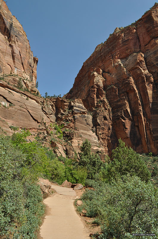 LR is a short but sheer vertical drop out of the right side of the saddle in the center. It's difficult to gauge how big and steep the climb is from a photo. |
 Starting up the face, you can see the verticality of the walls we'll soon be rappelling down. |
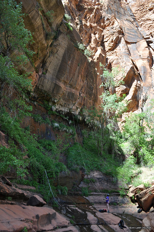
 From the bridge over Refrigerator Creek, this is the view into the narrow crevice where we begin. LR is a rather new route yet to be listed by the Park Service. |
 Staying discretely quiet to discourage the unprepared from following us, we make our way to the exposed precipice. |
 We can't see the ledges we'll need to land on. It's a long way down! We can't see the ledges we'll need to land on. It's a long way down! |
 After some tricky maneuvering, we land on a platform 400 feet up with this sweeping view. Then come long moments strategizing our drop to a tiny exposed ledge halfway down that has room only for 3 of us. |
 Back on solid ground after the final rap, belaying for the next to appear over the edge. |
 The verticality of this rugged face adds to the drama of a challenging rappel. |
 The last rap at Lower Refrigerator |
 Our fearless leader Rick making it look easy. |
 Watch out for the poison ivy at the bottom! Watch out for the poison ivy at the bottom! |
 The big adrenaline surge slowly dissipates on the scramble back to the trail. |
 Now it's just another walk in the park back to the shuttle bus and camp, but it feels hard to blend in among the tourists on the bus after such a rush! |
||||


More photos in the Trip Report top of page
TOP![]() Hikes Index
Hikes Index
Since 10.06