 |
|
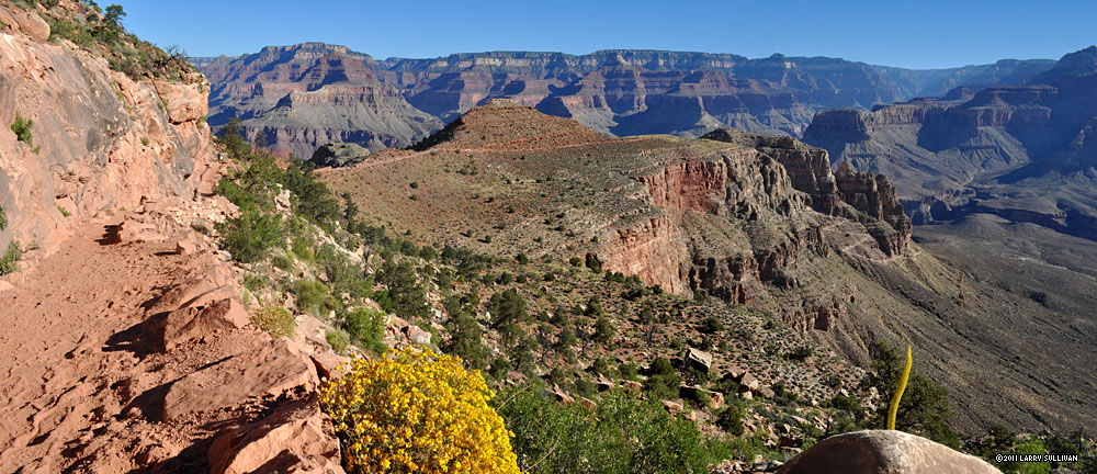
| Grand Canyon National Park, Arizona South Rim to river via South Kaibab and Bright Angel trails- a strenuous but rewarding 16.5 mile roundtrip |
Overview
| The Grand Canyon of the Colorado River is one of the most legendary destinations in the world. The numbers are impressive: 277 river miles long, up to 18 miles wide, 1 mile deep, covering 1.2 million acres, created over 6 millions years. The Grand Canyon is so big that deciding where to go can be a challenge. The North Rim is just a dozen miles across the canyon from the South Rim, but hundreds of miles away by car, which usually means deciding to see either one or the other per visit. For the casual explorer, the obvious choice to begin is the easily accessible South Rim, which has Desert View visitor center, Grand Canyon visitor center, Grand Canyon Village and a well-developed infrastructure of accomodations, visitor concessions and free transportation, as well as epic vistas. Historically, the South Rim has been the epicenter of Grand Canyon tourism for over 100 years. Next, I needed the classic South Rim hiking experience. That was also easy - a rim to river (R2R) and back hike immerses you in a variety of terrain and vegetation and takes you to the main event of the Grand Canyon -the river that carved it. Hiking to the Colorado River and back from one vertical mile above is an ambitious undertaking, and the perfect focal point to a Grand Canyon hiking trip. And so the decision was made to hike to Bright Angel campground from the South Rim, and back, going down the South Kaibab (pronounced KI bab) trail, and returning on the Bright Angel trail, to make a nice loop out of it. Getting an early start to beat the heat is the essential ingredient of Grand Canyon summer backpacking. Park literature recommends resting in the shade between 10am-4pm, the peak heat hours. Of course this takes away most of the light of day. It's wise to take this advice to heart, as it gets hotter as you drop to the river - much hotter, up to 15 degrees hotter! |
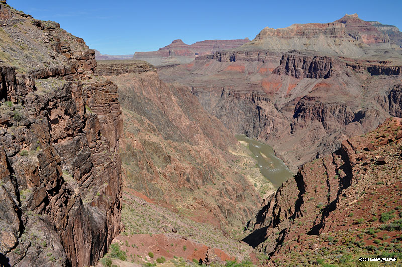
John Wesley Powell's 1869 expedition found clear water entering the muddy Colorado here and later gave it the name Bright Angel creek. Two steel suspension bridges serve Bright Angel - the South Kaibab bridge which serves its namesake trail, and the Silver Bridge, which carries the Bright Angel trail. Bright Angel is only used by hikers, whereas South Kaibab is the trail used by mules to haul tourists and supplies, and the bridge is lined with heavy wooden planks. Aside from a R2R roundtrip, what other Grand Canyon backcountry adventures beckon? I'd hoped to visit Havasu Falls, on Havasu Indian land at the western end of the Grand Canyon. But permit reservations require speaking to a native agent on the phone and noone answered after one dozen tries over a two week span. I assumed it was closed after a historically harsh rainy season. Finally, when I did get through, I was told the season was sold out. You're probably not going to want to do more than one strenuous R2R per trip, unless you have thighs and calves of steel. There's plenty of exploring along the length of the rim, but honestly, after a few dayhikes/bike rides, the shape of the terrain seems to be very similar from everywhere. Most of the non-canyon flat lands at the top is covered with thick forest or desert, with limited potential for discovering unique vistas. It's not difficult to spend hours gazing across the canyon, watching the giant walls reflect the changing atmospheric conditions, and the variety of colors, shadows and play of light. The dilemma for backcountry hikers at the Grand Canyon is that almost all of the overnight treks involve steep descents coupled with strenuous ascents. I'll wrap up this intro with that observation, that I have yet to discover my next Grand Canyon backcountry adventure. It may well be an exploration of the more ruggedly remote North Rim, or maybe a river rafting trip, but that might belong to another category all together. |
Trip Report
|
|||||
| Day 1: South Rim to Bright Angel campground on the South Kaibab trail | |||||
|
|||||
|

Info
Grand Canyon National Park is divided in to two sections for tourism.The South Rim is open 24 hours a day, 365 days a year. The North Rim is open mid-May to mid-October. |
General Visitor Information: 928.638.7888 Backcountry Information Center: 928.638.7875 1-5 pm Mon.-Fri. Camping reservations: www.recreation.gov South Rim camping: Mather Campground is reservable. $18/night Desert View campground is first-come, first-served. Camping "at-large" is permitted in the national forest outside the park. |

Pictures
| Getting there | |||||||||
 Sunset at Horseshoe Bend near Page AZ. It's 1000 ft. down to the Colorado River |
 The Grand Canyon of the Colorado River from the east side of the South Rim. The river runs east (right) to west (left) in the center. |
 The rustic Watchtower at Desert View visitor center was finished in 1932. |
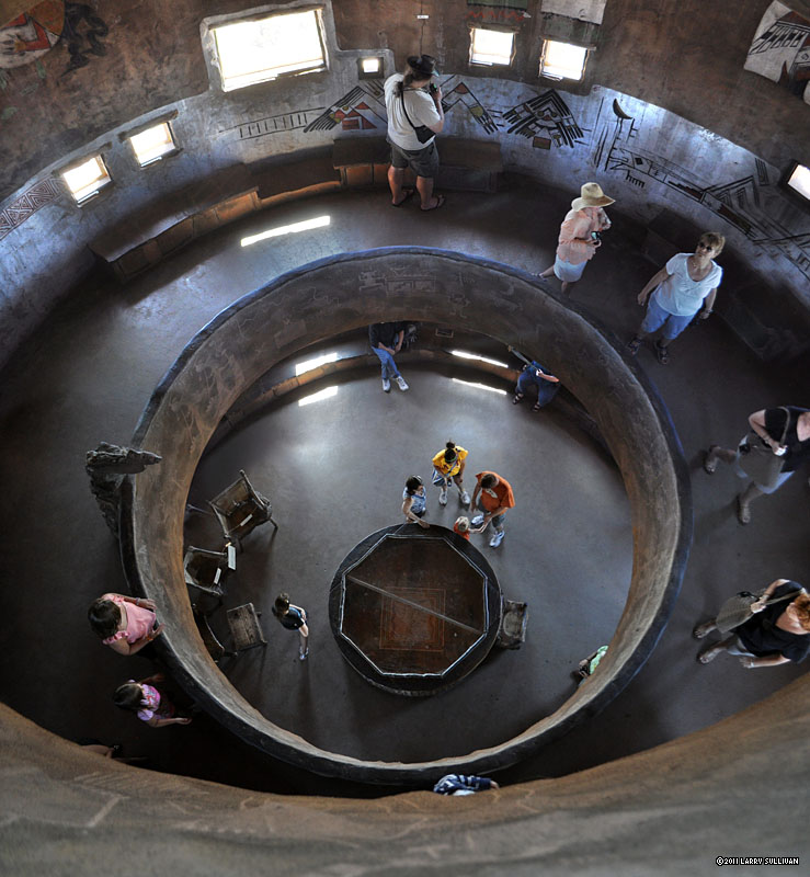 The interior is decorated with native art and murals. |
||||||
 View west from Moran Point |
 Mule deer are large and in charge. They have no fear of humans or cars and wander nonchalantly through populated areas... |
 ...Apparently they haven't been reading the sign. |
 Grandview Point, Grand Canyon National Park, Arizona |
||
On the trail |
|||||
 Starting down the S. Kaibab trail at Yaki Point. It's 7 miles to the river. |
 On the way down, I chat with an interpretive Ranger, who's commuting to her job - a week at Phantom Ranch. Perfect weather. It's often hazy, she says. |
 Coming off the rim, the trail is steep switchbacks and slippery, then levels out crossing a plateau. O'Neill Butte at right and the North Rim beyond. |
 There are quite a few day hikers on the trail, making an early down-and-back to one of the river overlooks before the heat sets in. |
 After a record wet season, the canyon is still cloaked in much of its Spring greenery. After sunrise, it quickly goes from warm to hot. You're advised not to hike from 11am-4pm to avoid heatstroke. |
|
 The temperature at the river is regularly 10-15 degrees hotter than the rim. As the sun rises and the trail descends, you'll feel the heat build. The switchbacks below O'neill Butte. |
 It will reach 107 degrees at Phantom Ranch today. Rounding a bend, the tired, heavily burdened guy in front of me jokingly exclaims "There's more?!" |
 Beyond the Butte, only river-bound hikers. |
 A wrangler leads a mule train up from Phantom Ranch. These aren't little donkeys. They are bigger and stronger than horses. Stock use only the South Kaibab trail, not the Bright Angel trail. This is about the halfway point. |
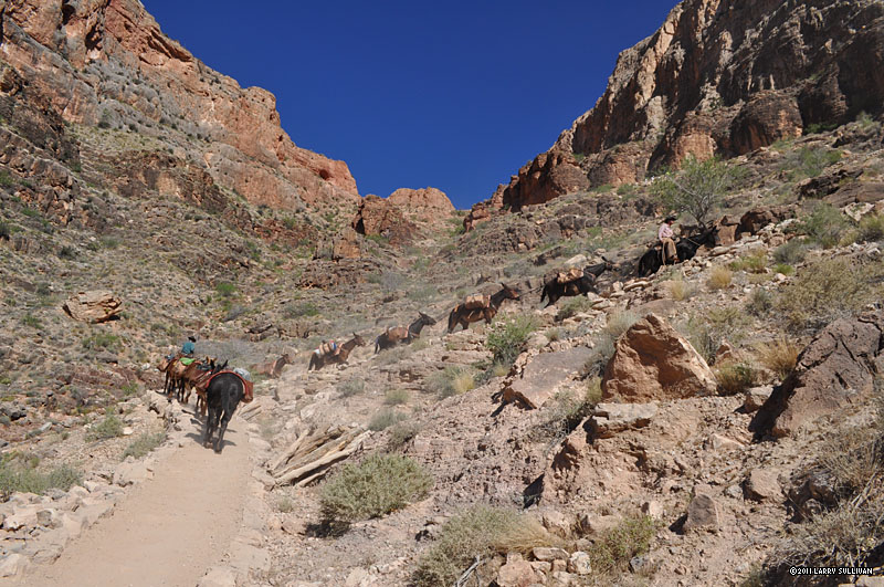 The mules carry all the supplies and food for the park service staff at Phantom Ranch and Bright Angel campground, as well as tourists and their gear. They pack their own feed too, as there's no pasture down there. Coming up must be lighter, but they still haul out trash. |
 Looking south up the mountain from the Tipoff area and a second mule train carrying a group up from Phantom Ranch. |
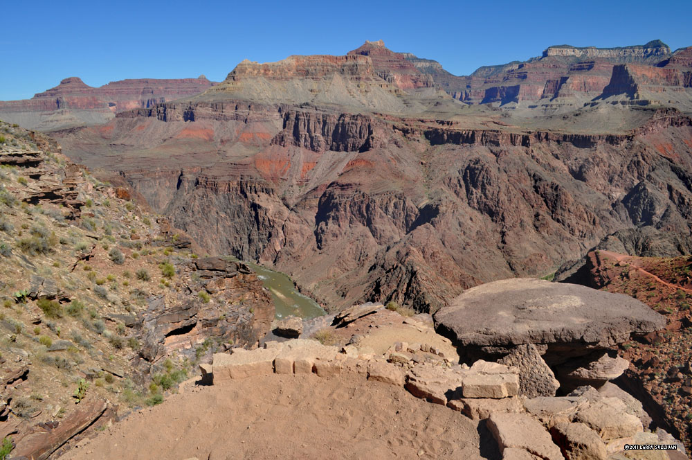 The river, hidden from view much of the hike, is now part of the scenery. Three yellow specks are rafters. |
 The South Kaibab trail and the North Rim of the Grand Canyon across the river. |
 The final leg to the lower canyon is a steep descent with big dropoffs. |
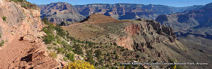
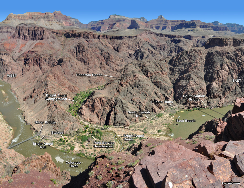
 From a lookout point, a nice view of the bend where green Bright Angel canyon joins the Colorado River. This image with labels is in the Info section. |
 John Wesley Powell's 1869 expedition found clear water entering the muddy Colorado here and later gave it the name Bright Angel creek. Two suspension bridges serve Bright Angel- the South Kaibab bridge at right which serves its namesake trail, and the Silver Bridge in the distance, which carries the Bright Angel trail. The South Kaibab bridge, with it's wooden planks, is the only one built for stock to cross. |
|
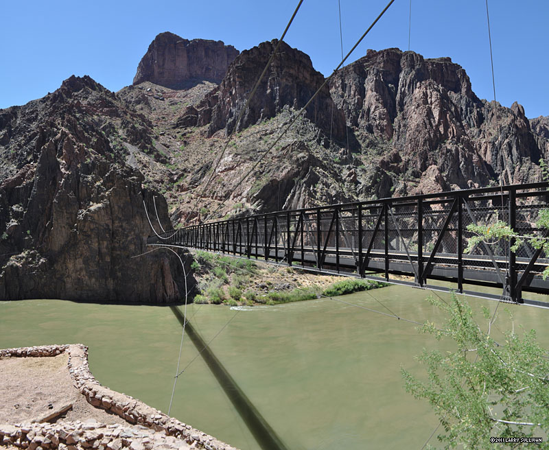 View south up the mountain just descended from the north shore of the South Kaibab bridge. You pass through a tunnel to get on it. |
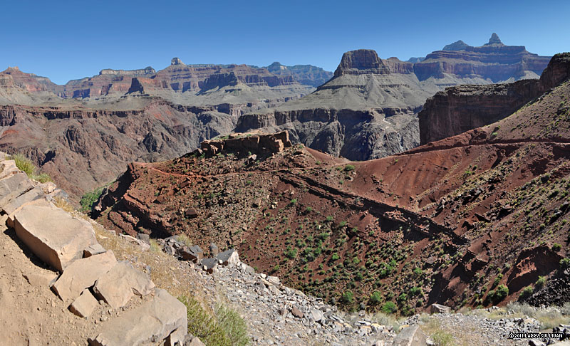
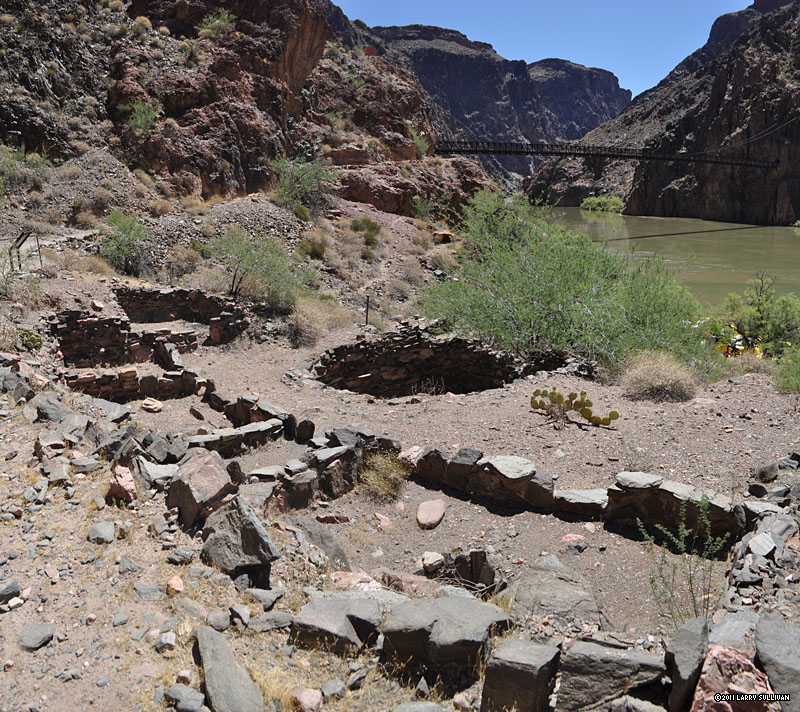 Ancient Indian ruins above Boat Beach still appear much like Powell found them 140 years ago. |
 Bright Angel Creek is a welcome oasis after a long, hot descent from the rim. There are 31 shaded tent sites along the cool creek as well as two large group sites. Phantom Ranch is 1/4 mile upstream. View south toward the river. |
 The Park Service encourages hikers to loll about in the stream, building pools in which to cool off. The stream will revert to it's natural state in the winter. By mid-afternoon, the thermometer shows 107 degrees. |
 Silver Bridge takes the Bright Angel trail across the fast-moving Colorado River. |
 The next morning begins at 3:30am, hiking with headlamp in the dark to beat the coming heat. It's 9.5 mi. to the top. By dawn, I'm halfway to Indian Gardens at this waterfall. |
 Near Indian Gardens, a popular campground destination at the halfway mileage. It's advised to get to this level early in the morning to avoid the scorching heat in the lower canyon. |
 The sun paints the canyon walls above Indian Gardens with brilliant light. By 7:00am, it's already getting hot and the biggest part of the elevation gain is still ahead. |
 The final climb out of the center plateau is 2 miles of endless switchbacks. The trail is soon busy with dozens hiking up from Indian Gardens and hundreds day-tripping down from the South Rim. |
 June morning colors on the Bright Angel trail. |
 A group of a dozen backpackers (bottom center) slowly trudge up the trail beneath the soaring South Rim cliffs. |
 One of two tunnels on the Bright Angel trail. |
 This 1st tunnel means you are very close to the trailhead on top of the Rim. |
 I reach the top just before 11am, almost 7 hours later. A final look north at the route to the river. |
||||
More photos in the Trip Report top of page
TOP![]() Hikes Index
Hikes Index
Since 11.07