Unnamed lake south of Cartridge Pass, Kings Canyon National Park, California

View Lake Basin, Kings Canyon NP in a larger map
Lake Basin, Marion Lake, Kings Canyon National Park, CaliforniaAug. 25-31, 2012
In search of the old John Muir Trail - a demanding trek into a hidden Sierra back range


Overview
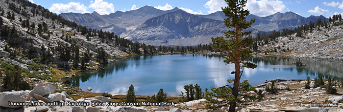
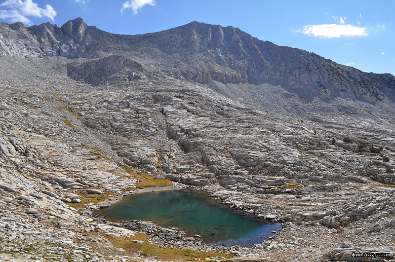
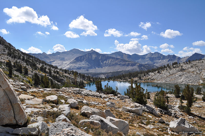
Lake Basin is a high wilderness plateau full of rocky meadows, pristine lakes, ancient trees and rugged mountains on the east side of Kings Canyon National Park in central California, one of many national parks and forests in the Sierra Nevada. Access to this part of the park is difficult because the nearby eastern Sierra is a sheer wall of ridges with some of the highest mountain passes in the country, and there are no roads in much of the western half. The closest pass is Taboose Pass, almost 6000 ft. of elevation gain from the Owens Valley. Then it's another 2500 ft. from the S. Fork Kings River to the top of Cartridge Pass - much of it trail-free - just to gain entry to the basin. This is a strenuous, relationship-ending climb that should be undertaken only by those who are aware and prepared for a hard workout! Of course, the payoff is a spectacular wilderness area well off the beaten path and devoid of people.

A forgotten part of the John Muir Trail
In the late 1800's and early 1900's, forward-thinking mountain enthusiasts were already exploring and mapping routes to create a cross-Sierra path from Yosemite to Mt. Whitney - about 220 miles south. Over the following years, many segments were funded and completed through the hard work and planning of dedicated trailblazers like Theodore Solomons, Joe LeConte and Bolton Brown. As the sections became joined and the new High Sierra Trail - later renamed the John Muir Trail - opened, one of the biggest impediments to a linear route was the seemingly impassible cliffs below Palisades Lakes.This 1200ft. vertical escarpment was so challenging not only because of the looming dropoffs, unstable rock and giant calved boulders, but also because of the remoteness and inaccessibility of the area.

Among the solutions was a difficult bypass through Lake Basin, a rugged
Map, Lk. Basin & the old JMT via Taboose Pass
high plateau surrounded by high peaks and ridges, via the Middle Fork Kings River, Cartridge Creek and Cartridge Pass. This was an imperfect route because the north side of Cartridge Pass is a steep and unstable slope of loose talus which virtually excluded stock travel. However, in the years after the trail opened, daring explorers made breakthroughs climbing over the Palisades, including one Boy Scout leader who lowered mules over the cliffs by ropes. The trail builders then revisited that route, engineers finalized new plans, boulders were dynamited and ramps built, and trail crews constructed a path over the giant wall. The result, completed in 1938, was named the Golden Staircase - the final, and one of the most difficult segments of the John Muir Trail to be completed. The old trail through Lake Basin was bypassed and forgotten.
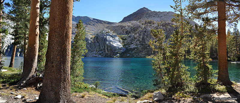
Although it hasn't been maintained in decades and is choked with brush and blocked by fallen trees, this bypassed portion of the old JMT continues to draw curious hikers into Lake Basin. Some parts of the trail are still intact. My trek entered and exited from the south so I don't have any firsthand knowledge of the western connection.

The southern entry from the current JMT is unmarked and hidden behind brush in the center of a hairpin turn a few hundred feet north of the crossing of S.Fork King's Creek, which flows through the deep valley between Mather Pass to the north and the trails to Taboose Pass and Bench Lake to the south. From this entry, there's a clear path for about 1.5 miles west up to the first of the 3 talus landslides until it becomes lost in a tangle of brush and stone. Most maps still show the trail crosses the river to the south bank to avoid these talus slides but the south bank is thoroughly choked with acres of thick brush and downed trees. I entered along the north shore and exited on the south. Despite the overgrowth there are still patches of trail to be found, but there's less difficult terrain on the north side. At the base of the daunting climb from the creek to the first plateau, the trail is almost impossible to spot, but easy to follow once on the steep slope.

Inside Lake Basin, there is a path for much of the route but many times it becomes too difficult to find to be worth the effort when you can simply proceed in the direction you're going. Then, like an old friend, it shows up here and there to guide you.

Marion Lake
This small but beautiful lake is hidden up in a pocket ledge where mostly level Lake Basin drops suddenly west into a deep V-shaped valley. If you didn't know it was up there behind a rock levy, you wouldn't see it from the obvious route through Lake Basin. The most striking feature is the towering palisades wall that forms the southwest bank. Marion Lake is named after Helen Marion LeConte, wife of adventurer and trailblazer Joe LeConte, with whom she helped pioneer much of this area in the early 1900's. A steel plaque honoring her is bolted to a boulder in one of the lakeshore meadows.


Trip Report
This was a season-ending trip to relax at a beautiful lake destination. Although it was a strenuous hike up and in, I didn't do much trail-pounding to other nearby highlights like Dumbbell Lakes and Observation Peak to the north. Those will have to come on another trip. I do have some more photos to add to this section so please check back!
     
Info

Reservations and Permits
Taboose Pass trailhead begins on the eastern flank of the Sierra Nevada north of Independance, California on Hwy. 395 in the Owens Valley. The eastern side is in Inyo National Forest and managed by the US Forest Service; the western side is in Kings Canyon National Park and managed by the National Park Service. A permit for overnight camping is required from the agency which manages your entry trailhead. Permits are now handled exclusively by Recreation.gov and reservations cost $5 per person + a $7 "handling fee". Bring this reservation number to the closest permit station to get your actual permit the day before or the morning of your hike. The closest permit station to Taboose Pass is the Eastern Sierra InterAgency Visitor Center about 35 mi. south, 2 miles south of Lone Pine.

Bear canisters are mandatory in most of Kings Canyon National Park and recommended in Inyo National Forest but not required in Lake Basin.

Camping
The Taboose Creek trail up the eastern side of the Sierra climbs a deep v-shaped valley most of the way up so there are only a handful of established camp sites among the vertical walls. The first is about 1.5 mi. up, a somewhat hidden unlevel site on the north side of the trail (no water). The next is under the giant redwood (cedar?) about 2 mi. up and 1/4 mi. above the stream crossing - a large space for many tents and a small one for a solo. Bring up all water you'll need. Between the 3.5 - 4 mi. mark, there are several more sites. The first is a marginal site along a trickle of a stream and 1/4 - 1/2 mi. further is the best site on the mountain, next to wide year-round stream. There are several more sites in the trees above the talus switchbacks above those. Then it will be a struggle to find a suitable spot as the terrain is all boulders, rugged and exposed to the summit.

Because the trailhead begins at a much lower elevation than most other eastern Sierra passes and requires more effort and time to get over the front range, most hikers will summit the pass on day two, but it can be done in one long day.


Preparedness

Taboose Pass is a long, tough climb up an enormous mountain in hot, dry desert wilderness conditions. If you're not in very good shape, it will not be a fun trek and heat stroke could kill you. Many find the ideal climb to be in the early morning or late evening. Although the trail is well maintained, there are steep exposed dropoffs and millions of sharp rocks where you need to stay alert. To avoid altitude sickness, it's recommended to acclimate the day(s) before by hiking and camping at higher elevations. Drinking a lot of water before your hike is said to help. Even though the water supply in the high Sierra seems straight from the sky, it's recommended that you filter all drinking water. For me, trekking poles are essential to avoid unnecessary strain on the joints, especially on descent.

Directions to Taboose Creek trailhead from the south
Route 395 north of Independance is a 4 lane divided highway through a big open desert with few landmarks. It's easy to miss Aberdeen Station Road as there is no large highway sign marking it, only a small road sign on a post. From Independance, it's 14 miles north. After passing Goodale Creek Campground, look for a left turn lane to Aberdeen Station Rd.
On Aberdeen Station Rd., it's 5.7 mi. from Hwy 395 to the Taboose Pass trailhead. There are currently signs for Taboose Creek trailhead at the intersection. After 1.2 miles the pavement ends and becomes a series of dirt roads meandering generally west/northwest. There are half a dozen forks splitting off but it's not too hard to tell which is the main road to stay on.

At 3.9 miles the main road splits in two. A sign should show the left fork is Road 11S02 which looks like it takes you up the mountain to the correct place. Stay right - the trailhead doesn't begin up the mountain. The last 3 miles is rough dirt and sand with sharp fist-sized, tire-puncturing rocks protruding and it's slow going unless you have big thick 4WD tires. (It's recommended you have a spare tire at the ready) I have a sedan and it took about 20-25 minutes from Hwy. 395. The surrounding scrub and berm hides the true direction and there is little to go on but faith that you're driving out into the desert on the right road. Then, suddenly, around a turn, the road just ends among the rocks, with virtually no turn around. Hopefully there will be cars there to alert you. There's no parking lot, parking is along the shoulder. If the dozen or so spaces are full, there's no place close to park - but you're a hiker. The trailhead is up on the mound east of the road.
Finding the old John Muir Trail from the current JMT
Beginning of trail up is almost invisible
1. Beginning of trail up is almost invisible
Looking south from the beginning of the trail up - the clearing & spherical boulder
2. Looking south from the beginning of the trail up - the clearing & spherical boulder
GPS waypoint - beginning of trail up to Cartridge Pass
3. GPS waypoint - beginning of trail up to Cartridge Pass


Finding a trail west from the JMT isn't too hard. On the way out, I set out west where the JMT crossed S.Fork Kings River and eventually found a faint use path. On the way back, I found the better trail connects with the JMT several hundred yards north of the creek xing - hidden in a hairpin turn.

There's a fairly strong trail along the north side of the river until it disappears a few hundred yards before the first talus field. From there across the 3 talus fields is challenging and slow going. There's lots of brush and downed trees, climbing on the talus is slow & risky (and to be avoided) and it's a lot further than it looks! Crossing the river didn't really help - both sides are equally bad, but there are segments along the south bank with a usable trail.

Here's a GPS waypoint of the beginning of the trail from the flat river plain going up the steep slope.

N36 57.432 W118 28.401

I marked it coming back, following the trail down. The trail up begins by a clearing where there's a somewhat spherical boulder. It would be difficult to find without this waypoint, even looking directly at the trail, you could miss it.

Pictures
Getting there
The Eastern Sierra and Mt. Whitney (background, far right) from the permit station
A welcoming beam of light directly on the trailhead promises an enjoyable trek


On the trail
Starting up Taboose Pass at sunset to beat the heat.
Next morning, the view west on the other side of the pass.To the left is Bench Lake. To the right is the trail to Cartridge Pass.
After crossing the John Muir Trail comes cross-country route-finding through the scrub trying to locate bits of the old JMT along the stream. Arrow Peak above the S. Fork of Kings River.
The beginning of the Cartridge Pass trail up from the river plain is virtually invisible. (Ask me for a GPS waypoint!)
The extremely steep climb to the first plateau is mirrored on the wall opposite. South across the deep valley to the Bench Lake side.
At the top of the plateau is a beautiful unnamed lake. I took some nice shots of this lake on the way down (below)
Across the water, you can see there is still alot of climbing to the top of Cartridge Pass, at right beneath the spire
Near the top of Cartridge Pass, a tarn in the foreground, a bit of the unnamed lake and far across the valley, Bench Lake.
A 180 degree panorama looking into Lake Basin from atop Cartridge Pass, 12,166 ft. Cartridge Peak at left. The Basin landscape looks a little rugged and exposed but it gets much greener and approachable as you venture inside.
Lakes and rivers in the Sierra seem to compete with the sky for dramatic effect
Moving west cross-country through Lake Basin, one comes across numerous lakes and a massive walls of stone
After many hours of cross-country wayfaring through Lake Basin, Marion Lake, hidden on a plateau above Cartridge Creek valley.
The highest point on the ridgeline above the lake is 12,719 ft. Marion Peak
Much of Marion Lake is bordered by grassy shores and old growth conifers
Marion Lake, Kings Canyon National Park, California
Late afternoon on the north shore
A 3/4 moon painted the forest with light in this time exposure
Marion Lake sits high on a plateau. View west down Cartridge Creek valley toward Triple Falls
The drainage from Marion Lake joins with Cartridge Creek and makes its way south to the Monarch Divide region of Kings Canyon
A steel plaque attached to a boulder pays tribute to Marion Lake's namesake - Helen Marion LeConte, who explored here with her husband in the early 1900's.
The tribute boulder overlooks an idyllic lakeside meadow
Marion Lake in Lake Basin, Kings Canyon National Park, California
Meadows and forest border the north and east side
Rugged palisades drop into the west side of the lake
The crystal clear water is full of trout, mostly 10-12in. long.The crystal clear water is full of trout, mostly 10-12in. long.  
When weather blows in, Marion's colors shift dramatically.The final day, I climb to the high ridges to explore the upper basin. At top left is a pass used by hikers descending from Horseshoe Lakes.

View west/northwest across the lake and down Cartridge Creek valley.
Meadows and grasslands cover the plateau atop the south end
This kind of manicured-looking landscape is common throughout the Sierra
View north from the rock ledge above the south end of the lake
Its rarely cloudy for long in the Sierra and by days end the weather front pushed off
Sunset over Cartridge Creek valley
The sun puts on a good show for my final evening
Alpenglow on Marion PeakAlpenglow on Marion Peak Much of the terrain in Lake Basin looks like this, with many high walls and lakes to navigate around
Much of the terrain in Lake Basin looks like this, with many high walls and lakes to navigate around
Clear shallow water of an upper Lake Basin lake
The steep talus slope across the eastern-most Lake Basin lake is the north side of Cartridge Pass
More of a goat trail than a path, this untenable vertical portion of the old JMT was the reason the trail was redirected out of Lake Basin altogether
A look back into Lake Basin from the north side of Cartridge Pass
The tarn on the south slope of Cartridge Pass below 12,691 ft. Mt. Ruskin
The second lake on the south side of the pass is on a high ledge and can't be seen unless you're near the top
The vista south from Cartridge Pass is one of the most sublime in Kings Canyon
This unnamed lake is a sister to Bench Lake across the valley, also on a high plateau.
Distant Bench Lake is about the same elevation, but much larger.
Unnamed lake south of Cartridge Pass, Kings Canyon National Park, CaliforniaUnnamed lake south of Cartridge Pass, Kings Canyon National Park, California Spongy soft shoreline sod irrigated by channels of water
Spongy soft shoreline sod irrigated by channels of water
Arrow Peak from the steep trail down to the river
Old growth conifer know which direction to face for sunlight
Descending the old John Muir Trail from Cartridge Pass. East (left) to west (right) across the S. Fork Kings River valley. Just over the ledge at center is Bench Lake. The new JMT and Taboose Pass are up the valley at left.
Back up to Taboose Pass as a weather front moves in
Last look west from Taboose Pass at Bench Lake getting some showers
It was a little dicey climbing the high pass choked in low clouds but I beat the storm. The eastern side still had sun.
After hours of descent, it's still a long way down to the valley floor.
A mule train carries tourists up Taboose
On the final morning, a mule train carries tourists up Taboose
The snake of greenery distant center shows where Taboose Creek flows to the Owens Valley trailhead
       

More photos in the Trip Report top of page

TOPHikes Index


Since 12.09