3 days south to north across the park on Labor Day weekend.
.
| Yosemite and climbing Halfdome
from Mono Meadows to Tenaya Lake via John Muir trail. 3 days south to north across the park on Labor Day weekend. . |
| Summiting Yosemite National Park's Halfdome is one of the most compelling climbs in the world and requisite for any accomplished hiker. Its distinctive shape is universally recognized as a symbol of nature's most impressive and sublime creations. John Muir referred to it as a "new revelation in mountain forms". The first time you see Halfdome, whether from below in the Yosemite Valley, or across the canyon from Wawona Tunnel or Glacier Point, there is an instant familiarity coupled with awe. The immense scale of it, impressive enough if it stood alone on a plain, is enhanced by the dramatic sheer granite walls and waterfalls of its surroundings and the beauty of the lush, green valley below. The 16-mile hike to the top of Halfdome and back can be done in one long day (be prepared to start pre-dawn or come back in the dark) or in a multi-day backpacking trip, usually involving an overnight stay at Little Yosemite Valley (LYV) backpackers campground. The LYV campground has quota's to reduce crowds so you'll need to plan many months in advance to get a permit to camp there, although some permits are reserved for first-come-first-served walk-in's. If you plan ahead and become knowledgeable about the rules, the risk, the crowds and the effort involved, you can form a strategy for the best Halfdome climb experience. Overnighting on the mountain will get you a crowd-beating early start, or consider setting out around midnight with headlamps to arrive at the cables at dawn for sunrise. Having a Halfdome plan can make the difference between a euphoric conquest and a lamentable ordeal. Mist Trail Most hikers climb Halfdome via the Mist Trail from Yosemite Valley, although I didn't this trip. Regardless, here's some insight to this route. Mist Trail, the most common entry path to Halfdome, is also the beginning of the 211 mile John Muir Trail (JMT) that ends at Mt.Whitney in the eastern Sierra, the highest peak in the contiguous 48 states. The steep climb to thundering Vernal and Nevada Falls is the most popular dayhike in the park. Mist Trail starts at Happy Isles, beyond Curry Village in the east end of Yosemite Valley, as a wide, paved path that climbs a steep canyon beside the rushing Merced River. Dramatic peaks and giant trees tower overhead. At a bridge crossing a half mile up, the John Muir Trail splits from the Mist Trail and climbs to the south side of Nevada Falls high above. Because the grade isn't as steep as the Mist Trail, the JMT is heavily used by horse and mule outfitters and can be disgustingly covered with stinking manure and flies for long stretches. I recommend avoiding it until you're atop Nevada Falls. After the bridge, Mist Trail becomes a series of hundreds of steps chiseled and blasted out of sheer granite walls. As you near dramatic Vernal Falls, wet spray blows down the canyon, offering cooling refreshment in the hot sun, but making the trail wet and slippery. Hiking shoes with lugged soles are recommended. The final hundred yards climb to the cliff from which Vernal Falls leaps into space is along a narrow, single file ledge above a big drop-off. There is a viewing platform on top and the trail continues up along the river to Emerald Pool and the Silver Apron, it's shoreline of polished, white granite. Above the lake, the Merced rushes over sloping granite fields in a frantic whitewater slide for hundreds of yards. Further up, the Mist Trail crosses the river on a bridge and continues to climb the canyon. After many more switchbacks and endless series of steps, you hear the roar, and then behold the awesome power of Nevada Falls bursting over a high, wide cliff above. The water hits the cliff near the bottom of its fall and bursts into huge clouds of spray. On top of the towering cliff, the Mist Trail ends at the John Muir Trail, which continues northeast to Halfdome. There is close access to the Merced River atop Nevada Falls, including a viewing ledge below the precipice and a bridge above the river. After following a welcomingly level segment along the banks of the Merced one half mile to Little Yosemite Valley (LYV), the trail to Halfdome—now the JMT—begins climbing up a mountain again. 2 miles up from LYV is the junction with the Halfdome trail. The Halfdome trail climbs 2 more miles of steep grade through thick woods, with only limited peeks at the surrounding landscape, as you climb all the way around behind Halfdome to the far northeast side. Above LYV, you don't see any more of Halfdome until the trail breaks out of the woods miles above. The final segment of the climb, up the face of adjacent Subdome, aka The Shoulder, is a strenuous ascent of steep switchbacks and then a scramble up a slippery, unmarked granite face above a gaping exposed chasm. Only then do exhausted hikers arrive at the most challenging—and scary—part of the hike: ascending the cables to the summit. The cables The cables are a ladder of thick wire that you use to pull yourself up a 60 degree slope of slippery granite to the top of Halfdome, and lower yourself back down again. The cables are 3/4 in. braided steel handrails supported by vertical steel uprights anchored in holes drilled every 10 ft. in the granite face of Halfdome. The cables are anchored independantly to the mountain from the uprights. Fastened to the base of these posts with steel straps are 2x4 in. wooden cross pieces that serve as steps. Up and down climbers use the cables simultaneously, keeping to their right. The climb of 500 yards takes 15-20 minutes but that can double when the cables are crowded. On busy days, a queue at the base of the cables can result in hour-long waits. Add in another hour on the top waiting to go down and you can see the value of planning your climb ahead to circumvent traffic jams. |
The granite between the uprights is slick from a century of footsteps, so you'll use your arm muscles as much as your legs on this 60 degree slant. If you fear heights, this final segment is not for you; if you lose your grip or your nerve, you are toast. If you grow tired, you can take short breaks on the cross pieces, but when the cables are busy—which is almost always—this will incur the disdain of other climbers, who are forced to clamber dangerously around you. Some hikers wear harnesses and clip on to the cable with carabiners, but this imperfect solution requires unclipping and re-clipping at each new post. More significantly, it adds danger to the climb of other hikers, who are forced to let go of the cable to get around. A better solution is to prepare yourself with a thorough exercise regimen, wear sturdy gloves and turn back from the cables if the weather becomes threatening. Hike informed Halfdome's accessible location in Yosemite Valley puts the hike within reach of ordinary dayhikers. You don't need special equipment or training, but you do need to be in good shape and do your homework, as the strenuous 4800 ft. of elevation gain (and 4800 ft. drop), 12 hour up-and-back hike is not a "walk in the park". Wise hikers train for weeks and months to climb Halfdome. In addition to cardio, a regimen of pullups or pushups is recommended to get your arms in shape for the cables. You should be wearing gloves to protect your hands from the braided steel cables and lugged sole hiking shoes as the well-worn granite is slick. Leave children, the unfit and pets below. Summer temperatures are routinely 90+ degrees in the Sierra and you'll need to drink a lot of water to stay hydrated. Consuming 3 liters per person is the recommended minimum. If you have a filtering system, the last easy water source is the Merced River just before Little Yosemite Valley. There is also a hidden spring a few feet off the trail about 1/2 mi. up the Halfdome trail after it splits from the JMT. It's on the left behind a large tree - look for people taking a break there or listen for it. This is a big wilderness area, and although you'll rarely be out of site of others on this popular trek, you need to be self-sufficient here - rescue may be many, many hours away. If you do have an emergency and are able to get reception on your cell, they'll likely send up a team from the Valley on foot to carry you out and it will take them as long to get there and back as it took you. There is no official Park Service presence on Halfdome or at the base of the cables, no rangers to organize or regulate traffic. Every year, Yosemite Mountain Rescue brings dozens of visitors off the mountains - usually from dehydration/heat exhaustion and sprains. Every season, another seemingly preventable accident makes the news. Numerous fatalities have occurred on Halfdome, usually during bad weather. The already slick granite at the cables becomes treacherous when wet. A hiker died on Halfdome during my visit in June 2009, witnessed by camp mates. Here's the story. One lesson from this story is that the upright posts can come out of their holes - they're not bolted in. Check the security of the upright posts' seating in the granite before you rest your full weight on it. Although the cable itself is secure, a momentary loss of balance from an unseated upright pole could be disastrous. Whether this is the reason for the this climber's death isn't clear. As with any peak, and especially true for domes, never climb in storms as lightning routinely strikes these high, exposed peaks, even when the storm is miles away. If dark clouds are in the area, they can blow over Halfdome astonishingly fast. Despite a lightning warning placard at the base of the cables, numerous people have been struck by lightning atop Halfdome. There is a heated debate in the hiking and climbing community and much concern in the National Park Service about safety at Halfdome and other risky climbs like Angel's Landing in Zion National Park. Some feel the Park Service should be held liable for any accident because a safe ascension of the cables can't be guaranteed, or that they should be removed so only trained climbers with proper gear can summit. On the far end of the debate, some feel it necessary for a tragic accident now and then to keep clueless tourons away. One thing is certain - a wilderness made 100% safe for everyone would be enjoyable to no one. So hike informed and have an enjoyable Halfdome experience. |
| Labor Day weekend and perfect weather for a 3 day outing. I'd hoped to do a north-south trip, parking on Tioga Rd, climbing Halfdome on the way down to the Valley floor, and return by shuttle. But I hadn't planned this trip months in advance and all the trailheads had full quotas, so I couldn't get a Wilderness Permit. Nor could I get a camping spot in the fully packed Valley, so that I could line up early at the Ranger Station and hope for one of the coveted walk-in permits in order to do the trip in the opposite direction. I would have to reach Halfdome from a more distant trailhead. After some research, some quality time on the Yosemite reservations site, and finally a phone conversation with a very helpful park ranger, I scored a slot at the Mono Meadows trailhead on Glacier Point road. The stipulation was that I wasn't allowed to spend the first nigh t at the backpackers campground in Little Yosemite Valley above Nevada Falls, in order to reduce the crowd there. This turned out to be a much better solution, as I avoided the traffic and crowds in Yosemite Valley, on Mist Trail and in Little Yosemite Valley, saw almost nobody at all on the wilderness trails on a Labor Day weekend and got to explore much more of the park. I left LA Thursday night after work and drove up to Oakhurst, the closest town outside Yosemites south entrance. I arrived around 10:00pm and got a room I'd reserved and had a few minutes to hit the jacuzzi. Day 1 An early morning start put me at the Wawona Ranger Station to pick up my permit when they opened at 8am. I drove out toward the end of Glacier Point to the Mono Meadows trailhead and was on the trail by 8:30. The trail quickly descends out of thick woods across miles of rolling meadows, under the rounded peak of Mt. Starr King. As the sun rose, so did the heat. I arrived hot and sweaty atop Nevada Falls 4 hours later, stripped down and plunged in to the wide pool above the bridge. The water was COLD and although there was a good-sized group splashing about on top of Nevada by lunch time, no one had dared to dunk any more than their feet. Some were concerned that swimming in this pool above the falls was risky (they told me), but the water was relatively low and slow and I'd swam here before when it was deeper and faster. After I plunged in and swam around, one by one, other brave souls inched their way in too. When I left, the icy water was full of people. I hiked several miles above Nevada Falls on the John Muir trail, past the Little Yosemite Valley hikers campground, all the way up the mountain to the Halfdome spur trail junction to camp for the night. I found a secluded flat spot up the JMT a few hundred yards north of the Halfdome trailhead to set up for the night. It was a great boost to be up so high when I set out in the morning, as it's a formidable climb just from Little Yosemite Valley to the Halfdome trailhead, and very strenuous to the top of Halfdome from there. Throughout the night, I could hear groups of hikers climbing up in the dark. Their trek poles klak-klakking on the stones and voices ringing out over the mountain kept me awake. Some I spoke with later began from the Valley floor as early as 1am. |
Day 2 The next morning, I left everything but some water and snacks behind at the tent and began the grueling climb to the summit of The Shoulder, the big mountain adjoining Halfdome to the north, from where you access the cables. Like most, I was unaware of how difficult and steep this 2 mi. segment would be. It's tough! It gets steeper the higher you climb and towards the top, there are narrow switchbacks, slippery granite faces and steep dropoffs that
The meticulous 15-20 minute climb up the cables is thrilling and takes as much arm as leg strength. If you are unable to do a single pullup, you will have a scary time on the cables. Finally, exhausted, standing on the summit of Halfdome is transcendant, euphoric, sublime; the view epic. After the triumph of Halfdome, it was time to begin the long climb up the John Muir and Forsythe trails toward my second camp, Sunset Lake. I'd planned to hike Clouds Rest on the way, but the 1300 ft of vertical to the top of Forsythe trail was killer enough after Halfdome and I didn't have it in me to summit an even higher peak. Even though the climb to 9000 ft was a struggle, I had this magnificent wilderness all to myself for the rest of the afternoon. I dragged into the first, western-most Sunset Lake as the light faded, set up camp, ate, and collapsed. Day 3 The next morning was glorious. After a long switchbacked descent from the Lakes, I arrived at Sunrise trailhead on Tioga Rd. around 11am. There was only one hiker shuttle back to the valley that day and it was hours away, so I stuck out my thumb and caught a ride in minutes with another backpacker from the Bay Area who took me the 25 miles down to Crane Flats. A second ride got me to the Transit Center in the Valley, where I discovered there was only one bus to Glacier Point and it had been booked long in advance. The park could definitely use additional shuttle service, especially on holiday weekends. So I hitched a third ride with a Yosemite paramedic who just got off work and was nice enough to take me from the Transit Center in the Valley up Hwy. 41 and all the way out Glacier Point road to my car, even though he lived the opposite direction. I gave him some cash, and cold cokes from the cooler awaiting in my trunk. It was easy to hitchhike on this beautiful morning, as everyone was in a vacation-like mood. Carrying cash for just such an eventuality helped too. By 2:00, I was on my way back to LA, exhausted and exhilirated and already planning my next Yosemite hike. |
| It costs $20 to enter the park, good for 5 days. Parking is free throughout the park. All over night hikers in Yosemite are required to have a Wilderness Permit available to show a ranger. There are quotas for every trailhead and spaces fill up early for weekends and holidays, in some cases, half a year or more in advance You're requested to camp in previously used sites instead of making new ones, but permitted hikers are allowed to camp almost anywhere in the park they want. |
||
| Yosemite trails are
legendary for excellent maintenance and signposts but a good map and
a compass is essential as this is a vast wilderness. Mono Meadows to Sunset trailhead is great way to reach Halfdome. It starts out several thousand feet higher than the Mist Trail and although it has quite a bit of elevation gain, it's nothing compared to the strenuous climb from Happy Isles to Nevada Falls on the Mist. Most backpackers bound for Halfdome on the Mist Trail stay over night at Little Yosemite Valley, 2 mi. above Nevada Falls. It's a large yet primitive tent campground and a good halfway point for resting. Bears wander through LYV regularly and rangers police your food storage strictly so be forewarned. You may see one carrying a shotgun with beanbag pellets on patrol at night. From LYV, it's still a long hike up the mountain on the John Muir trail before you even reach the Halfdome trailhead and begin the strenuous climb up The Shoulder. Plan on departing early if you want to summit Halfdome and get back to the valley floor by dusk. After you hike up the John Muir beyond Little Yosemite Valley and away from the Merced River, there's still one more place to get water. Most people don't know about it. It's a spring, hidden behind a tree about one half mi. up the Halfdome trail from the trailhead off the John Muir trail. You can hear it gurgling as you pass but you'll have to look over your left shoulder to see it on the way up. (If no one is there). This spring can be helpful if you have a filtering system and drank more water than you planned. |
There is no ranger presence on Halfdome. No one polices the cables, which get completely full of people going up and coming down during the busiest times like holiday weekends. Start early to avoid queues of an hour or more. Halfdome, like other dome mountains, is a giant lightning rod. Never climb it when a storm is approaching. Many people have been struck by lightning on top, even when they were under boulders. Some simply underestimated how fast the storm could get there. The Halfdome cables are taken down every winter. Which is to say the upright poles that hold the steel cable handrails are laid down flat on the rock. It's still possible to climb them for the brave (or foolhardy). There is a once a day shuttle bus beween Tioga trailheads and Yosemite Valley. I'm told it costs $25 cash. Bringing plenty of cash will help you convince drivers to give you a ride should you miss the bus. Bear canisters are required for all overnight backpacking and can be rented for $5/day from ranger stations. |
 Started at Mono Meadows trailhead on Glacier Point Rd. |
 For four hours, I saw no people. Mt. Starr King |
 Back side of half dome |
 Connected with John Muir trail after lunch and first sight of other hikers. This is Liberty Cap, which blocks the sight of Halfdome from Nevada Falls. |
 Down the valley from atop Nevada Falls, which was flowing only half the volume since my last trip. The mountain in the distance is Glacier Point. |
 Mist Trail from Nevada Falls. Had a great swim atop the falls, then hiked up to Half Dome trailhead. Tired hikers make the final push to the top of Nevada Falls. |
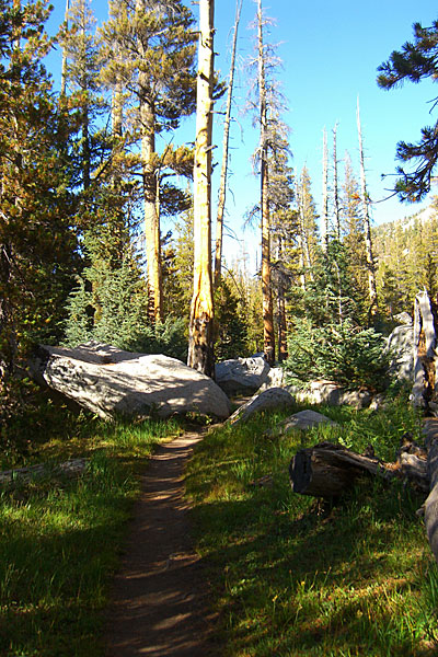
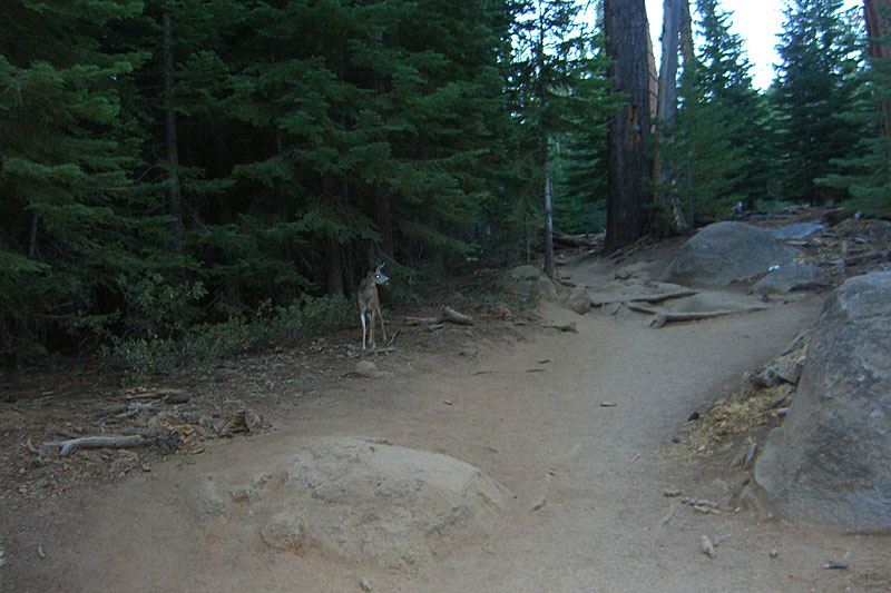 One of many fearless deer. Camped in the woods off Half Dome trailhead and began the 2.4 mile hike up before dawn to beat the heat and the crowds. Heard several groups going up in the dark. |
 The big mountain in front of Half Dome, called the "shoulder", takes a lot out of you, but offers great vistas like this |
 After an exhausting hike, Half Dome comes in to view. First look at the cables, with 2 guys at the very top. |
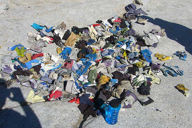 Pile of discarded gloves bottom of the cables is a little disconcerting. It's litter basically. I brought a pair of leather rock climbing gloves just for Halfdome. Cheap work gloves will do fine. |
 Lightning likes Half Dome. The book Shattered Air tells the story of lightning disaster atop Half Dome in 1983 when 3 hikers died. |
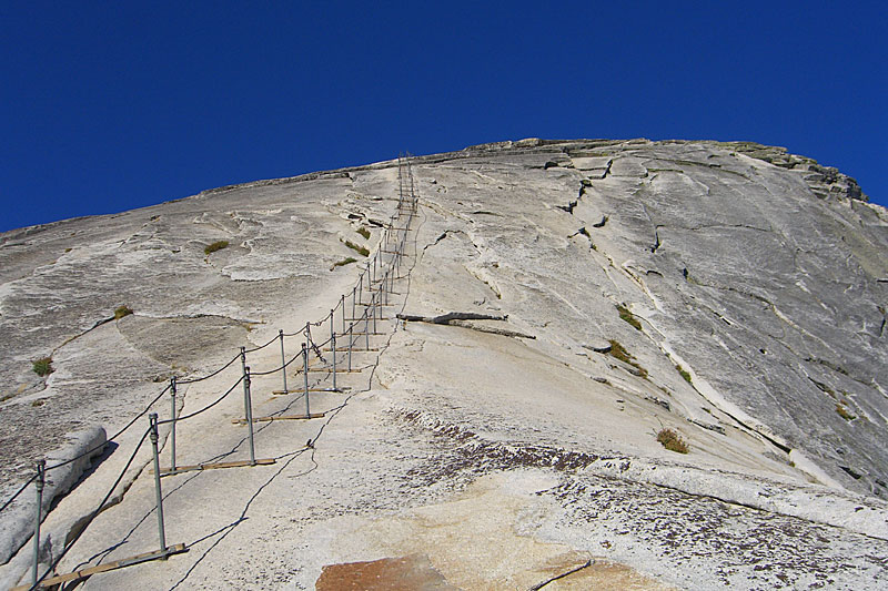 A rare sight - empty Half Dome cables on a weekend. The advantage of camping high and starting early. |
 It takes more strength than I thought to pull yourself up these cables. The marble is slippery so its not just clamboring. |
 I asked another hiker to get this shot of me, my favorite of the trip. Here's the big version. |
|
 Northeast up Yosemite Valley, carved by glaciers. |
 |
 Promised myself last visit that on my next trip out, I'd be standing on Half Dome, looking back to Glacier Point, the drive-up overlook park on a sheer cliff (the shadow behind me) high above the valley. |
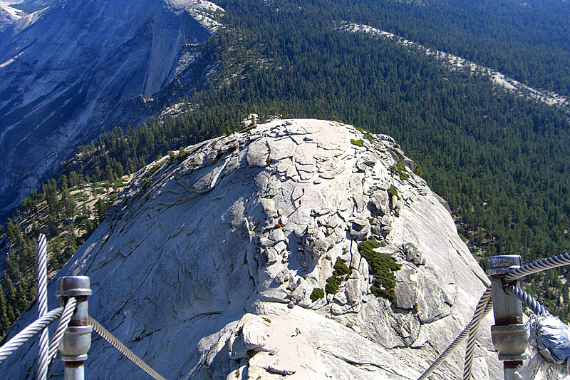
 The summit is large and relatively flat, with some unique rock formations. |
 Cairn city |
|
 More people were coming up the cables now, everyone exhausted, thrilled and slightly terrified. |
 You can see the small talus cave at the precipice where the unfortunate hikers killed by lightning in 1983 took refuge, but to no avail. |
 Ready to descend, a step in to thin air. Hadn't seen anybody go down so I'd have to invent my technique - facing forward or backtracking? |
 Facing forward was easiest. I stopped to let a large group climb up by— an interesting logistical challenge seeing as how you don't want to let go of the cables—and let Jeff, a fellow hiker from Alabama, pass by me. |
 Back on solid ground in one piece. One tired guy waiting to ascend the cables remarked, "Hey look, they sent two guys down to carry us up!" |
|
 As the sun came up, the day turned glorious. Yosemite Valley looking northeast from Half Dome shoulder. |
 More people were arriving. Jeff and I were both heading north so we hiked down together. |
 As the morning warmed, a steady stream of exhausted groups were arriving at the summit of the shoulder. Some said they were envious that we were going down. It felt good to be the only ones going down and remembering how hard a climb up it was! |
 A last look back at Half Dome as we started up the John Muir Trail. You can see what a formidable climb it is just to summit the Shoulder and access the cables. |
 North up the Forsythe Trail into the wilderness. The trails are well maintained. Wherever these giant trees have fallen across trails, they've been sawed to make a clean passage. |
|
 A nice meadow where Clouds Rest and Forsythe trail meet. Steel signs mark the way. I started at Half Dome trailhead and had 3 miles to go to reach camp tonight. |
 |
 Sunset and my tent on the first (western-most) Sunrise Lake. I usually stay 100 feet off the water but this was on solid rock. |
 Sunrise on Sunrise Lake and no critters had gotten in to my bear-cannister. |
 A pond near Sunrise Lake. |
|
 After I caught several rides and got back to my car at Mono Meadows, I took a spin out to Glacier Point for a last glimpse of Half Dome. |
||


