Wraparound views of LA and the famous landmark up close
| Top of Griffith Park and the Hollywood
sign Santa Monica mountains, Los Angeles Wraparound views of LA and the famous landmark up close |
| Griffith Park is 6.5
square miles of natural and landscaped parkland in the heart of Los
Angeles, bordered by the 101, 134 and I-5 freeways and the Los Feliz
neighborhood to the south. It's the largest municipal park with urban
wilderness area in the US - five times the size of NYC's Central Park.
Most notably the home of the Griffith Observatory, the Greek Amphitheater,
the Los Angeles Zoo, and the Hollywood sign, Griffith Park offers numerous
recreation and entertainment activities for locals and visitors alike,
including museums, golf courses, soccer fields, tennis courts, a swimming
pool, picnic areas, playgrounds, an equestrian center and more. There
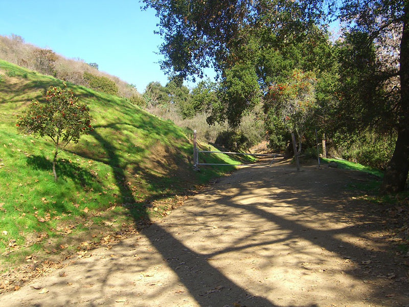
is a myriad of interconnecting dirt roads and paths you'll share with
joggers, hikers, cyclists and horse riders, offering ample opportunity
to escape from the hectic pace of the city into forested seclusion.
Other than by air, there's no better place to get a feel for the layout of the Los Angeles metro area than from the top ridges of Griffith Park. The park is draped over a standalone section of the Santa Monica mountains, which split it in half east to west. The high ridges offer 360 degree panoramic views from the Pacific Ocean and Channel Islands to the San Gabriel front range and all the way south to Mt. Baldy and San Gorgonio mountain. The highest peak is Mt. Hollywood, a short walk up from Griffith Observatory, but Cahuenga Peak, at the west end, is almost as tall. On May 8-9, 2007, a devastating fire burned almost one third of the park, starting in the southeast and spreading around to the northwest. Two years later, most of the landscape is green again but there are still large blackened areas. Griffith Park is named for land owner Col. Griffith J. Griffith,  who made a fortune in gold mine speculation in the late 1800's and gave
the land to the City of Los Angeles as a gift. This free, public park,
although bordered by some of the most exclusive real estate in the world,
has a surprising amount of natural, undeveloped hills, canyons and trails
to hike, ride and explore. On the perimeter is the Ford Theater, an
equestrian center, the famous Forest Lawn cemetery, resting place of
the stars, and the little known
Lake Hollywood, a reservoir built by City Engineer William Mulholland
in 1924 by constructing a dam. A little known side note: In 1928,
a similar Mulholland dam, the nearby St.
Francis Dam, broke and flooded the Santa Clarita valley all the
way to the ocean, killing at least 450 people. It was the worst American
civil engineering disaster in the Twentieth Century and ended Mulhollands
career. The Lk. Hollywood dam has since been shored up.In addition
to the main entrance on Fern Dell Drive in Los Feliz, there are numerous
entrances and free parking areas around the park, but many—like the
one used in this hike—are hidden in winding back streets of residential
neighborhoods.
who made a fortune in gold mine speculation in the late 1800's and gave
the land to the City of Los Angeles as a gift. This free, public park,
although bordered by some of the most exclusive real estate in the world,
has a surprising amount of natural, undeveloped hills, canyons and trails
to hike, ride and explore. On the perimeter is the Ford Theater, an
equestrian center, the famous Forest Lawn cemetery, resting place of
the stars, and the little known
Lake Hollywood, a reservoir built by City Engineer William Mulholland
in 1924 by constructing a dam. A little known side note: In 1928,
a similar Mulholland dam, the nearby St.
Francis Dam, broke and flooded the Santa Clarita valley all the
way to the ocean, killing at least 450 people. It was the worst American
civil engineering disaster in the Twentieth Century and ended Mulhollands
career. The Lk. Hollywood dam has since been shored up.In addition
to the main entrance on Fern Dell Drive in Los Feliz, there are numerous
entrances and free parking areas around the park, but many—like the
one used in this hike—are hidden in winding back streets of residential
neighborhoods. |
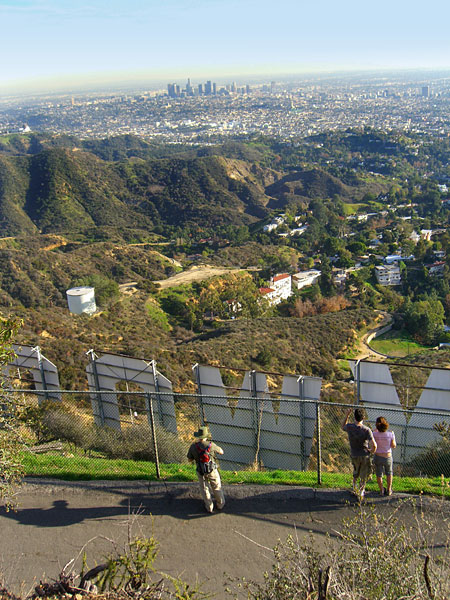
Bronson Caves The entrance closest to the Hollywood sign is Canyon Dr., off Los Feliz Blvd. Near this entrance is the Bronson Cave, aka Batcave, the location of many Hollywood productions. It's most famous from the Sixties Batman TV show, as the cave from which the Batmobile exits. More of a tunnel than a cave, it's worth a side trip to explore. Hollywood sign The Hollywood sign is on the south side of Mt. Lee, which has a large communications antenna and station. A service road to the antenna station provides public access to the sign. The sign is off limits for climbing because of graffiti, vandalism and to  shield
the city from liability from accidents. More than one person has committed
suicide there, including a down-on-her-luck, 24 year old actress named
Peg Entwistle, dubbed "the
Hollywood sign girl", who jumped off the "H" to her death in
1932. The closest you are allowed to it is from the fenced road above
which ends at the communications towers atop Mt. Lee. Posted signs declare
a $283 fine for trespassing. There are security cameras, infrared monitors
and loudspeakers from which warnings are issued. Helicopters buzz by
at low altitude. shield
the city from liability from accidents. More than one person has committed
suicide there, including a down-on-her-luck, 24 year old actress named
Peg Entwistle, dubbed "the
Hollywood sign girl", who jumped off the "H" to her death in
1932. The closest you are allowed to it is from the fenced road above
which ends at the communications towers atop Mt. Lee. Posted signs declare
a $283 fine for trespassing. There are security cameras, infrared monitors
and loudspeakers from which warnings are issued. Helicopters buzz by
at low altitude. While I was there, a defiant group scrambled up the steep embankment from the neighborhood below and posed for pictures in the letters. Suddenly, the loudspeaker crackled with a stern warning - "We have you on video camera. Remove yourself immediately or you will be subject to citation or arrest." Someone started yelling out from the communications station at the top of the ridge, "Get the hell out of there!" It was a cop and station worker, but it was obvious they weren't going to scramble down the steep, brambled terrain to try to pursue the trespassers. The group started back down the hill but I don't think they got arrested. Apparently, only those who refuse to leave will be cited. My hike I prefer to hike remote mountains to get away from urban sprawl, but climbing to the top of any interesting place for the first time is always a satisfying discovery experience for me and that was the case here. The sheer size of the Los Angeles metro area, with its skyscrapers, freeways, bridges and endless humanity, nestled between 8000 ft. peaks and the Pacific Ocean, is awe inspiring. Although I've lived in LA 9 years, this was my first extensive hike in the park, to the high ridges and the Hollywood sign. It was a clear day after some rains and strong Santa Ana winds had blown away most of the haze and smog. I walked and climbed 8-9 miles of trails and spent 5 hours discovering the park and its excellent wraparound views of the Los Angeles metro area, returning to my car at dusk. |
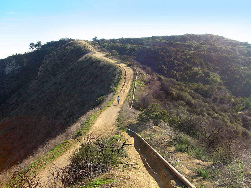
| Getting a close up view
of the Hollywood sign is only possible if you hike, bike or horse it
up the mountain. The road to the antenna station above it is off limits
to unauthorized vehicles. It takes about an hour to climb up to the road above the sign from the closest park entrance. It's a good workout, as it's uphill most of the way. There are several shortcut trails should you be proficient with direction-finding. |
There's no water on the mountain trails and temperatures are often high. |
| From Hwy. 101 in Hollywood,
exit N.Highland. Go south, T/L Franklin. T/L Canyon Drive and follow
it to the end. There are many parking areas and street parking also. Griffith Park is open to the public from 5:00 a.m. to 10:30 p.m. Bridle trails, hiking paths, and mountain roads are closed at sunset. |
|
|
| ||
 The Canyon Drive entrance to Griffith Pk. is closest to the Hollywood Sign |
 The sign is below the antenna atop Mt. Lee |
 On clear days, the ocean is right there. |
 Looking southwest to the canyon just ascended. At far right,the tall buildings are in Westwood |
||
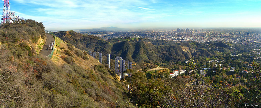
 From the path to Mt. Hollywood, a 180 panorama looking east to the eastern San Fernando Valley (left), Burbank below the Verdugo Mtns.(center) and (right), the tall buildings of downtown Glendale. In the background, the San Gabriel front range. Following the ridgeline south/right, you can see the snow-capped peaks of 10,000' Mt. Baldy and 11,500' San Gorgonio mountain in San Bernardino county at far right. Here's the big version. |
|||||
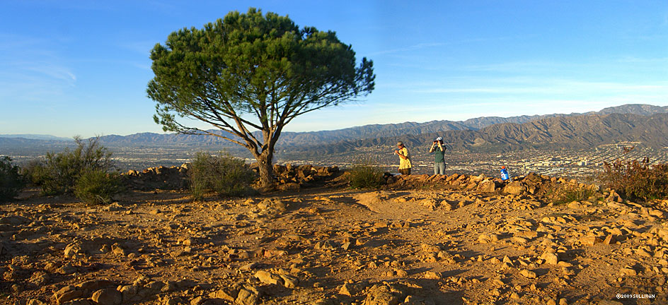
 Approaching the Mt. Hollywood (right) vista point from the back side |
 View east from the path near Mt. Hollywood, of Glendale and the San Gabriel mountains. This view shows the beginning stages of recovery from the devastating 2007 fire. |
 Mt. Lee and the Hollywood sign from Mt. Hollywood. Behind the antenna is Cahuenga Peak. |
 Southeast toward the Inland Empire, Mt. Baldy and San Gorgonio mountain. This part of the park was heavily damaged in the fire. |
 Just in front of downtown is Griffith Observatory. |
|
 The closest you can legally get to the sign is by walking up the gated service road above it, or risk a $283 fine. The group posing in the "L" scrambled up the steep bank from below. In the next few seconds, they got threatened by loudspeaker and yelled at by a cop for trespassing. |
 |
 Mt. Lee and the Hollywood sign from the trail to Cahuenga Peak |
|||
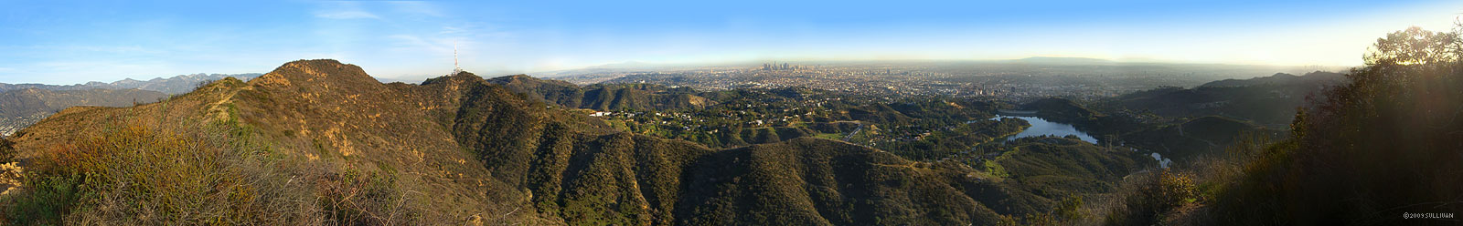 This 180 degree east-west view from Cahuenga Peak shows (l-r) Mt. Lee, Mt. Hollywood, downtown LA, Lk.Hollywood reservoir, and in the far distance above it, the mountain is Palos Verdes peninsula. At far right, the skyscrapers of Westwood are visable, and the ocean and the Channel Islands could be seen at right. Here's the big version. |
|||||
 The Las Vegas desert high country? No, Cahuenga Peak in Griffith Park, in the very middle of Los Angeles. View northeast. |
 From the highest point of Cahuenga Peak looking southeast. You can see the steep path up following the ridgeline. |
 Southeast from Cahuenga Peak with the Sign, Griffith Observatory and downtown LA |
 You'll share most of the dirt roads and bigger trails with horses. |
||
Since
4.09
|
|||||
