 |
|
| Buckskin Gulch & Paria Canyon, Paria Canyon-Vermilion Cliffs Wilderness, Utah & Arizona A 21 mile adventure through deep slot canyons and alien landscapes |
Picture traveling an entire day through the hot desert wilderness, but hundreds of feet below the surface in a cool subterranean passage. The light filtering in from high above highlights the sandy path and paints the wavy walls yellow, orange, red and blue. The echo of your voice rings down the corridor - there's no one else around for miles! Deep in the expansive wilderness of southern Utah and northern Arizona, Buckskin Gulch and Paria Canyon is the longest continuous slot canyon in the world. This area is in good company for dramatic geologic exhibitionism, situated as it is 100 miles north of the Grand Canyon. The fact that most have never heard of it is not a bad thing to those who've been there. Once you hike it, you almost don't want to reveal the magic to others. But this place is big enough that you can feel like you don't have to share it. |
Wire Pass Wire Pass is the name given to a shortcut canyon to Buckskin Gulch. It's a brief but interesting non-technical slot canyon of its own, a sandy path between high warped walls in flickering sunlight. Wire Pass trail starts in a wash at House Rock Valley road, and ends 3 miles later when it joins Buckskin Gulch. It's dry most of the year and is popular as a family dayhike, but there are some flood debris obstacles to scramble over and under. Wire Pass is noteworthy as the trailhead to reach the Wave. A permit is required at all times here. The Wave
Paria Ranger station There's a lot of big open space, and not much civilization out in this part of southern Utah, so the Paria Ranger Station on Hwy. 89 is one of the few stopping points. The Park Service calls this the Paria Contact Station, as it functions as a visitor center where you can buy maps and posters, as well as issue permits for hiking in Wire Pass and Buckskin Gulch. They also have tapped a spring, and have lots of fresh drinking water. |
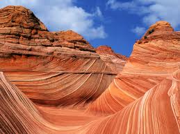
After a week of canyoneering in Zion National Park, I drive east into the vast desert above the Grand Canyon to explore Buckskin Gulch and Paria Canyon. I learned of this area after seeing images of the Wave, the curvy rocks so popular with photographers. I got my permit for a June overnight hike in Paria Canyon back in March, but I'd hoped to score a walk-in permit to The Wave at the daily lottery too. This hike requires a shuttle between trailheads. The end is 15 road miles from the beginning. There are several local residents who will shuttle hikers for $75pp and up (2011). I saw 6 backpackers climb into a shuttlers van at Whitehouse Campground - 6 times $75 is a pretty good profit for driving 30 miles. But then again, I don't think I'd want to live way out here either. But I don't like to pay for rides as a matter of principle, so I'd left an extra day in my schedule to work out the logistics of leaving my car at the exit trailhead and finding my way to the entry. In my experience, when you're doing a car shuttle hike, it's better to leave the car at the end of the hike, rather than the beginning. Not only is there the psychological bonus of finishing your hike at your "home" on wheels, (and a cooler of drinks), but you have a better chance to catch a ride with ordinary folk at the beginning of your hike when you're less trailish looking. After enduring the excited crowds at The Wave lottery at the Paria Ranger Station in the morning without scoring a Wave permit, I drive up to House Rock Valley Rd., the long dirt road out to the Wire Pass trailhead. I want to scope out the trek I'm about to make and the trailhead camping situation. Also, I don't want to haul a bunch of water if I don't have to. There's a tapped spring at the Ranger Station and lots of fresh cold water. There's none at the trailhead. House Rock Valley Rd. is dirt and rock, regularly graded and seems well-maintained, although I've heard that rains make it muddy and impassible. A ranger told me on the phone that many people get flat tires and to check your spare, but I found only a few rough spots on this beautiful dry morning. The countryside is very scenic - an undeveloped landscape of rolling hills with red rock outcroppings, and a few pastures. |
About 5 mi. from Hwy. 89 south on House Rock Valley Rd. is the first trailhead, Buckskin Gulch, the actual beginning of the canyon. Several miles later - about 8 miles from the highway - is the Wire Pass trailhead, a shortcut to the Gulch, where theres a large dirt/gravel lot and 2 new toilets. It's very hot! I set up my tent and stash my overnight gear and lots of extra water. I then retrace my route, driving 15 miles back up House Rock Valley Rd., back east on Hwy. 89, past the Ranger Station to the Paria River trail's exit at White House campground, where I leave my car. Now I'll hike the 15 miles back to the start, as it were. Hopefully, I'll find a ride though... After a 2 mile walk from White House campground past the Ranger Station to the main highway, I was lucky enough to cross paths with a photographer and his wife returning to their car at the Ranger Station from a photo trip to the hoodoo's nearby. They offered me a ride to House Rock Valley Road, going the wrong direction out of their way, eliminating the one bad leg of the hike I wasn't looking forward to - walking for 5 miles on the shoulder of the busy 2 lane blacktop. After profuse thank-you's (no they wouldn't take $20 to drive me 8 mi. more to the trailhead, but I had to ask...) I start walking down House Rock Valley Road in the hot mid-day sun. All my gear for the overnight hike waits for me 8 miles ahead in my tent, so I'm hauling an easy load of much more water than I need and snacks. At first, I plan on sticking out my thumb while walking, but this is a dirt wilderness road in the desert mountains and not one car passes in my direction for the next 4 hours. Nevertheless, after 2 miles in, I decide not to hitchhike regardless, and will make it to the trailhead on my own - this is a hike I'm going on anyway right? The scenery is nice, I have plenty of water and time, take an enjoyable break under an old shade tree. It turns out to be a fine hike, good preparation for the following 2 days in Buckskin Gulch and Paria Canyon. |
| Day 1: Wire Pass to Buckskin Gulch | |||
|

| Day 2: The Confluence, Pariah River, White House campground | |||
|

Hiking from Wire Pass through Buckskin Gulch and Paria Canyon to White house campground
The Gulch is mostly an easy-to-walk sandy path, with no drop-offs and technical climbing. Most of it is in the shade and there is no noticeable elevation gain or loss, but there are a few landslide boulders and obstacles to climb over, under and around. The beginning of the hike is 15 miles from the end by car and road, and 21 miles by canyon hiking. Typically, the 13 miles from Wire Pass to the Paria confluence is day one. 2 days camping is allowed, but there's little water, so day two usually means either turning up north and out the Paria in 8 miles at White House campground, or east down the Paria for 26 miles to Lee's Ferry. (Or backtracking the way you came in). Logistics Those doing this hike with only one car can expect to pay $75 per person (2010) for a local resident with a truck to shuttle them the 15 miles from White House Campground, the trails exit where they leave their car, to the Wire Pass trailhead. The shuttle drivers require 24 hour notice. You can get the current contact info from the Ranger Station listed below. Or, if you have time, like I did, you can hike it. There are two trails from which to enter Buckskin Gulch - the beginning at mile 5 of House Rock Rd., or from Wire Pass trailhead, at mile 8. Wire Pass is also the trailhead to visit the highly regulated Wave, through a nondescript opening on the right about 1 mile in. Wire Pass trailhead is 8 miles south of Highway 89 down House Rock Valley Road, a wide dirt road through the desert wilderness. This road is said to be impassable when wet and a 4WD vehicle is suggested by the park service, who also recommended having a good spare tire available. I got good beta from a recent visitor, and found it well-graded, wide and no problem for my 2WD sedan on this dry, mid-June trip. Overnight camping is allowed at the large parking lot, with more space above it, and there are 2 toilets. It gets very windy here and the dust gets flying. The trailhead is across the road from the parking lot. |
Camping The Park Service has clean, free camping at the White House campground, which has 15 tent spots with benches and grills, some with shade, and 2 new toilets. The campground is 2 miles down a gravel road from the entrance, which is just before the Ranger Station. You might want to stake your tent fully here, as strong gusts thrash through the prairie each morning. The Paria River trail starts behind the toilets at the White House Campground. No permit is necessary to dayhike here. The trail is the river bed, so shoes that don't fill up with water are helpful. Whitehouse rock is within 1 mile, the hobbit houses, 3 miles, and the confluence with Buckskin Gulch, 8 miles. Additional free camping is available at Stateline Campground, 2 miles south of Wire Pass on House Rock Valley road. There are a few places to set up a tent at the Wire Pass trailhead, but it's mostly just a large, gravel parking lot on the House Rock Valley road, by a wash with no shade. There are new toilets. Some people overnight in their cars or RV's. There is a private campground west of the Ranger Station on Highway 89 with showers and RV hookups. Safety Hikers should plan on packing in all their water. At least one gallon per day is recommended. There is no water available for drinking until a spring 3 miles beyond the confluence, which is 13 mi. from Wire Pass trailhead. Slot canyons are potentially extremely dangerous places to be when it rains. A flash flood can sweep through before you can escape. Many people have lost their lives in slot canyons due to rapidly changing weather conditions. Even if the weather is clear, a storm miles away can generate a flood to the drainage you're in. Keeping a close eye on the weather is one of the conditions of a safe journey. As you can imagine, there is little chance of getting a cell-phone signal in a deep, narrow canyon, so notify others of your return time and bring emergency supplies. |
|
Links
|


| Getting there | |||||
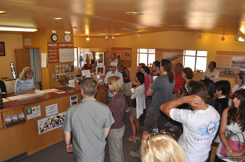 The Paria Ranger Station at 9:00am, where each day an anxious crowd gathers for a chance at the 10 coveted walk-in permits to "The Wave". |
 The Wire Pass trailhead to Buckskin Gulch is 8 miles down remote House Rock Valley Road |
 There's nothing but wilderness and pasture on House Rock Valley Road |
 After 8 miles, the trailhead to Wire Pass at a big gravel parking lot. |
 The beginning of Wire Pass |
|
The Trail |
|||||
 Wire Pass starts with a few small walls and tight spaces, then opens on to this plaza with the first big arch catching the earliest rays. |
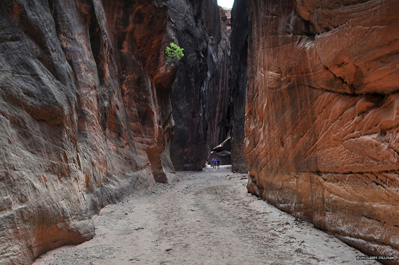
 This father-son pair were 2 of only 15 people I saw both days, and the only ones going my direction. Without people for scale, it's hard to relate the immensity of these walls. |
 High in the air, a jammed log shows the height of past water levels. The path alternates between hard pack, deep sand and big rocks. |  Every turn reveals another distinctive geologic oddity |
Backpacking in Buckskin Gulch, near Wire Pass, Vermilion Cliffs/Paria Canyon Wilderness, June 2011 |
|
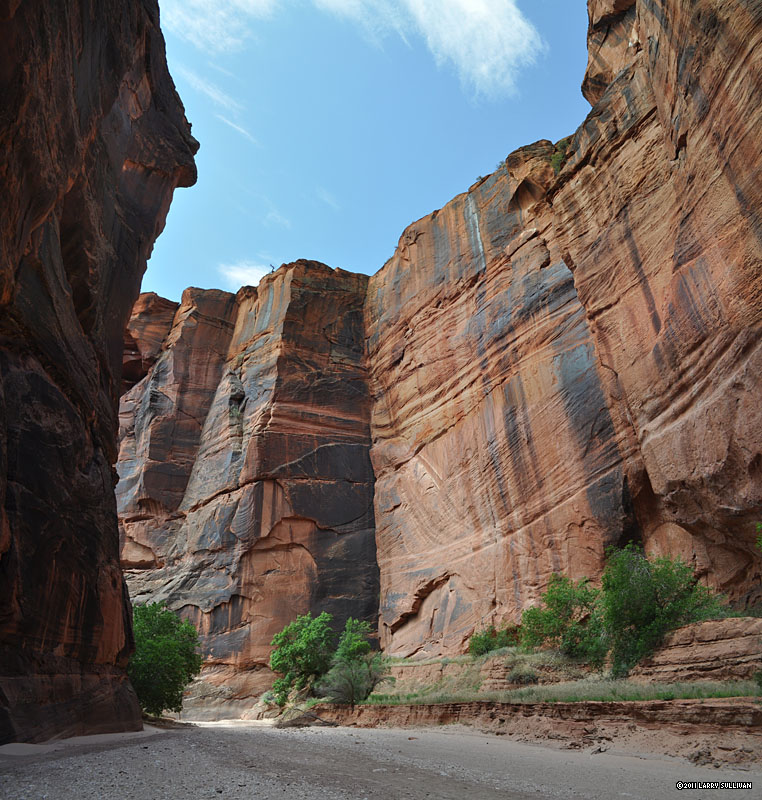
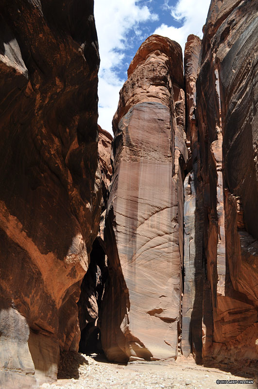
 The walls grow high and insurmountable. |
Before the sun reaches in, the lower canyon walls struggle to unveil color. |
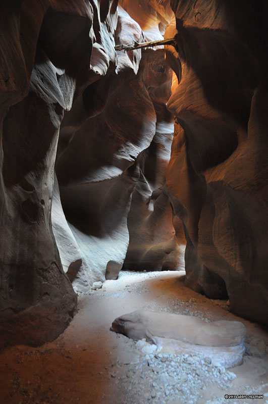
 There are moments when I feel like I've stepped onto an alien world devoid of human existence. | 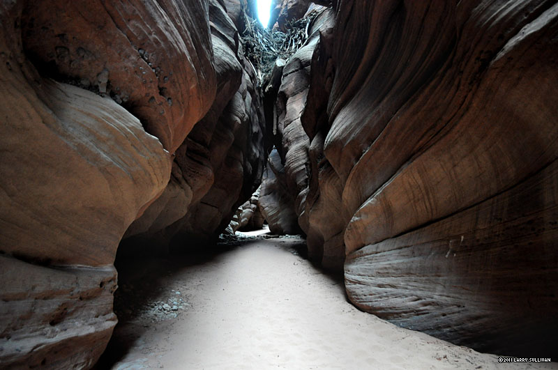 There are moments when these subterranean skylit chambers feel mystic and sacred. |
||
 In places, jammed debris from past deluges hangs from above |
 This is a rare section where the path is straight for several hundred yards. |
 Every few miles, the walls part and you enter broad courtyards. |
 Another arch, this one almost 100 feet tall. I almost wished a person would intrude - just to show the scale. |
 Black sinister walls. All the stone that fell from these arches was crushed to sand and washed away. |
 Sun, stone and sand in Buckskin Gulch. |
 After a few miles, the canyon leaves Utah and enters Arizona, which has a different time zone because it doesn't use Daylight Savings Time. (I learn this from some other hikers) |
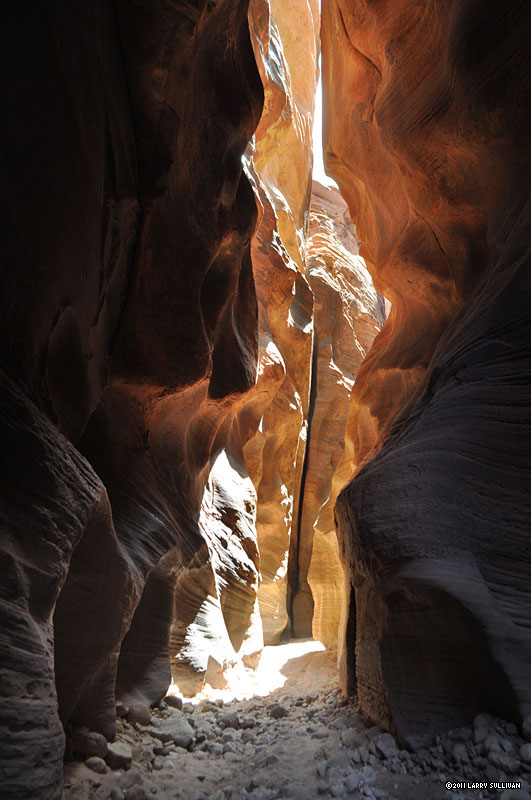
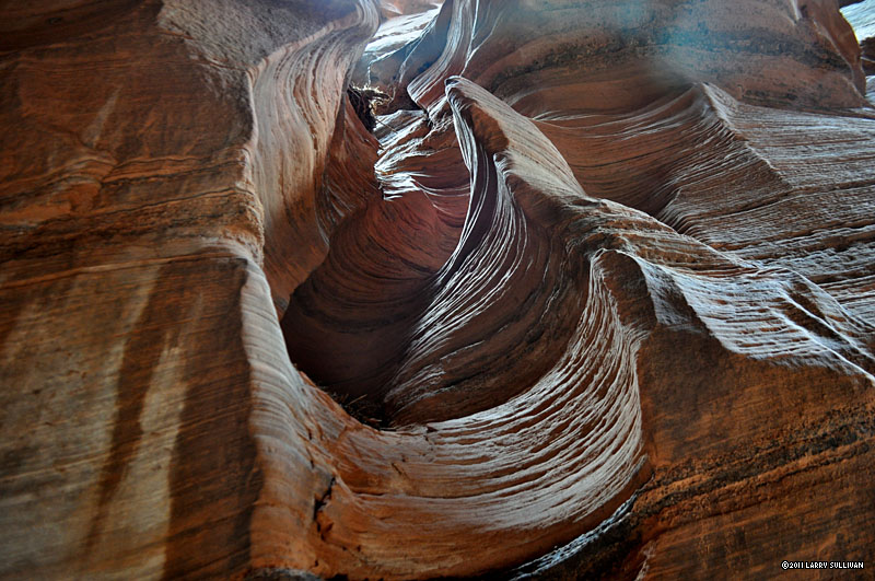
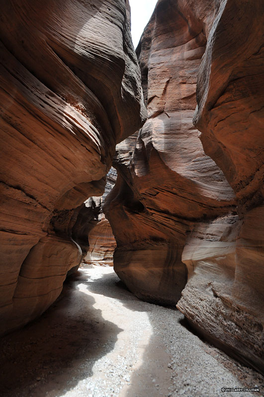
 Hour after hour, mile after mile of transcendantly luminous colors and grotesquely distorted shapes. |
 Giant open courtyards appear, then funnel back in to narrow tunnels where you can touch both walls simultaneously. |
 Some hikers pass in the opposite direction, providing a rare opportunity to show the scale of this place. |
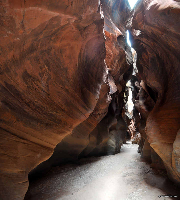
 Each bend offers a new vista more intriguing than the last. |
|
 A big log stranded 35 feet in the air. |
 Imagine how much water it would take to carve this canyon. |
 Bigger openings usually have enough sunshine to allow trees and plants to thrive. |
 Almost the entire 13 miles, the path seems exquisitely crafted to suit the scale of humans, too small at times for horses or deer. |
||
 Miles from anywhere, deep in the ground, I can imagine an ancient wanderer seeing ethereal faces of the spirits here, of which legends are born. |
|||||
 A few more hikers returning from an overnight trip to the confluence, which is my destination also. |
 This section of immense, towering red walls, hundreds of feet high, made me feel Lilliputian. |
 I have a passing thought this canyon may be as deep below the sand path as it is above - and maybe there is yawning chasm waiting to swallow up some unfortunate adventurer! |
 Mystic, eerie, enchanting - a secret silent passageway filled with light and shadows under the earth |
||
 I find that there are no mammals here, no rodents, no bats, no reptiles, not even insects. |
 At times I can hear birds singing high above but otherwise it's just the echoes of my footsteps. |
 Flood born debris lodged high on the walls. |
 Peculiar formations protrude from above. |
||
 From time to time, there is debris to climb over, and rockfalls to maneuver around. |
 The Escape Route is a steep, exposed climb up a crevice, marked only by a cairn at the time. You'd have to look back over your shoulder to see it. Only this lower part is visible - it's 150' or more to the top. |
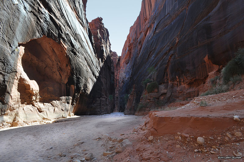
 A towering monolith at the end of an open courtyard guards the tiny entrance to continue. |
 The deep shadows and brilliant light make photography a challenge. |
 Across the open spaces, a small doorway offers more. |
 After 9+ hours out, I must be close to the confluence, verified when I meet this trio who camped there, out for an after dinner hike. |
 As clouds move across the sky, light and shadows flicker through Buckskin Gulch. |
 Fantasy formations in the final mile before the Paria River |
 I wonder how many years it took to create these shapes. |
 More scoured and tortured rock reminded me of faces. Closer to the confluence, puddles and rivulets of water appear in the path. |
 Approaching the large bend near the confluence. There are several good campsites atop mounds on either side of the the gulch |
|
 Beyond the campsites towards the confluence. |
 The Confluence of Paria canyon and Buckskin Gulch, which intersects the river at a bend.The Paria flows from northwest (left) to southeast (right). 15 miles downstream, it intersects with the Colorado River at Lee's Ferry, the beginning of the Grand Canyon. This panorama is 4 assembled pictures. |
||||
 Looking back at the big bend area from the distant point in the previous picture. |
|||||
| Day 2 | |||||
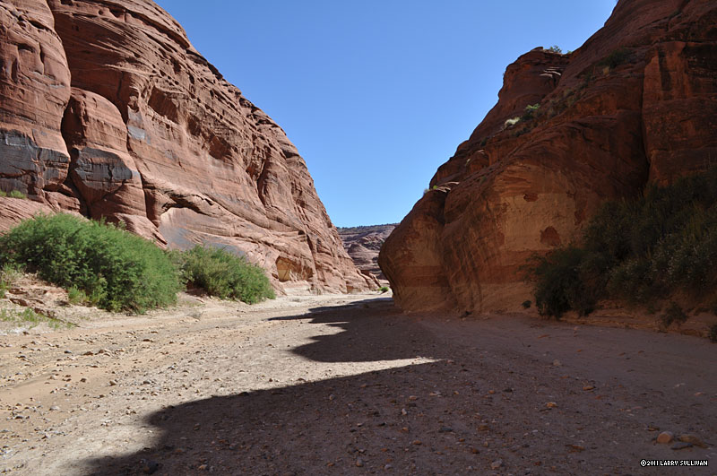
 Early the next morning, I turn north on the Paria River, which is mostly a slowly moving channel of muddy water. The path is the river bed. |
 As the sun comes up, color begins to return to Paria Canyon. It's only 8 miles from the confluence to my car at White House campground. As the sun comes up, color begins to return to Paria Canyon. It's only 8 miles from the confluence to my car at White House campground. |
 North of the confluence, the canyon slowly changes, growing wider and greener. The high walls give way to more flowing hills of stone. |
 In places, the river has gone underground and there is only mud. |
 As I proceed north, the river begins to flow stronger. I give up trying to keep my feet dry and end up crossing it dozens of times. |
 Unique mounds along the Paria |
 3 miles south of the White House campground, the Paria has carved unique "Hobbit houses" into the sandstone on both sides of the river. |
 Bizarre and amusing hydraulically-formed formations invite exploration. |
Alien habitats on the Paria River near White House campground, Vermilion Cliffs-Paria Canyon National Wilderness, Utah and Arizona. |
|||
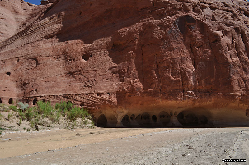 It's an interesting place to seek shelter from the hot sun. |
 Both sides of the river hold these unusual formations |
||||
 A couple in the distance explores the Hobbit houses on a dayhike from the campground. |
 The river flow has increased dramatically here, while downstream it's sluggish and muddy, obviously channeled underground. Another mile and my Paria adventure is over. |
||||
More photos in the Trip Report top of page
TOP![]() Hikes Index
Hikes Index
Since 11.07